![](/images/other/stat-length.png)
![Randonnée Marche Le Monêtier-les-Bains - Circuit Peyra + sentier botanique ( 18-06-19) - Photo](https://media.geolcdn.com/t/1900/400/ext.pjpeg?maxdim=2&url=https%3A%2F%2Fstatic1.geolcdn.com%2Fsiteimages%2Fupload%2Ffiles%2F1553511878bg_sport_marche.png)
Circuit Peyra + sentier botanique ( 18-06-19)
Thomasdanielle
Utilisateur
![Longueur](/images/other/stat-length.png)
Longueur
11 km
![Altitude max](https://static1.geolcdn.com/siteimages/upload/files/1508320355ic_sort_altitude_max_24dp.png)
Altitude max
1690 m
![Dénivelé positif](https://static1.geolcdn.com/siteimages/upload/files/1508320355ic_sort_den_pos_24dp.png)
Dénivelé positif
538 m
![Km-Effort](/images/other/stat-length.png)
Km-Effort
18,2 km
![Altitude min](https://static1.geolcdn.com/siteimages/upload/files/1508320355ic_sort_altitude_min_24dp.png)
Altitude min
1413 m
![Dénivelé négatif](https://static1.geolcdn.com/siteimages/upload/files/1508320355ic_sort_den_neg_24dp.png)
Dénivelé négatif
537 m
![Boucle](https://static1.geolcdn.com/siteimages/upload/files/16400158638029165_repeat_loop_refresh_sync_direction_icon.png)
Boucle
Oui
Date de création :
2019-06-18 07:53:36.0
Dernière modification :
2019-06-25 13:54:10.312
![Marche](https://static1.geolcdn.com/sitytour/trail-icons/101.png)
5h05
Difficulté : Très difficile
![Scannez ce code QR pour ouvrir la randonnée dans l'application SityTrail](https://capi.geolives.com/qq0zvz2zws4bq2lad0pu/sitytour/trails/2117450/qr.png?size=200)
Application GPS de randonnée GRATUITE
À propos
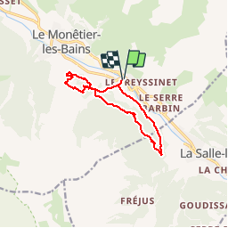
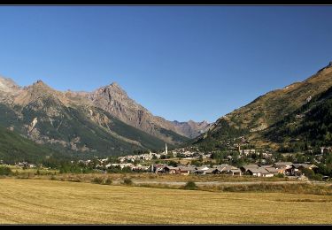
Randonnée Marche de 11 km à découvrir à Provence-Alpes-Côte d'Azur, Hautes-Alpes, Le Monêtier-les-Bains. Cette randonnée est proposée par Thomasdanielle.
Description
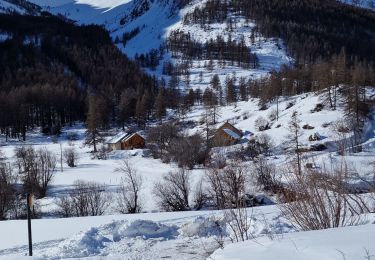
D/A : Parking derrière l'église Les GUIBERTES
Belle randonnée bien ombragée - 11 km - D. 538 m
Localisation
Pays :
France
Région :
Provence-Alpes-Côte d'Azur
Département/Province :
Hautes-Alpes
Commune :
Le Monêtier-les-Bains
Localité :
Unknown
Départ:(Dec)
Départ:(UTM)
305409 ; 4982098 (32T) N.
Commentaires
Randonnées à proximité
![Randonnée Marche La Salle-les-Alpes - le grand Aréa (boucle) - Photo](https://media.geolcdn.com/t/375/260/2c5e44d9-ecb7-452d-bd8a-94765088c19f.jpg&format=jpg&maxdim=2)
![Marche Marche](https://static1.geolcdn.com/sitytour/trail-icons/101.png)
le grand Aréa (boucle)
Marche
Moyen
La Salle-les-Alpes,
Provence-Alpes-Côte d'Azur,
Hautes-Alpes,
France
![](/images/other/stat-length.png)
7,7 km | 17,1 km-effort
4h 49min
![](https://static1.geolcdn.com/siteimages/upload/files/16400158638029165_repeat_loop_refresh_sync_direction_icon.png)
Oui
![Randonnée Marche La Salle-les-Alpes - Boucle grand AREA - Photo](https://media.geolcdn.com/t/375/260/86fd0548-34c0-4cb0-a2ba-6eed03b231af.jpg&format=jpg&maxdim=2)
![Marche Marche](https://static1.geolcdn.com/sitytour/trail-icons/101.png)
Boucle grand AREA
Marche
Difficile
La Salle-les-Alpes,
Provence-Alpes-Côte d'Azur,
Hautes-Alpes,
France
![](/images/other/stat-length.png)
9,4 km | 18,5 km-effort
3h 41min
![](https://static1.geolcdn.com/siteimages/upload/files/16400158638029165_repeat_loop_refresh_sync_direction_icon.png)
Oui
![Randonnée Marche Saint-Chaffrey - Chantemerle-la Salle les Aples 13-08-2018 - Photo](https://media.geolcdn.com/t/375/260/ext.jpg?maxdim=2&url=https%3A%2F%2Fstatic1.geolcdn.com%2Fsiteimages%2Fupload%2Ffiles%2F1553511878bg_sport_marche.png)
![Marche Marche](https://static1.geolcdn.com/sitytour/trail-icons/101.png)
Chantemerle-la Salle les Aples 13-08-2018
Marche
Facile
(1)
Saint-Chaffrey,
Provence-Alpes-Côte d'Azur,
Hautes-Alpes,
France
![](/images/other/stat-length.png)
9,7 km | 15,9 km-effort
2h 56min
![](https://static1.geolcdn.com/siteimages/upload/files/16400158638029165_repeat_loop_refresh_sync_direction_icon.png)
Non
![Randonnée Marche Le Monêtier-les-Bains - Lac du Glacier d'Arsine - Photo](https://media.geolcdn.com/t/375/260/ext.jpg?maxdim=2&url=https%3A%2F%2Fstatic1.geolcdn.com%2Fsiteimages%2Fupload%2Ffiles%2F1553511878bg_sport_marche.png)
![Marche Marche](https://static1.geolcdn.com/sitytour/trail-icons/101.png)
Lac du Glacier d'Arsine
Marche
Difficile
(1)
Le Monêtier-les-Bains,
Provence-Alpes-Côte d'Azur,
Hautes-Alpes,
France
![](/images/other/stat-length.png)
16,3 km | 29 km-effort
Inconnu
![](https://static1.geolcdn.com/siteimages/upload/files/16400158638029165_repeat_loop_refresh_sync_direction_icon.png)
Oui
![Randonnée Marche nordique Le Monêtier-les-Bains - Lac de la douché par le tabac - Photo](https://media.geolcdn.com/t/375/260/47bcc50e-00de-419a-af78-2ed39ac0fd05.jpg&format=jpg&maxdim=2)
![Marche nordique Marche nordique](https://static1.geolcdn.com/sitytour/trail-icons/102.png)
Lac de la douché par le tabac
Marche nordique
Moyen
Le Monêtier-les-Bains,
Provence-Alpes-Côte d'Azur,
Hautes-Alpes,
France
![](/images/other/stat-length.png)
7,9 km | 13,1 km-effort
2h 50min
![](https://static1.geolcdn.com/siteimages/upload/files/16400158638029165_repeat_loop_refresh_sync_direction_icon.png)
Oui
![Randonnée Marche Le Monêtier-les-Bains - Boucle des Conchiers - Photo](https://media.geolcdn.com/t/375/260/c38d54e3-0bae-4445-9416-7972754b0578.jpg&format=jpg&maxdim=2)
![Marche Marche](https://static1.geolcdn.com/sitytour/trail-icons/101.png)
Boucle des Conchiers
Marche
Facile
Le Monêtier-les-Bains,
Provence-Alpes-Côte d'Azur,
Hautes-Alpes,
France
![](/images/other/stat-length.png)
7,8 km | 13,9 km-effort
2h 41min
![](https://static1.geolcdn.com/siteimages/upload/files/16400158638029165_repeat_loop_refresh_sync_direction_icon.png)
Oui
![Randonnée Marche Le Monêtier-les-Bains - Les Boussardes - Photo](https://media.geolcdn.com/t/375/260/404ff157-d268-4b88-bced-a12b6573121a.jpg&format=jpg&maxdim=2)
![Marche Marche](https://static1.geolcdn.com/sitytour/trail-icons/101.png)
Les Boussardes
Marche
Facile
Le Monêtier-les-Bains,
Provence-Alpes-Côte d'Azur,
Hautes-Alpes,
France
![](/images/other/stat-length.png)
15,7 km | 19,2 km-effort
5h 1min
![](https://static1.geolcdn.com/siteimages/upload/files/16400158638029165_repeat_loop_refresh_sync_direction_icon.png)
Non
![Randonnée Marche Le Monêtier-les-Bains - Grand Aréa - Photo](https://media.geolcdn.com/t/375/260/183c96a2-203b-45f5-bf34-18c8407695c1.jpg&format=jpg&maxdim=2)
![Marche Marche](https://static1.geolcdn.com/sitytour/trail-icons/101.png)
Grand Aréa
Marche
Difficile
Le Monêtier-les-Bains,
Provence-Alpes-Côte d'Azur,
Hautes-Alpes,
France
![](/images/other/stat-length.png)
25 km | 46 km-effort
8h 1min
![](https://static1.geolcdn.com/siteimages/upload/files/16400158638029165_repeat_loop_refresh_sync_direction_icon.png)
Oui
![Randonnée Marche Le Monêtier-les-Bains - Lac de la douche - Photo](https://media.geolcdn.com/t/375/260/bcd05975-2530-4e50-a4b6-2c24319da2f7.jpg&format=jpg&maxdim=2)
![Marche Marche](https://static1.geolcdn.com/sitytour/trail-icons/101.png)
Lac de la douche
Marche
Facile
(1)
Le Monêtier-les-Bains,
Provence-Alpes-Côte d'Azur,
Hautes-Alpes,
France
![](/images/other/stat-length.png)
7,2 km | 12,3 km-effort
1h 44min
![](https://static1.geolcdn.com/siteimages/upload/files/16400158638029165_repeat_loop_refresh_sync_direction_icon.png)
Oui