![](/images/other/stat-length.png)
![Randonnée Marche Villar-d'Arêne - Lac d'Arsine ( Parking long Romanche) (14 km - D. 790 m) - Photo](https://media.geolcdn.com/t/1900/400/ext.pjpeg?maxdim=2&url=https%3A%2F%2Fstatic1.geolcdn.com%2Fsiteimages%2Fupload%2Ffiles%2F1553511878bg_sport_marche.png)
Lac d'Arsine ( Parking long Romanche) (14 km - D. 790 m)
Thomasdanielle
Utilisateur
![Longueur](/images/other/stat-length.png)
![Altitude max](https://static1.geolcdn.com/siteimages/upload/files/1508320355ic_sort_altitude_max_24dp.png)
![Dénivelé positif](https://static1.geolcdn.com/siteimages/upload/files/1508320355ic_sort_den_pos_24dp.png)
![Km-Effort](/images/other/stat-length.png)
![Altitude min](https://static1.geolcdn.com/siteimages/upload/files/1508320355ic_sort_altitude_min_24dp.png)
![Dénivelé négatif](https://static1.geolcdn.com/siteimages/upload/files/1508320355ic_sort_den_neg_24dp.png)
![Boucle](https://static1.geolcdn.com/siteimages/upload/files/16400158638029165_repeat_loop_refresh_sync_direction_icon.png)
![Marche](https://static1.geolcdn.com/sitytour/trail-icons/101.png)
3h22
Difficulté : Difficile
![Scannez ce code QR pour ouvrir la randonnée dans l'application SityTrail](https://capi.geolives.com/qq0zvz2zws4bq2lad0pu/sitytour/trails/2112519/qr.png?size=200)
Application GPS de randonnée GRATUITE
À propos
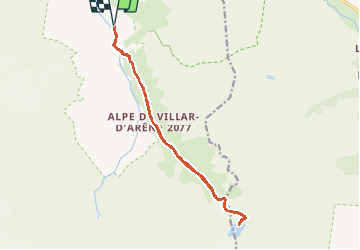
Randonnée Marche de 14,4 km à découvrir à Provence-Alpes-Côte d'Azur, Hautes-Alpes, Villar-d'Arêne. Cette randonnée est proposée par Thomasdanielle.
Description
D/A : IGN n° 3436 Est
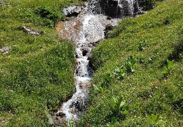
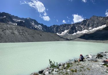
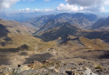
Le sentier aller/Retour chemine facilement dans les Alpage sur le GR54, puis devient une piste qui longe le bord de la Moraine avant d'atteindre le Lac l'Arsine. Très joli Lac glaciaire, il offre en outre une vue sur la montagnes des Agneaux, sur le pic de Neige Cordier et sur les nombreux pics du Combeynot et le glacier d'Arsine.
Au niveau de alt. 2340 quiter le GR54, virer sur la droite pour rejoindre le lac d'Arsine.
Retour par le même sentier pour arriver au parking.
Localisation
Commentaires
Randonnées à proximité
![Randonnée Marche Villar-d'Arêne - L'Aiguillon et Lac du Pontet 28.8.22 - Photo](https://media.geolcdn.com/t/375/260/007e50a5-b3c9-4529-9bf1-1ab760d39579.jpg&format=jpg&maxdim=2)
![Marche Marche](https://static1.geolcdn.com/sitytour/trail-icons/101.png)
Marche
![](/images/other/stat-length.png)
![](https://static1.geolcdn.com/siteimages/upload/files/16400158638029165_repeat_loop_refresh_sync_direction_icon.png)
![Randonnée Ski de randonnée Villar-d'Arêne - Roc noir de Combeynot - Photo](https://media.geolcdn.com/t/375/260/31d3bf16-d2df-42fc-9fef-f746677c1101.jpg&format=jpg&maxdim=2)
![Ski de randonnée Ski de randonnée](https://static1.geolcdn.com/sitytour/trail-icons/503.png)
Ski de randonnée
![](/images/other/stat-length.png)
![](https://static1.geolcdn.com/siteimages/upload/files/16400158638029165_repeat_loop_refresh_sync_direction_icon.png)
![Randonnée Marche La Grave - 05 lac goleon - Photo](https://media.geolcdn.com/t/375/260/abf8f99e-f4a4-42bd-8090-69a0a4a7cd63.jpg&format=jpg&maxdim=2)
![Marche Marche](https://static1.geolcdn.com/sitytour/trail-icons/101.png)
Marche
![](/images/other/stat-length.png)
![](https://static1.geolcdn.com/siteimages/upload/files/16400158638029165_repeat_loop_refresh_sync_direction_icon.png)
![Randonnée Marche Villar-d'Arêne - Lac d'Arsine - Photo](https://media.geolcdn.com/t/375/260/e7f87057-c742-4181-83c9-59ebf50a12c8.jpg&format=jpg&maxdim=2)
![Marche Marche](https://static1.geolcdn.com/sitytour/trail-icons/101.png)
Marche
![](/images/other/stat-length.png)
![](https://static1.geolcdn.com/siteimages/upload/files/16400158638029165_repeat_loop_refresh_sync_direction_icon.png)
![Randonnée Marche Le Monêtier-les-Bains - Pic Blanc du Galibier - Photo](https://media.geolcdn.com/t/375/260/50ed979f-f708-4034-9dd2-18865bd9cea5.jpg&format=jpg&maxdim=2)
![Marche Marche](https://static1.geolcdn.com/sitytour/trail-icons/101.png)
Marche
![](/images/other/stat-length.png)
![](https://static1.geolcdn.com/siteimages/upload/files/16400158638029165_repeat_loop_refresh_sync_direction_icon.png)
![Randonnée Marche Villar-d'Arêne - Lac du pontet et l'Aiguillon - Photo](https://media.geolcdn.com/t/375/260/ext.jpg?maxdim=2&url=https%3A%2F%2Fstatic1.geolcdn.com%2Fsiteimages%2Fupload%2Ffiles%2F1553511878bg_sport_marche.png)
![Marche Marche](https://static1.geolcdn.com/sitytour/trail-icons/101.png)
Marche
![](/images/other/stat-length.png)
![](https://static1.geolcdn.com/siteimages/upload/files/16400158638029165_repeat_loop_refresh_sync_direction_icon.png)
![Randonnée Marche Villar-d'Arêne - le refuge de l'alpe de Villard d’arène - Photo](https://media.geolcdn.com/t/375/260/ext.jpg?maxdim=2&url=https%3A%2F%2Fservices.sitytrail.com%2FGeolivesWS%2FDownloadMedia.ashx%3FTrailID%3D1009230%26Media%3Dfix__20180723140354.jpg)
![Marche Marche](https://static1.geolcdn.com/sitytour/trail-icons/101.png)
Marche
![](/images/other/stat-length.png)
![](https://static1.geolcdn.com/siteimages/upload/files/16400158638029165_repeat_loop_refresh_sync_direction_icon.png)
![Randonnée Marche Villar-d'Arêne - Lac d’arcane - Photo](https://media.geolcdn.com/t/375/260/b9371523-4ec7-4cdd-ad8e-d13839f22c25.jpg&format=jpg&maxdim=2)
![Marche Marche](https://static1.geolcdn.com/sitytour/trail-icons/101.png)
Marche
![](/images/other/stat-length.png)
![](https://static1.geolcdn.com/siteimages/upload/files/16400158638029165_repeat_loop_refresh_sync_direction_icon.png)
![Randonnée Marche Le Monêtier-les-Bains - Pic Blanc du Galibier 2955m 25.8.22 - Photo](https://media.geolcdn.com/t/375/260/5cc85e14-39d7-4a86-9bab-48cc085d9ce9.jpg&format=jpg&maxdim=2)
![Marche Marche](https://static1.geolcdn.com/sitytour/trail-icons/101.png)
Marche
![](/images/other/stat-length.png)
![](https://static1.geolcdn.com/siteimages/upload/files/16400158638029165_repeat_loop_refresh_sync_direction_icon.png)