![](/images/other/stat-length.png)
![Randonnée Marche Clef-Vallée-d'Eure - 2019_06_Fontaine Heudebourg - Photo](https://media.geolcdn.com/t/1900/400/ext.pjpeg?maxdim=2&url=https%3A%2F%2Fstatic1.geolcdn.com%2Fsiteimages%2Fupload%2Ffiles%2F1553511878bg_sport_marche.png)
2019_06_Fontaine Heudebourg
jeanlucien
Utilisateur
![Longueur](/images/other/stat-length.png)
Longueur
10,8 km
![Altitude max](https://static1.geolcdn.com/siteimages/upload/files/1508320355ic_sort_altitude_max_24dp.png)
Altitude max
153 m
![Dénivelé positif](https://static1.geolcdn.com/siteimages/upload/files/1508320355ic_sort_den_pos_24dp.png)
Dénivelé positif
227 m
![Km-Effort](/images/other/stat-length.png)
Km-Effort
13,8 km
![Altitude min](https://static1.geolcdn.com/siteimages/upload/files/1508320355ic_sort_altitude_min_24dp.png)
Altitude min
26 m
![Dénivelé négatif](https://static1.geolcdn.com/siteimages/upload/files/1508320355ic_sort_den_neg_24dp.png)
Dénivelé négatif
229 m
![Boucle](https://static1.geolcdn.com/siteimages/upload/files/16400158638029165_repeat_loop_refresh_sync_direction_icon.png)
Boucle
Oui
Date de création :
2019-06-12 21:00:35.968
Dernière modification :
2019-06-13 13:19:55.2
![Marche](https://static1.geolcdn.com/sitytour/trail-icons/101.png)
2h46
Difficulté : Difficile
![Scannez ce code QR pour ouvrir la randonnée dans l'application SityTrail](https://capi.geolives.com/qq0zvz2zws4bq2lad0pu/sitytour/trails/2112362/qr.png?size=200)
Application GPS de randonnée GRATUITE
À propos
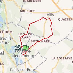
Randonnée Marche de 10,8 km à découvrir à Normandie, Eure, Clef-Vallée-d'Eure. Cette randonnée est proposée par jeanlucien.
Description
Attention pente bois des Bobettes très raide et très glossante par temps de pluie.
Metreville - Bois Ricard par route, car chemins disparus
Localisation
Pays :
France
Région :
Normandie
Département/Province :
Eure
Commune :
Clef-Vallée-d'Eure
Localité :
Unknown
Départ:(Dec)
Départ:(UTM)
369501 ; 5443413 (31U) N.
Commentaires
Randonnées à proximité
![Randonnée Marche Clef-Vallée-d'Eure - Ecardenville sur Eure (122) - Photo](https://media.geolcdn.com/t/375/260/ext.jpg?maxdim=2&url=https%3A%2F%2Fstatic1.geolcdn.com%2Fsiteimages%2Fupload%2Ffiles%2F1553511878bg_sport_marche.png)
![Marche Marche](https://static1.geolcdn.com/sitytour/trail-icons/101.png)
Ecardenville sur Eure (122)
Marche
Facile
(1)
Clef-Vallée-d'Eure,
Normandie,
Eure,
France
![](/images/other/stat-length.png)
11,1 km | 13,2 km-effort
2h 54min
![](https://static1.geolcdn.com/siteimages/upload/files/16400158638029165_repeat_loop_refresh_sync_direction_icon.png)
Oui
![Marche Marche](https://static1.geolcdn.com/sitytour/trail-icons/101.png)
20240323-La Croix St Leuffroy
Marche
Moyen
Clef-Vallée-d'Eure,
Normandie,
Eure,
France
![](/images/other/stat-length.png)
11,1 km | 13,1 km-effort
3h 22min
![](https://static1.geolcdn.com/siteimages/upload/files/16400158638029165_repeat_loop_refresh_sync_direction_icon.png)
Oui
![Marche Marche](https://static1.geolcdn.com/sitytour/trail-icons/101.png)
20231012-Amfreville sur Iton
Marche
Moyen
(1)
Amfreville-sur-Iton,
Normandie,
Eure,
France
![](/images/other/stat-length.png)
11,6 km | 14,4 km-effort
3h 17min
![](https://static1.geolcdn.com/siteimages/upload/files/16400158638029165_repeat_loop_refresh_sync_direction_icon.png)
Oui
![Randonnée Marche Amfreville-sur-Iton - rando amfreville sur iton - Photo](https://media.geolcdn.com/t/375/260/1ae1478e-8362-45f5-95df-868478733425.jpg&format=jpg&maxdim=2)
![Marche Marche](https://static1.geolcdn.com/sitytour/trail-icons/101.png)
rando amfreville sur iton
Marche
Moyen
Amfreville-sur-Iton,
Normandie,
Eure,
France
![](/images/other/stat-length.png)
12,5 km | 15,4 km-effort
3h 18min
![](https://static1.geolcdn.com/siteimages/upload/files/16400158638029165_repeat_loop_refresh_sync_direction_icon.png)
Oui
![Randonnée Marche Autheuil-Authouillet - Ecardenville 6 novembre 2022 - Photo](https://media.geolcdn.com/t/375/260/ext.jpg?maxdim=2&url=https%3A%2F%2Fstatic1.geolcdn.com%2Fsiteimages%2Fupload%2Ffiles%2F1553511878bg_sport_marche.png)
![Marche Marche](https://static1.geolcdn.com/sitytour/trail-icons/101.png)
Ecardenville 6 novembre 2022
Marche
Difficile
(1)
Autheuil-Authouillet,
Normandie,
Eure,
France
![](/images/other/stat-length.png)
10,8 km | 13 km-effort
2h 54min
![](https://static1.geolcdn.com/siteimages/upload/files/16400158638029165_repeat_loop_refresh_sync_direction_icon.png)
Oui
![Marche Marche](https://static1.geolcdn.com/sitytour/trail-icons/101.png)
20220628-Heudreville le Jardin de René
Marche
Moyen
Heudreville-sur-Eure,
Normandie,
Eure,
France
![](/images/other/stat-length.png)
12 km | 14,1 km-effort
3h 37min
![](https://static1.geolcdn.com/siteimages/upload/files/16400158638029165_repeat_loop_refresh_sync_direction_icon.png)
Oui
![Marche Marche](https://static1.geolcdn.com/sitytour/trail-icons/101.png)
20220129-Amfreville sur Iton
Marche
Moyen
Amfreville-sur-Iton,
Normandie,
Eure,
France
![](/images/other/stat-length.png)
11,4 km | 14,2 km-effort
3h 5min
![](https://static1.geolcdn.com/siteimages/upload/files/16400158638029165_repeat_loop_refresh_sync_direction_icon.png)
Oui
![Randonnée Vélo de route Acquigny - Acquis y rando vélo - Photo](https://media.geolcdn.com/t/375/260/ef4ceab2-1345-4b6b-a40a-ecfa46ab375d.jpg&format=jpg&maxdim=2)
![Vélo de route Vélo de route](https://static1.geolcdn.com/sitytour/trail-icons/201.png)
Acquis y rando vélo
Vélo de route
Acquigny,
Normandie,
Eure,
France
![](/images/other/stat-length.png)
70 km | 80 km-effort
3h 28min
![](https://static1.geolcdn.com/siteimages/upload/files/16400158638029165_repeat_loop_refresh_sync_direction_icon.png)
Non
![Randonnée Marche Acquigny - Acquigny -Vers le Becdal par la mare Hermier - Photo](https://media.geolcdn.com/t/375/260/ef76d62e-c014-482a-b5da-dbf90d427cbf.jpg&format=jpg&maxdim=2)
![Marche Marche](https://static1.geolcdn.com/sitytour/trail-icons/101.png)
Acquigny -Vers le Becdal par la mare Hermier
Marche
Moyen
Acquigny,
Normandie,
Eure,
France
![](/images/other/stat-length.png)
13,3 km | 16 km-effort
3h 41min
![](https://static1.geolcdn.com/siteimages/upload/files/16400158638029165_repeat_loop_refresh_sync_direction_icon.png)
Oui