![](/images/other/stat-length.png)
![Randonnée Vélo Meyrargues - EuroVelo 8 - Meyrargues - Draguignan - Photo](https://media.geolcdn.com/t/1900/400/ext.pjpeg?maxdim=2&url=https%3A%2F%2Fstatic1.geolcdn.com%2Fsiteimages%2Fupload%2Ffiles%2F1524743154velo.jpg)
EuroVelo 8 - Meyrargues - Draguignan
EuroVelo 8
Pour tout ceux qui veulent voyager en Europe à vélo GUIDE+
![Longueur](/images/other/stat-length.png)
Longueur
107 km
![Altitude max](https://static1.geolcdn.com/siteimages/upload/files/1508320355ic_sort_altitude_max_24dp.png)
Altitude max
442 m
![Dénivelé positif](https://static1.geolcdn.com/siteimages/upload/files/1508320355ic_sort_den_pos_24dp.png)
Dénivelé positif
1424 m
![Km-Effort](/images/other/stat-length.png)
Km-Effort
126 km
![Altitude min](https://static1.geolcdn.com/siteimages/upload/files/1508320355ic_sort_altitude_min_24dp.png)
Altitude min
180 m
![Dénivelé négatif](https://static1.geolcdn.com/siteimages/upload/files/1508320355ic_sort_den_neg_24dp.png)
Dénivelé négatif
1448 m
![Boucle](https://static1.geolcdn.com/siteimages/upload/files/16400158638029165_repeat_loop_refresh_sync_direction_icon.png)
Boucle
Non
Date de création :
2019-06-10 09:12:34.864
Dernière modification :
2019-06-10 09:13:13.37
![Vélo](https://static1.geolcdn.com/sitytour/trail-icons/200.png)
--
Difficulté : Moyen
![Scannez ce code QR pour ouvrir la randonnée dans l'application SityTrail](https://capi.geolives.com/qq0zvz2zws4bq2lad0pu/sitytour/trails/2109839/qr.png?size=200)
Application GPS de randonnée GRATUITE
À propos
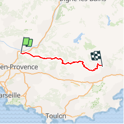
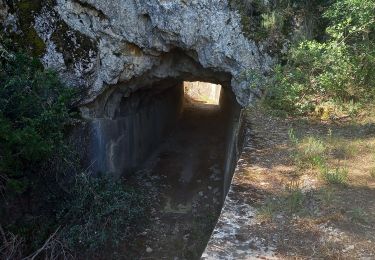
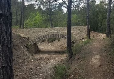
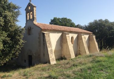
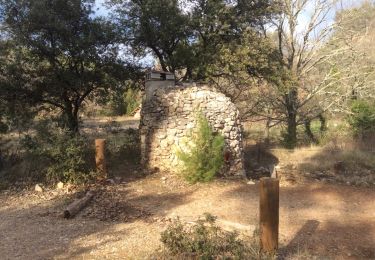
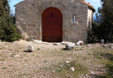
Randonnée Vélo de 107 km à découvrir à Provence-Alpes-Côte d'Azur, Bouches-du-Rhône, Meyrargues. Cette randonnée est proposée par EuroVelo 8.
Description
EuroVelo 8 - Meyrargues - Draguignan
Localisation
Pays :
France
Région :
Provence-Alpes-Côte d'Azur
Département/Province :
Bouches-du-Rhône
Commune :
Meyrargues
Localité :
Unknown
Départ:(Dec)
Départ:(UTM)
704843 ; 4835448 (31T) N.
Commentaires
Randonnées à proximité
![Marche Marche](https://static1.geolcdn.com/sitytour/trail-icons/101.png)
PF-Meyrargues - Les Calanques
Marche
Facile
Meyrargues,
Provence-Alpes-Côte d'Azur,
Bouches-du-Rhône,
France
![](/images/other/stat-length.png)
14 km | 20 km-effort
4h 11min
![](https://static1.geolcdn.com/siteimages/upload/files/16400158638029165_repeat_loop_refresh_sync_direction_icon.png)
Oui
![Randonnée Marche Meyrargues - Meyrargue Camp chinois Vallon du petit - Photo](https://media.geolcdn.com/t/375/260/bdb76f07-312d-4412-8213-94a98c001771.jpg&format=jpg&maxdim=2)
![Marche Marche](https://static1.geolcdn.com/sitytour/trail-icons/101.png)
Meyrargue Camp chinois Vallon du petit
Marche
Moyen
Meyrargues,
Provence-Alpes-Côte d'Azur,
Bouches-du-Rhône,
France
![](/images/other/stat-length.png)
11,4 km | 17 km-effort
4h 2min
![](https://static1.geolcdn.com/siteimages/upload/files/16400158638029165_repeat_loop_refresh_sync_direction_icon.png)
Oui
![Randonnée Marche Peyrolles-en-Provence - Le Concors - Peyrolles- Jouques GR2C - Photo](https://media.geolcdn.com/t/375/260/ext.jpg?maxdim=2&url=https%3A%2F%2Fstatic1.geolcdn.com%2Fsiteimages%2Fupload%2Ffiles%2F1553511878bg_sport_marche.png)
![Marche Marche](https://static1.geolcdn.com/sitytour/trail-icons/101.png)
Le Concors - Peyrolles- Jouques GR2C
Marche
Difficile
(1)
Peyrolles-en-Provence,
Provence-Alpes-Côte d'Azur,
Bouches-du-Rhône,
France
![](/images/other/stat-length.png)
12,2 km | 18,7 km-effort
4h 14min
![](https://static1.geolcdn.com/siteimages/upload/files/16400158638029165_repeat_loop_refresh_sync_direction_icon.png)
Non
![Randonnée Marche Peyrolles-en-Provence - la trempasse - Photo](https://media.geolcdn.com/t/375/260/e81bfe05-4381-4fe4-ad99-dbec04ae9128.jpg&format=jpg&maxdim=2)
![Marche Marche](https://static1.geolcdn.com/sitytour/trail-icons/101.png)
la trempasse
Marche
Moyen
Peyrolles-en-Provence,
Provence-Alpes-Côte d'Azur,
Bouches-du-Rhône,
France
![](/images/other/stat-length.png)
10,4 km | 16,3 km-effort
3h 49min
![](https://static1.geolcdn.com/siteimages/upload/files/16400158638029165_repeat_loop_refresh_sync_direction_icon.png)
Oui
![Randonnée Marche Peyrolles-en-Provence - Ancien canal du Verdon 1.5.22 - Photo](https://media.geolcdn.com/t/375/260/62ebffa6-ce90-44d1-8a5a-2da46d971824.jpg&format=jpg&maxdim=2)
![Marche Marche](https://static1.geolcdn.com/sitytour/trail-icons/101.png)
Ancien canal du Verdon 1.5.22
Marche
Facile
Peyrolles-en-Provence,
Provence-Alpes-Côte d'Azur,
Bouches-du-Rhône,
France
![](/images/other/stat-length.png)
11,5 km | 14,9 km-effort
3h 40min
![](https://static1.geolcdn.com/siteimages/upload/files/16400158638029165_repeat_loop_refresh_sync_direction_icon.png)
Oui
![Randonnée Marche Peyrolles-en-Provence - loubatas-Camp Chinois-retour par les vallons - Photo](https://media.geolcdn.com/t/375/260/eef47ac4-c641-43d2-bb84-26631de69203.jpg&format=jpg&maxdim=2)
![Marche Marche](https://static1.geolcdn.com/sitytour/trail-icons/101.png)
loubatas-Camp Chinois-retour par les vallons
Marche
Très difficile
(2)
Peyrolles-en-Provence,
Provence-Alpes-Côte d'Azur,
Bouches-du-Rhône,
France
![](/images/other/stat-length.png)
15,3 km | 20 km-effort
3h 23min
![](https://static1.geolcdn.com/siteimages/upload/files/16400158638029165_repeat_loop_refresh_sync_direction_icon.png)
Oui
![Randonnée Marche Peyrolles-en-Provence - PF-Peyrolles-en-Provence - Notre Dame d'Astors - Photo](https://media.geolcdn.com/t/375/260/da3fa0b3-39ff-44df-8458-8b11162830b1.jpg&format=jpg&maxdim=2)
![Marche Marche](https://static1.geolcdn.com/sitytour/trail-icons/101.png)
PF-Peyrolles-en-Provence - Notre Dame d'Astors
Marche
Moyen
Peyrolles-en-Provence,
Provence-Alpes-Côte d'Azur,
Bouches-du-Rhône,
France
![](/images/other/stat-length.png)
10,2 km | 12,5 km-effort
2h 36min
![](https://static1.geolcdn.com/siteimages/upload/files/16400158638029165_repeat_loop_refresh_sync_direction_icon.png)
Oui
![Randonnée Marche Peyrolles-en-Provence - PF-Peyrolles-en-Provence - Sentier du Loubatas - Photo](https://media.geolcdn.com/t/375/260/ext.jpg?maxdim=2&url=https%3A%2F%2Fservices.sitytrail.com%2FGeolivesWS%2FDownloadMedia.ashx%3FTrailID%3D537957%26Media%3D20160314160329.jpg)
![Marche Marche](https://static1.geolcdn.com/sitytour/trail-icons/101.png)
PF-Peyrolles-en-Provence - Sentier du Loubatas
Marche
Facile
Peyrolles-en-Provence,
Provence-Alpes-Côte d'Azur,
Bouches-du-Rhône,
France
![](/images/other/stat-length.png)
8,8 km | 11,7 km-effort
2h 36min
![](https://static1.geolcdn.com/siteimages/upload/files/16400158638029165_repeat_loop_refresh_sync_direction_icon.png)
Oui
![Randonnée Marche Peyrolles-en-Provence - la tempasse - Photo](https://media.geolcdn.com/t/375/260/253441c1-cd24-4537-b6b4-638da0c1444f.jpg&format=jpg&maxdim=2)
![Marche Marche](https://static1.geolcdn.com/sitytour/trail-icons/101.png)
la tempasse
Marche
Moyen
Peyrolles-en-Provence,
Provence-Alpes-Côte d'Azur,
Bouches-du-Rhône,
France
![](/images/other/stat-length.png)
10,3 km | 16,1 km-effort
3h 14min
![](https://static1.geolcdn.com/siteimages/upload/files/16400158638029165_repeat_loop_refresh_sync_direction_icon.png)
Oui