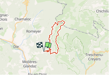
![](/images/other/stat-length.png)
![Randonnée Marche Die - Le Glandasse - Col des Bachassons par Valcroissant - Photo](https://media.geolcdn.com/t/1900/400/c1deba48-634e-4264-a42e-9747f3a88aeb.jpg&format=pjpeg&maxdim=2)
Le Glandasse - Col des Bachassons par Valcroissant
Philindy26
Utilisateur
![Longueur](/images/other/stat-length.png)
![Altitude max](https://static1.geolcdn.com/siteimages/upload/files/1508320355ic_sort_altitude_max_24dp.png)
![Dénivelé positif](https://static1.geolcdn.com/siteimages/upload/files/1508320355ic_sort_den_pos_24dp.png)
![Km-Effort](/images/other/stat-length.png)
![Altitude min](https://static1.geolcdn.com/siteimages/upload/files/1508320355ic_sort_altitude_min_24dp.png)
![Dénivelé négatif](https://static1.geolcdn.com/siteimages/upload/files/1508320355ic_sort_den_neg_24dp.png)
![Boucle](https://static1.geolcdn.com/siteimages/upload/files/16400158638029165_repeat_loop_refresh_sync_direction_icon.png)
![Marche](https://static1.geolcdn.com/sitytour/trail-icons/101.png)
6h30
Difficulté : Très difficile
![Scannez ce code QR pour ouvrir la randonnée dans l'application SityTrail](https://capi.geolives.com/qq0zvz2zws4bq2lad0pu/sitytour/trails/2109525/qr.png?size=200)
Application GPS de randonnée GRATUITE
À propos
Randonnée Marche de 27 km à découvrir à Auvergne-Rhône-Alpes, Drôme, Die. Cette randonnée est proposée par Philindy26.
Description
Départ de l'abbaye de Valcroissant à Die (651 m)...
Géolocalisation (Google Maps) : https://goo.gl/maps/t38pzYLnE1uLgqq67 .
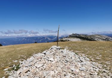
Prendre la direction du Fays (953 m), les Quatre Chemins (1021 m), le col de Ménil (1125 m), Bonne Combe (1079 m) et le col des Bachassons (1661 m).
Puis traversée le plateau en prenant la direction de la Jasse de la Ville et suivre le GR91 jusqu'à la Palle.
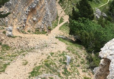
Descendre sur l'Abbaye par le Comptoir à Moutons (1520 m), la Fontaine de Juillet (1058 m). les Quatre Chemins (1021 m) et le Fays (953 m).
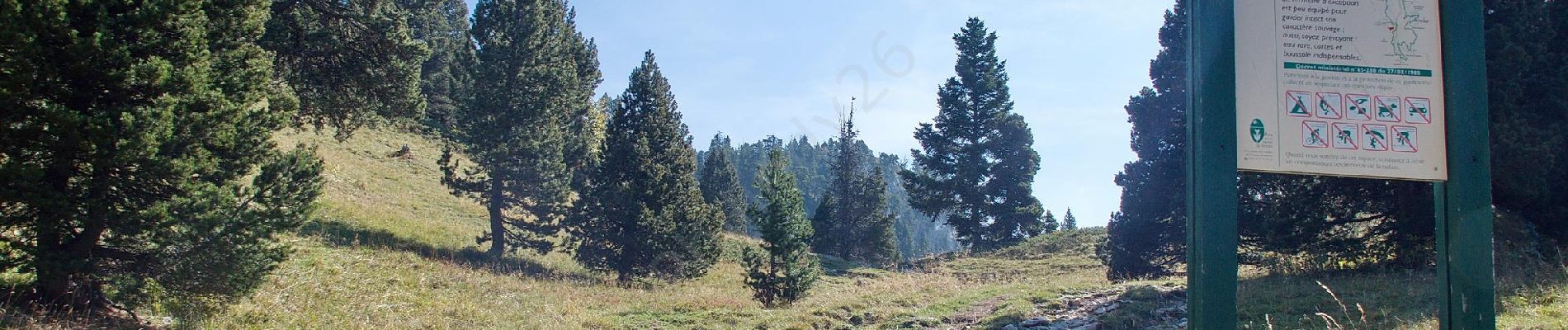
Attention : pensez à emporter suffisamment d'eau car il n'y en a très peu sur les hauts plateaux du Vercors.
Localisation
Commentaires
Randonnées à proximité
![Randonnée sport Die - Val croissant comptoir des moutons - Photo](https://media.geolcdn.com/t/375/260/3b919326-2e50-400f-bc15-c6be506dcde0.jpg&format=jpg&maxdim=2)
sport
![](/images/other/stat-length.png)
![](https://static1.geolcdn.com/siteimages/upload/files/16400158638029165_repeat_loop_refresh_sync_direction_icon.png)
![Randonnée Marche Die - Col de Bergu - Photo](https://media.geolcdn.com/t/375/260/cd646939-5ef5-44d1-b09a-be899a9a43a7.jpg&format=jpg&maxdim=2)
![Marche Marche](https://static1.geolcdn.com/sitytour/trail-icons/101.png)
Marche
![](/images/other/stat-length.png)
![](https://static1.geolcdn.com/siteimages/upload/files/16400158638029165_repeat_loop_refresh_sync_direction_icon.png)
![Randonnée Marche Die - Abbaye de Valcroissant - Photo](https://media.geolcdn.com/t/375/260/a9356d67-59c3-4251-97a5-c480f0ff70f4.jpg&format=jpg&maxdim=2)
![Marche Marche](https://static1.geolcdn.com/sitytour/trail-icons/101.png)
Marche
![](/images/other/stat-length.png)
![](https://static1.geolcdn.com/siteimages/upload/files/16400158638029165_repeat_loop_refresh_sync_direction_icon.png)
![Randonnée sport Die - Croix de Justin , Ausson - Photo](https://media.geolcdn.com/t/375/260/c8090ee5-5a94-4ee1-b2d3-2c37d8bd6d5e.jpg&format=jpg&maxdim=2)
sport
![](/images/other/stat-length.png)
![](https://static1.geolcdn.com/siteimages/upload/files/16400158638029165_repeat_loop_refresh_sync_direction_icon.png)
![Randonnée Marche Châtillon-en-Diois - Cabane de Chatillon - Photo](https://media.geolcdn.com/t/375/260/ea94f18f-fca1-490f-aab1-2356b5263731.jpg&format=jpg&maxdim=2)
![Marche Marche](https://static1.geolcdn.com/sitytour/trail-icons/101.png)
Marche
![](/images/other/stat-length.png)
![](https://static1.geolcdn.com/siteimages/upload/files/16400158638029165_repeat_loop_refresh_sync_direction_icon.png)
![Randonnée Marche Die - Tour Abbaye Val Croissant - Photo](https://media.geolcdn.com/t/375/260/a03f9356-ba67-4c89-83cb-2b5b84968cb8.jpg&format=jpg&maxdim=2)
![Marche Marche](https://static1.geolcdn.com/sitytour/trail-icons/101.png)
Marche
![](/images/other/stat-length.png)
![](https://static1.geolcdn.com/siteimages/upload/files/16400158638029165_repeat_loop_refresh_sync_direction_icon.png)
![Randonnée Marche Die - Abbaye Val croissant - Chatillon en diois - Photo](https://media.geolcdn.com/t/375/260/decff8a0-8389-400f-be19-ef575d278e3e.jpg&format=jpg&maxdim=2)
![Marche Marche](https://static1.geolcdn.com/sitytour/trail-icons/101.png)
Marche
![](/images/other/stat-length.png)
![](https://static1.geolcdn.com/siteimages/upload/files/16400158638029165_repeat_loop_refresh_sync_direction_icon.png)
![Randonnée Marche Die - Le Dôme ou Pié Ferré de l'Abbaye Valcroissant - Photo](https://media.geolcdn.com/t/375/260/3d8ae844-73e5-46a2-af4b-edc98cdca1a6.jpg&format=jpg&maxdim=2)
![Marche Marche](https://static1.geolcdn.com/sitytour/trail-icons/101.png)
Marche
![](/images/other/stat-length.png)
![](https://static1.geolcdn.com/siteimages/upload/files/16400158638029165_repeat_loop_refresh_sync_direction_icon.png)
![Randonnée Marche Die - Le Pestel - Photo](https://media.geolcdn.com/t/375/260/7b115de7-b12b-4372-8599-921e486c09f6.jpg&format=jpg&maxdim=2)
![Marche Marche](https://static1.geolcdn.com/sitytour/trail-icons/101.png)
Marche
![](/images/other/stat-length.png)
![](https://static1.geolcdn.com/siteimages/upload/files/16400158638029165_repeat_loop_refresh_sync_direction_icon.png)