05-BerlinerHtte-GreizerHtte SityTrail > Randonnées > Outdoor > Autriche > Tyrol > Bezirk Schwaz > Marktgemeinde Mayrhofen SityTrail > Randonnées > Outdoor > Autriche > Tyrol > Bezirk Schwaz > Marktgemeinde Mayrhofen 05-BerlinerHtte-GreizerHtte fpolini Utilisateur 3D © OpenStreetMap contributors Longueur 8,9 km Altitude max 2875 m Dénivelé positif 1224 m Km-Effort 25 km Altitude min 1803 m Dénivelé négatif 1056 m Boucle Non Date de création : 2019-06-08 19:24:52.979 Dernière modification : 2019-06-08 19:30:38.998 (0 Avis) Marche 4h47 Difficulté : Très difficile Application GPS de randonnée GRATUITE SityTrail IGN / Instituts géographiques SityTrail World Le monde est à vous À propos Randonnée Marche de 8,9 km à découvrir à Tyrol, Bezirk Schwaz, Marktgemeinde Mayrhofen. Cette randonnée est proposée par fpolini. Légendes | Plus de détails (PDF) Profil altimétrique Légendes > 15% 15% - 10% 10% - 5% à plat 5% - 10% 10% - 15% 15% - 30% > 30% Localisation Pays : Autriche Région : Tyrol Département/Province : Bezirk Schwaz Commune : Marktgemeinde Mayrhofen Localité : Unknown Départ:(Dec) 47.0246 / 11.81261 Départ:(UTM) 713726 ; 5211737 (32T) N. Commentaires Veuillez vous connecter pour laisser un commentaire ou une note Randonnées à proximité GUIDE+ IT-26 A pied Facile Ahrntal - Valle Aurina, Trentin-Haut-Adige, Haut-Adige, Italie 
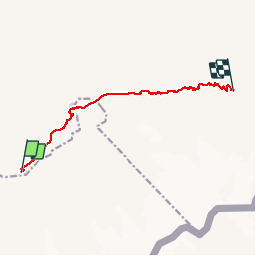
6,6 km | 11 km-effort 2h 29min Non fpolini 04-Furtschaglhaus-BerlinerHuette Marche Difficile Gemeinde Finkenberg, Tyrol, Bezirk Schwaz, Autriche 7,8 km | 20 km-effort 3h 47min Non