![](/images/other/stat-length.png)
![Randonnée Marche Saint-Romain-de-Popey - Les cerisiers de Saint Romain de Popey - Photo](https://media.geolcdn.com/t/1900/400/29b9bbfa-dc47-4a87-906f-96dd90692156.jpg&format=pjpeg&maxdim=2)
Les cerisiers de Saint Romain de Popey
Sigmut
Utilisateur
![Longueur](/images/other/stat-length.png)
Longueur
4,9 km
![Altitude max](https://static1.geolcdn.com/siteimages/upload/files/1508320355ic_sort_altitude_max_24dp.png)
Altitude max
593 m
![Dénivelé positif](https://static1.geolcdn.com/siteimages/upload/files/1508320355ic_sort_den_pos_24dp.png)
Dénivelé positif
219 m
![Km-Effort](/images/other/stat-length.png)
Km-Effort
7,8 km
![Altitude min](https://static1.geolcdn.com/siteimages/upload/files/1508320355ic_sort_altitude_min_24dp.png)
Altitude min
401 m
![Dénivelé négatif](https://static1.geolcdn.com/siteimages/upload/files/1508320355ic_sort_den_neg_24dp.png)
Dénivelé négatif
220 m
![Boucle](https://static1.geolcdn.com/siteimages/upload/files/16400158638029165_repeat_loop_refresh_sync_direction_icon.png)
Boucle
Oui
Date de création :
2019-06-08 10:33:00.126
Dernière modification :
2019-06-11 20:05:42.765
![Marche](https://static1.geolcdn.com/sitytour/trail-icons/101.png)
3h10
Difficulté : Facile
![Scannez ce code QR pour ouvrir la randonnée dans l'application SityTrail](https://capi.geolives.com/qq0zvz2zws4bq2lad0pu/sitytour/trails/2108117/qr.png?size=200)
Application GPS de randonnée GRATUITE
À propos
Randonnée Marche de 4,9 km à découvrir à Auvergne-Rhône-Alpes, Rhône, Saint-Romain-de-Popey. Cette randonnée est proposée par Sigmut.
Description
Randonnée facile et agréable avec beau point de vue effectuée en 3h10 avec un petit enfant de 4 ans et un autre de 2 ans et demi dans un sac à dos...
Localisation
Pays :
France
Région :
Auvergne-Rhône-Alpes
Département/Province :
Rhône
Commune :
Saint-Romain-de-Popey
Localité :
Unknown
Départ:(Dec)
Départ:(UTM)
618771 ; 5078161 (31T) N.
Commentaires
Randonnées à proximité
![Randonnée Marche Ancy - SityTrail - ANCY par les crêtes COURT - Photo](https://media.geolcdn.com/t/375/260/ext.jpg?maxdim=2&url=https%3A%2F%2Fstatic1.geolcdn.com%2Fsiteimages%2Fupload%2Ffiles%2F1553511878bg_sport_marche.png)
![Marche Marche](https://static1.geolcdn.com/sitytour/trail-icons/101.png)
SityTrail - ANCY par les crêtes COURT
Marche
Moyen
(1)
Ancy,
Auvergne-Rhône-Alpes,
Rhône,
France
![](/images/other/stat-length.png)
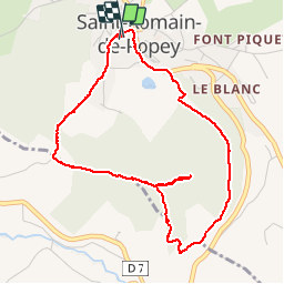
14 km | 20 km-effort
4h 39min
![](https://static1.geolcdn.com/siteimages/upload/files/16400158638029165_repeat_loop_refresh_sync_direction_icon.png)
Oui
![Randonnée Randonnée équestre Bully - BULLY nord 29k 38KF - Photo](https://media.geolcdn.com/t/375/260/ext.jpg?maxdim=2&url=https%3A%2F%2Fstatic1.geolcdn.com%2Fsiteimages%2Fupload%2Ffiles%2F1524743154cheval.jpg)
![Randonnée équestre Randonnée équestre](https://static1.geolcdn.com/sitytour/trail-icons/301.png)
BULLY nord 29k 38KF
Randonnée équestre
Difficile
(1)
Bully,
Auvergne-Rhône-Alpes,
Rhône,
France
![](/images/other/stat-length.png)
30 km | 39 km-effort
5h 9min
![](https://static1.geolcdn.com/siteimages/upload/files/16400158638029165_repeat_loop_refresh_sync_direction_icon.png)
Oui
![Randonnée Marche Ancy - Amicale_Ancy_12 - Photo](https://media.geolcdn.com/t/375/260/ext.jpg?maxdim=2&url=https%3A%2F%2Fstatic1.geolcdn.com%2Fsiteimages%2Fupload%2Ffiles%2F1553511878bg_sport_marche.png)
![Marche Marche](https://static1.geolcdn.com/sitytour/trail-icons/101.png)
Amicale_Ancy_12
Marche
Difficile
(1)
Ancy,
Auvergne-Rhône-Alpes,
Rhône,
France
![](/images/other/stat-length.png)
12,1 km | 17,4 km-effort
3h 57min
![](https://static1.geolcdn.com/siteimages/upload/files/16400158638029165_repeat_loop_refresh_sync_direction_icon.png)
Oui
![Randonnée Marche Bully - bully - Photo](https://media.geolcdn.com/t/375/260/ext.jpg?maxdim=2&url=https%3A%2F%2Fstatic1.geolcdn.com%2Fsiteimages%2Fupload%2Ffiles%2F1553511878bg_sport_marche.png)
![Marche Marche](https://static1.geolcdn.com/sitytour/trail-icons/101.png)
bully
Marche
Difficile
(1)
Bully,
Auvergne-Rhône-Alpes,
Rhône,
France
![](/images/other/stat-length.png)
10,7 km | 13,6 km-effort
2h 57min
![](https://static1.geolcdn.com/siteimages/upload/files/16400158638029165_repeat_loop_refresh_sync_direction_icon.png)
Oui
![Randonnée Marche Savigny - Savigny 9 km - Photo](https://media.geolcdn.com/t/375/260/4bd81ab3-ee45-493e-81df-f30878bb50c5.jpg&format=jpg&maxdim=2)
![Marche Marche](https://static1.geolcdn.com/sitytour/trail-icons/101.png)
Savigny 9 km
Marche
Difficile
(1)
Savigny,
Auvergne-Rhône-Alpes,
Rhône,
France
![](/images/other/stat-length.png)
9 km | 12,9 km-effort
2h 55min
![](https://static1.geolcdn.com/siteimages/upload/files/16400158638029165_repeat_loop_refresh_sync_direction_icon.png)
Oui
![Randonnée Vélo électrique Saint-Romain-de-Popey - matagrin du 19 mars - Photo](https://media.geolcdn.com/t/375/260/ext.jpg?maxdim=2&url=https%3A%2F%2Fservices.sitytrail.com%2FGeolivesWS%2FDownloadMedia.ashx%3FTrailID%3D926851%26Media%3Dfix__20180319132131.jpg)
![Vélo électrique Vélo électrique](https://static1.geolcdn.com/sitytour/trail-icons/205.png)
matagrin du 19 mars
Vélo électrique
Facile
Saint-Romain-de-Popey,
Auvergne-Rhône-Alpes,
Rhône,
France
![](/images/other/stat-length.png)
45 km | 64 km-effort
Inconnu
![](https://static1.geolcdn.com/siteimages/upload/files/16400158638029165_repeat_loop_refresh_sync_direction_icon.png)
Non
![Randonnée Marche Saint-Forgeux - Randonnée de Saint Forgeux à Ronzière - Photo](https://media.geolcdn.com/t/375/260/ext.jpg?maxdim=2&url=https%3A%2F%2Fservices.sitytrail.com%2FGeolivesWS%2FDownloadMedia.ashx%3FTrailID%3D109913%26Media%3D4928_2.jpg)
![Marche Marche](https://static1.geolcdn.com/sitytour/trail-icons/101.png)
Randonnée de Saint Forgeux à Ronzière
Marche
Difficile
Saint-Forgeux,
Auvergne-Rhône-Alpes,
Rhône,
France
![](/images/other/stat-length.png)
11,2 km | 16,8 km-effort
3h 0min
![](https://static1.geolcdn.com/siteimages/upload/files/16400158638029165_repeat_loop_refresh_sync_direction_icon.png)
Oui
![Randonnée Marche Savigny - Savigny Trésoncle - Photo](https://media.geolcdn.com/t/375/260/ext.jpg?maxdim=2&url=https%3A%2F%2Fstatic1.geolcdn.com%2Fsiteimages%2Fupload%2Ffiles%2F1553511878bg_sport_marche.png)
![Marche Marche](https://static1.geolcdn.com/sitytour/trail-icons/101.png)
Savigny Trésoncle
Marche
Facile
Savigny,
Auvergne-Rhône-Alpes,
Rhône,
France
![](/images/other/stat-length.png)
9,8 km | 13,6 km-effort
2h 53min
![](https://static1.geolcdn.com/siteimages/upload/files/16400158638029165_repeat_loop_refresh_sync_direction_icon.png)
Oui
![Randonnée Marche Saint-Julien-sur-Bibost - Saint julien sur bibost - Photo](https://media.geolcdn.com/t/375/260/ext.jpg?maxdim=2&url=https%3A%2F%2Fstatic1.geolcdn.com%2Fsiteimages%2Fupload%2Ffiles%2F1553511878bg_sport_marche.png)
![Marche Marche](https://static1.geolcdn.com/sitytour/trail-icons/101.png)
Saint julien sur bibost
Marche
Moyen
Saint-Julien-sur-Bibost,
Auvergne-Rhône-Alpes,
Rhône,
France
![](/images/other/stat-length.png)
24 km | 35 km-effort
5h 44min
![](https://static1.geolcdn.com/siteimages/upload/files/16400158638029165_repeat_loop_refresh_sync_direction_icon.png)
Non