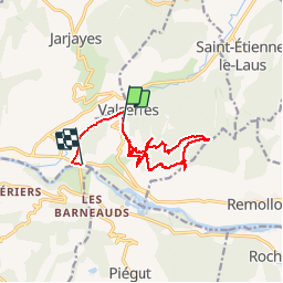
![](/images/other/stat-length.png)
![Randonnée Marche Valserres - Chapelle Saint Maurice. - Photo](https://media.geolcdn.com/t/1900/400/0a473682-9b70-4f19-aaa2-260640970212.jpg&format=pjpeg&maxdim=2)
Chapelle Saint Maurice.
Dervalmarc
Utilisateur
![Longueur](/images/other/stat-length.png)
![Altitude max](https://static1.geolcdn.com/siteimages/upload/files/1508320355ic_sort_altitude_max_24dp.png)
![Dénivelé positif](https://static1.geolcdn.com/siteimages/upload/files/1508320355ic_sort_den_pos_24dp.png)
![Km-Effort](/images/other/stat-length.png)
![Altitude min](https://static1.geolcdn.com/siteimages/upload/files/1508320355ic_sort_altitude_min_24dp.png)
![Dénivelé négatif](https://static1.geolcdn.com/siteimages/upload/files/1508320355ic_sort_den_neg_24dp.png)
![Boucle](https://static1.geolcdn.com/siteimages/upload/files/16400158638029165_repeat_loop_refresh_sync_direction_icon.png)
![Marche](https://static1.geolcdn.com/sitytour/trail-icons/101.png)
3h51
Difficulté : Moyen
![Scannez ce code QR pour ouvrir la randonnée dans l'application SityTrail](https://capi.geolives.com/qq0zvz2zws4bq2lad0pu/sitytour/trails/2102685/qr.png?size=200)
Application GPS de randonnée GRATUITE
À propos
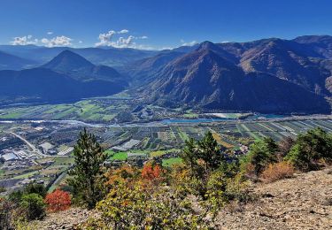
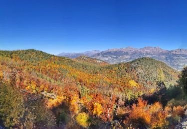
Randonnée Marche de 12,9 km à découvrir à Provence-Alpes-Côte d'Azur, Hautes-Alpes, Valserres. Cette randonnée est proposée par Dervalmarc.
Description
Attention randonnée très mal balise.
Suivre bien les quelques cairns aux intersections de la piste.
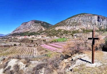
Privilégier la piste à la montée.
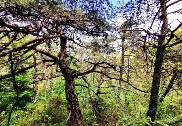
Le sentier rando très raide avec des pentes à plus de 40 pour cent.
Prudence à la descente surtout s'il a plu.
Rando sportive de moyen à difficile.
Localisation
Commentaires
Randonnées à proximité
![Randonnée Marche Jarjayes - VALSAIRES CHAPELLE NOTRE DAME DU LAIS - Photo](https://media.geolcdn.com/t/375/260/860e51d5-4111-42e4-9649-8920f6056baf.jpg&format=jpg&maxdim=2)
![Marche Marche](https://static1.geolcdn.com/sitytour/trail-icons/101.png)
Marche
![](/images/other/stat-length.png)
![](https://static1.geolcdn.com/siteimages/upload/files/16400158638029165_repeat_loop_refresh_sync_direction_icon.png)
![Randonnée Marche Remollon - Remollon : Un Trésor Caché de la Vallée de la Durance - Photo](https://media.geolcdn.com/t/375/260/073a624b-9a54-4ca5-a179-7003c0d6383d.jpg&format=jpg&maxdim=2)
![Marche Marche](https://static1.geolcdn.com/sitytour/trail-icons/101.png)
Marche
![](/images/other/stat-length.png)
![](https://static1.geolcdn.com/siteimages/upload/files/16400158638029165_repeat_loop_refresh_sync_direction_icon.png)
![Randonnée Marche Remollon - Des Demoiselles Coiffées aux balcons de Remollon - Photo](https://media.geolcdn.com/t/375/260/2094a0e8-535c-4f81-bf59-f1f898a15092.jpg&format=jpg&maxdim=2)
![Marche Marche](https://static1.geolcdn.com/sitytour/trail-icons/101.png)
Marche
![](/images/other/stat-length.png)
![](https://static1.geolcdn.com/siteimages/upload/files/16400158638029165_repeat_loop_refresh_sync_direction_icon.png)
![Randonnée Vélo électrique Remollon - Le Puy et la Chapelle Saint-Sixte Via Remollon (Vélo) - Photo](https://media.geolcdn.com/t/375/260/9848f8cc-dc59-4eb7-862a-9f5bf908e081.jpg&format=jpg&maxdim=2)
![Vélo électrique Vélo électrique](https://static1.geolcdn.com/sitytour/trail-icons/205.png)
Vélo électrique
![](/images/other/stat-length.png)
![](https://static1.geolcdn.com/siteimages/upload/files/16400158638029165_repeat_loop_refresh_sync_direction_icon.png)
![Randonnée Marche Tallard - TALLARD tête de Boursier o m s - Photo](https://media.geolcdn.com/t/375/260/ee8e87fe-5cd1-4067-9cf8-9a025ecb47fe.jpg&format=jpg&maxdim=2)
![Marche Marche](https://static1.geolcdn.com/sitytour/trail-icons/101.png)
Marche
![](/images/other/stat-length.png)
![](https://static1.geolcdn.com/siteimages/upload/files/16400158638029165_repeat_loop_refresh_sync_direction_icon.png)
![Randonnée Vélo électrique Remollon - VTT-ae - Mont Colombis via Valserres - Croix des prés - Photo](https://media.geolcdn.com/t/375/260/cae6d5f9-a8e8-4077-ab5a-04e6867e007f.jpg&format=jpg&maxdim=2)
![Vélo électrique Vélo électrique](https://static1.geolcdn.com/sitytour/trail-icons/205.png)
Vélo électrique
![](/images/other/stat-length.png)
![](https://static1.geolcdn.com/siteimages/upload/files/16400158638029165_repeat_loop_refresh_sync_direction_icon.png)
![Randonnée V.T.T. Remollon - VTT-ae - La Croix des Prés avec V&H - Photo](https://media.geolcdn.com/t/375/260/9b08ae67-d798-4978-a9ac-e62d1c938cfe.jpg&format=jpg&maxdim=2)
![V.T.T. V.T.T.](https://static1.geolcdn.com/sitytour/trail-icons/202.png)
V.T.T.
![](/images/other/stat-length.png)
![](https://static1.geolcdn.com/siteimages/upload/files/16400158638029165_repeat_loop_refresh_sync_direction_icon.png)
![Randonnée Marche Piégut - Tour du ravin de Neyrac Via Piégut - Photo](https://media.geolcdn.com/t/375/260/f436686e-fd78-43e7-89bc-7db0374b15b6.jpg&format=jpg&maxdim=2)
![Marche Marche](https://static1.geolcdn.com/sitytour/trail-icons/101.png)
Marche
![](/images/other/stat-length.png)
![](https://static1.geolcdn.com/siteimages/upload/files/16400158638029165_repeat_loop_refresh_sync_direction_icon.png)
![Randonnée Marche Remollon - REMOLON Les demoiselles coiffées, Chapelle S Philippine .Tueuse o n l - Photo](https://media.geolcdn.com/t/375/260/0cbb9a09-f191-4c7c-af26-e28f897b633e.jpg&format=jpg&maxdim=2)
![Marche Marche](https://static1.geolcdn.com/sitytour/trail-icons/101.png)
Marche
![](/images/other/stat-length.png)
![](https://static1.geolcdn.com/siteimages/upload/files/16400158638029165_repeat_loop_refresh_sync_direction_icon.png)