![](/images/other/stat-length.png)
![Randonnée Marche Péreyres - Pereyres - Le Ray-Pic 1/6/2019 - Photo](https://media.geolcdn.com/t/1900/400/ext.pjpeg?maxdim=2&url=https%3A%2F%2Fstatic1.geolcdn.com%2Fsiteimages%2Fupload%2Ffiles%2F1553511878bg_sport_marche.png)
Pereyres - Le Ray-Pic 1/6/2019
fredetpascale
Utilisateur GUIDE
![Longueur](/images/other/stat-length.png)
Longueur
9,1 km
![Altitude max](https://static1.geolcdn.com/siteimages/upload/files/1508320355ic_sort_altitude_max_24dp.png)
Altitude max
1063 m
![Dénivelé positif](https://static1.geolcdn.com/siteimages/upload/files/1508320355ic_sort_den_pos_24dp.png)
Dénivelé positif
431 m
![Km-Effort](/images/other/stat-length.png)
Km-Effort
14,8 km
![Altitude min](https://static1.geolcdn.com/siteimages/upload/files/1508320355ic_sort_altitude_min_24dp.png)
Altitude min
790 m
![Dénivelé négatif](https://static1.geolcdn.com/siteimages/upload/files/1508320355ic_sort_den_neg_24dp.png)
Dénivelé négatif
430 m
![Boucle](https://static1.geolcdn.com/siteimages/upload/files/16400158638029165_repeat_loop_refresh_sync_direction_icon.png)
Boucle
Oui
Date de création :
2019-06-01 08:33:42.932
Dernière modification :
2019-06-01 14:14:03.978
![Marche](https://static1.geolcdn.com/sitytour/trail-icons/101.png)
3h24
Difficulté : Facile
![Scannez ce code QR pour ouvrir la randonnée dans l'application SityTrail](https://capi.geolives.com/qq0zvz2zws4bq2lad0pu/sitytour/trails/2101053/qr.png?size=200)
Application GPS de randonnée GRATUITE
À propos
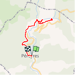
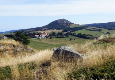
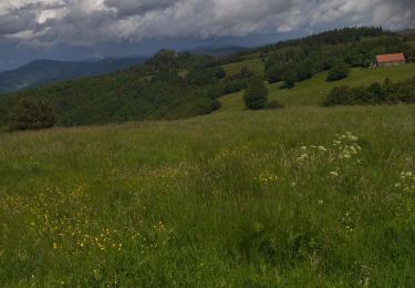
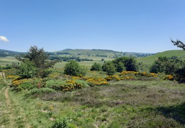
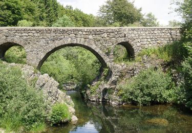
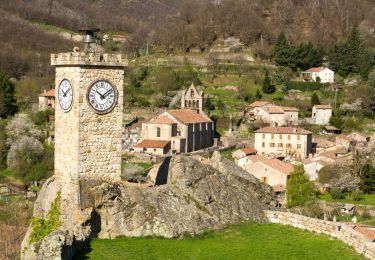
Randonnée Marche de 9,1 km à découvrir à Auvergne-Rhône-Alpes, Ardèche, Péreyres. Cette randonnée est proposée par fredetpascale.
Description
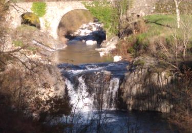
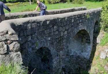
accès cascade interdit mais tout le monde passe. Pas de risque de chute de pierre si on ne fait que les belvédères.
Localisation
Pays :
France
Région :
Auvergne-Rhône-Alpes
Département/Province :
Ardèche
Commune :
Péreyres
Localité :
Unknown
Départ:(Dec)
Départ:(UTM)
599380 ; 4958897 (31T) N.
Commentaires
Randonnées à proximité
![Randonnée Marche Péreyres - Pereyres Lachamp 16km - Photo](https://media.geolcdn.com/t/375/260/cd059db4-0e57-4cdd-b0a7-57f5a9d765a9.jpg&format=jpg&maxdim=2)
![Marche Marche](https://static1.geolcdn.com/sitytour/trail-icons/101.png)
Pereyres Lachamp 16km
Marche
Moyen
Péreyres,
Auvergne-Rhône-Alpes,
Ardèche,
France
![](/images/other/stat-length.png)
16,1 km | 24 km-effort
5h 32min
![](https://static1.geolcdn.com/siteimages/upload/files/16400158638029165_repeat_loop_refresh_sync_direction_icon.png)
Oui
![Randonnée Marche Lachamp-Raphaël - 07 lachamp Raphaël orga 10.06.23 - Photo](https://media.geolcdn.com/t/375/260/07456a0b-3bda-48f2-bd40-fb46d8070303.jpg&format=jpg&maxdim=2)
![Marche Marche](https://static1.geolcdn.com/sitytour/trail-icons/101.png)
07 lachamp Raphaël orga 10.06.23
Marche
Moyen
Lachamp-Raphaël,
Auvergne-Rhône-Alpes,
Ardèche,
France
![](/images/other/stat-length.png)
18 km | 27 km-effort
5h 39min
![](https://static1.geolcdn.com/siteimages/upload/files/16400158638029165_repeat_loop_refresh_sync_direction_icon.png)
Non
![Randonnée Marche Sagnes-et-Goudoulet - Les Coux-Sagnes-Tour à Eau 14km - Photo](https://media.geolcdn.com/t/375/260/7bfff9d7-91a3-4852-a6bf-dd6f46240ce8.jpg&format=jpg&maxdim=2)
![Marche Marche](https://static1.geolcdn.com/sitytour/trail-icons/101.png)
Les Coux-Sagnes-Tour à Eau 14km
Marche
Moyen
Sagnes-et-Goudoulet,
Auvergne-Rhône-Alpes,
Ardèche,
France
![](/images/other/stat-length.png)
14,1 km | 19,4 km-effort
5h 42min
![](https://static1.geolcdn.com/siteimages/upload/files/16400158638029165_repeat_loop_refresh_sync_direction_icon.png)
Oui
![Randonnée Marche Saint-Andéol-de-Fourchades - Boucle de la ferme de Bourdalier à Sagnes-et-Gourdoulet - Photo](https://media.geolcdn.com/t/375/260/31c1868a-b2a8-47e4-b863-8b44b5da618e.jpg&format=jpg&maxdim=2)
![Marche Marche](https://static1.geolcdn.com/sitytour/trail-icons/101.png)
Boucle de la ferme de Bourdalier à Sagnes-et-Gourdoulet
Marche
Moyen
Saint-Andéol-de-Fourchades,
Auvergne-Rhône-Alpes,
Ardèche,
France
![](/images/other/stat-length.png)
11,7 km | 15,8 km-effort
3h 35min
![](https://static1.geolcdn.com/siteimages/upload/files/16400158638029165_repeat_loop_refresh_sync_direction_icon.png)
Oui
![Randonnée Marche Burzet - Burzet (Myrtille) - Photo](https://media.geolcdn.com/t/375/260/b806d2dc-fc2d-46e9-8fd4-c0cb1135c85b.jpg&format=jpg&maxdim=2)
![Marche Marche](https://static1.geolcdn.com/sitytour/trail-icons/101.png)
Burzet (Myrtille)
Marche
Facile
Burzet,
Auvergne-Rhône-Alpes,
Ardèche,
France
![](/images/other/stat-length.png)
6,7 km | 10,1 km-effort
2h 8min
![](https://static1.geolcdn.com/siteimages/upload/files/16400158638029165_repeat_loop_refresh_sync_direction_icon.png)
Oui
![Randonnée Marche Burzet - Burzet - Peyreyres a/r - Photo](https://media.geolcdn.com/t/375/260/23473f45-0263-4dae-8985-6a6cd9c5506f.jpg&format=jpg&maxdim=2)
![Marche Marche](https://static1.geolcdn.com/sitytour/trail-icons/101.png)
Burzet - Peyreyres a/r
Marche
Très difficile
Burzet,
Auvergne-Rhône-Alpes,
Ardèche,
France
![](/images/other/stat-length.png)
12,8 km | 19,4 km-effort
4h 23min
![](https://static1.geolcdn.com/siteimages/upload/files/16400158638029165_repeat_loop_refresh_sync_direction_icon.png)
Oui
![Randonnée Marche Sagnes-et-Goudoulet - Les Coux - Sagne et Goudoulet - La Tour à Eau 14km - Photo](https://media.geolcdn.com/t/375/260/e50b9160-d833-4b37-8588-2eb7f9e44f6b.jpg&format=jpg&maxdim=2)
![Marche Marche](https://static1.geolcdn.com/sitytour/trail-icons/101.png)
Les Coux - Sagne et Goudoulet - La Tour à Eau 14km
Marche
Difficile
Sagnes-et-Goudoulet,
Auvergne-Rhône-Alpes,
Ardèche,
France
![](/images/other/stat-length.png)
14,2 km | 19,6 km-effort
5h 36min
![](https://static1.geolcdn.com/siteimages/upload/files/16400158638029165_repeat_loop_refresh_sync_direction_icon.png)
Oui
![Randonnée Marche Burzet - Burzet Péreyres 17km - Photo](https://media.geolcdn.com/t/375/260/ce9bedc1-acaa-4ec8-8551-b33be3b18c1c.jpg&format=jpg&maxdim=2)
![Marche Marche](https://static1.geolcdn.com/sitytour/trail-icons/101.png)
Burzet Péreyres 17km
Marche
Difficile
Burzet,
Auvergne-Rhône-Alpes,
Ardèche,
France
![](/images/other/stat-length.png)
16,9 km | 28 km-effort
6h 24min
![](https://static1.geolcdn.com/siteimages/upload/files/16400158638029165_repeat_loop_refresh_sync_direction_icon.png)
Oui
![Randonnée Marche Lachamp-Raphaël - Lachamp-Raphaël : les sucs - Photo](https://media.geolcdn.com/t/375/260/efd94835-0c85-498e-997c-3f10de9c1e49.jpg&format=jpg&maxdim=2)
![Marche Marche](https://static1.geolcdn.com/sitytour/trail-icons/101.png)
Lachamp-Raphaël : les sucs
Marche
Moyen
Lachamp-Raphaël,
Auvergne-Rhône-Alpes,
Ardèche,
France
![](/images/other/stat-length.png)
23 km | 31 km-effort
5h 18min
![](https://static1.geolcdn.com/siteimages/upload/files/16400158638029165_repeat_loop_refresh_sync_direction_icon.png)
Oui