![](/images/other/stat-length.png)
![Randonnée Randonnée à dos d'âne Port-la-Nouvelle - Cathare 1 port la nouvelle Durban Corbieres - Photo](https://media.geolcdn.com/t/1900/400/e41ebe21-8688-4101-9289-802a8715a742.jpg&format=pjpeg&maxdim=2)
Cathare 1 port la nouvelle Durban Corbieres
jeff2
Utilisateur
![Longueur](/images/other/stat-length.png)
Longueur
20 km
![Altitude max](https://static1.geolcdn.com/siteimages/upload/files/1508320355ic_sort_altitude_max_24dp.png)
Altitude max
297 m
![Dénivelé positif](https://static1.geolcdn.com/siteimages/upload/files/1508320355ic_sort_den_pos_24dp.png)
Dénivelé positif
484 m
![Km-Effort](/images/other/stat-length.png)
Km-Effort
26 km
![Altitude min](https://static1.geolcdn.com/siteimages/upload/files/1508320355ic_sort_altitude_min_24dp.png)
Altitude min
19 m
![Dénivelé négatif](https://static1.geolcdn.com/siteimages/upload/files/1508320355ic_sort_den_neg_24dp.png)
Dénivelé négatif
248 m
![Boucle](https://static1.geolcdn.com/siteimages/upload/files/16400158638029165_repeat_loop_refresh_sync_direction_icon.png)
Boucle
Non
Date de création :
2019-05-31 05:46:09.876
Dernière modification :
2019-05-31 16:30:13.399
![Randonnée à dos d'âne](https://static1.geolcdn.com/sitytour/trail-icons/303.png)
4h21
Difficulté : Moyen
![Scannez ce code QR pour ouvrir la randonnée dans l'application SityTrail](https://capi.geolives.com/qq0zvz2zws4bq2lad0pu/sitytour/trails/2100251/qr.png?size=200)
Application GPS de randonnée GRATUITE
À propos
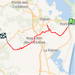
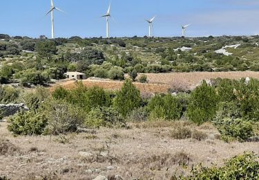
Randonnée Randonnée à dos d'âne de 20 km à découvrir à Occitanie, Aude, Port-la-Nouvelle. Cette randonnée est proposée par jeff2.
Description
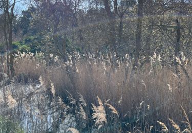
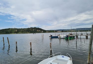
1ere étape problème de telephone et de batterie externe. Le GPS a donc tiré une ligne droite. Je pense 27 kms aujourd'hui. Les gens du coin disent 34° aujourd'hui et pire demain...
Je vais partir vers 6 heure demain matin...
Localisation
Pays :
France
Région :
Occitanie
Département/Province :
Aude
Commune :
Port-la-Nouvelle
Localité :
Unknown
Départ:(Dec)
Départ:(UTM)
502760 ; 4762285 (31T) N.
Commentaires
Randonnées à proximité
![Randonnée Marche La Palme - La palme 17_09_2020 - Photo](https://media.geolcdn.com/t/375/260/d7f347aa-f418-4dc5-9ccc-da38c1b77565.jpg&format=jpg&maxdim=2)
![Marche Marche](https://static1.geolcdn.com/sitytour/trail-icons/101.png)
La palme 17_09_2020
Marche
Très facile
(2)
La Palme,
Occitanie,
Aude,
France
![](/images/other/stat-length.png)
7,5 km | 8,9 km-effort
1h 51min
![](https://static1.geolcdn.com/siteimages/upload/files/16400158638029165_repeat_loop_refresh_sync_direction_icon.png)
Oui
![Randonnée A pied Sigean - Boucle des Cabanes de Port Mahon Sigean - Photo](https://media.geolcdn.com/t/375/260/ext.jpg?maxdim=2&url=https%3A%2F%2Fstatic1.geolcdn.com%2Fsiteimages%2Fupload%2Ffiles%2F1545311037marcheuse_200dpi.jpg)
![A pied A pied](https://static1.geolcdn.com/sitytour/trail-icons/100.png)
Boucle des Cabanes de Port Mahon Sigean
A pied
Moyen
(1)
Sigean,
Occitanie,
Aude,
France
![](/images/other/stat-length.png)
12,4 km | 13,9 km-effort
3h 20min
![](https://static1.geolcdn.com/siteimages/upload/files/16400158638029165_repeat_loop_refresh_sync_direction_icon.png)
Oui
![Randonnée Marche Port-la-Nouvelle - Port la nouvelle - Photo](https://media.geolcdn.com/t/375/260/b6313dc6-a7e0-4f0e-bceb-1493c2dc6087.jpg&format=jpg&maxdim=2)
![Marche Marche](https://static1.geolcdn.com/sitytour/trail-icons/101.png)
Port la nouvelle
Marche
Facile
Port-la-Nouvelle,
Occitanie,
Aude,
France
![](/images/other/stat-length.png)
11,9 km | 13,1 km-effort
4h 58min
![](https://static1.geolcdn.com/siteimages/upload/files/16400158638029165_repeat_loop_refresh_sync_direction_icon.png)
Oui
![Randonnée Marche Port-la-Nouvelle - Port la nouvelle - Photo](https://media.geolcdn.com/t/375/260/4650213f-f303-4d9e-b2fa-13ce36bb8422.jpg&format=jpg&maxdim=2)
![Marche Marche](https://static1.geolcdn.com/sitytour/trail-icons/101.png)
Port la nouvelle
Marche
Facile
Port-la-Nouvelle,
Occitanie,
Aude,
France
![](/images/other/stat-length.png)
13,4 km | 14,7 km-effort
3h 29min
![](https://static1.geolcdn.com/siteimages/upload/files/16400158638029165_repeat_loop_refresh_sync_direction_icon.png)
Oui
![Randonnée Marche La Palme - la palme la jasse - Photo](https://media.geolcdn.com/t/375/260/0ee72d9c-a841-4e90-9113-9fdf47558874.jpg&format=jpg&maxdim=2)
![Marche Marche](https://static1.geolcdn.com/sitytour/trail-icons/101.png)
la palme la jasse
Marche
Difficile
La Palme,
Occitanie,
Aude,
France
![](/images/other/stat-length.png)
13,1 km | 15,2 km-effort
6h 25min
![](https://static1.geolcdn.com/siteimages/upload/files/16400158638029165_repeat_loop_refresh_sync_direction_icon.png)
Oui
![Randonnée Marche Sigean - port mabon - Photo](https://media.geolcdn.com/t/375/260/8dffe964-f9eb-480b-bba3-e465a645cce6.jpg&format=jpg&maxdim=2)
![Marche Marche](https://static1.geolcdn.com/sitytour/trail-icons/101.png)
![Randonnée Marche Sigean - Les Salins de Sigean - Photo](https://media.geolcdn.com/t/375/260/0c3906c1-ddca-4889-b150-1015072c6404.jpg&format=jpg&maxdim=2)
![Marche Marche](https://static1.geolcdn.com/sitytour/trail-icons/101.png)
Les Salins de Sigean
Marche
Facile
Sigean,
Occitanie,
Aude,
France
![](/images/other/stat-length.png)
15,6 km | 17,6 km-effort
4h 30min
![](https://static1.geolcdn.com/siteimages/upload/files/16400158638029165_repeat_loop_refresh_sync_direction_icon.png)
Oui
![Randonnée V.T.T. Port-la-Nouvelle - Boucle de Bages d Aude - Photo](https://media.geolcdn.com/t/375/260/a01030c1-d4b4-447f-a4d0-03c1eec8e654.jpg&format=jpg&maxdim=2)
![V.T.T. V.T.T.](https://static1.geolcdn.com/sitytour/trail-icons/202.png)
Boucle de Bages d Aude
V.T.T.
Moyen
Port-la-Nouvelle,
Occitanie,
Aude,
France
![](/images/other/stat-length.png)
67 km | 72 km-effort
Inconnu
![](https://static1.geolcdn.com/siteimages/upload/files/16400158638029165_repeat_loop_refresh_sync_direction_icon.png)
Oui
![Randonnée V.T.T. Port-la-Nouvelle - Port la Nouvelle ( parking île Ste Lucie ) Bages d 'Aude - Photo](https://media.geolcdn.com/t/375/260/5bfa458c-6110-4868-b219-6b44500d4cf8.jpg&format=jpg&maxdim=2)
![V.T.T. V.T.T.](https://static1.geolcdn.com/sitytour/trail-icons/202.png)
Port la Nouvelle ( parking île Ste Lucie ) Bages d 'Aude
V.T.T.
Très difficile
Port-la-Nouvelle,
Occitanie,
Aude,
France
![](/images/other/stat-length.png)
65 km | 70 km-effort
6h 32min
![](https://static1.geolcdn.com/siteimages/upload/files/16400158638029165_repeat_loop_refresh_sync_direction_icon.png)
Oui