![](/images/other/stat-length.png)
![Randonnée Marche Saint-Paul-de-Fenouillet - galamus - Photo](https://media.geolcdn.com/t/1900/400/43b242c2-1589-4250-8648-9cdec5eecdaa.jpg&format=pjpeg&maxdim=2)
galamus
cappelle
Utilisateur
![Longueur](/images/other/stat-length.png)
Longueur
16,8 km
![Altitude max](https://static1.geolcdn.com/siteimages/upload/files/1508320355ic_sort_altitude_max_24dp.png)
Altitude max
919 m
![Dénivelé positif](https://static1.geolcdn.com/siteimages/upload/files/1508320355ic_sort_den_pos_24dp.png)
Dénivelé positif
844 m
![Km-Effort](/images/other/stat-length.png)
Km-Effort
28 km
![Altitude min](https://static1.geolcdn.com/siteimages/upload/files/1508320355ic_sort_altitude_min_24dp.png)
Altitude min
322 m
![Dénivelé négatif](https://static1.geolcdn.com/siteimages/upload/files/1508320355ic_sort_den_neg_24dp.png)
Dénivelé négatif
843 m
![Boucle](https://static1.geolcdn.com/siteimages/upload/files/16400158638029165_repeat_loop_refresh_sync_direction_icon.png)
Boucle
Oui
Date de création :
2019-05-21 07:45:47.382
Dernière modification :
2019-05-22 06:55:21.079
![Marche](https://static1.geolcdn.com/sitytour/trail-icons/101.png)
7h30
Difficulté : Moyen
![Scannez ce code QR pour ouvrir la randonnée dans l'application SityTrail](https://capi.geolives.com/qq0zvz2zws4bq2lad0pu/sitytour/trails/2090337/qr.png?size=200)
Application GPS de randonnée GRATUITE
À propos
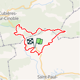
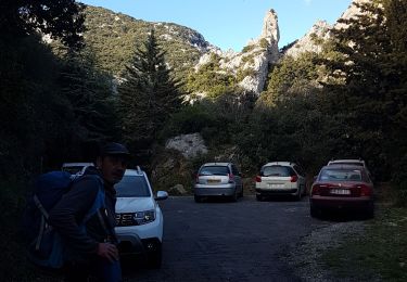
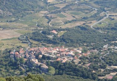
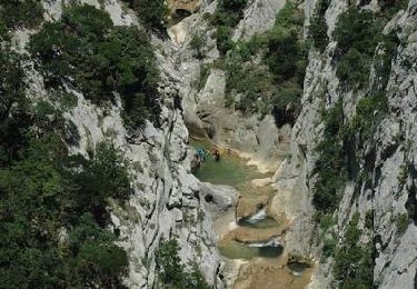
Randonnée Marche de 16,8 km à découvrir à Occitanie, Pyrénées-Orientales, Saint-Paul-de-Fenouillet. Cette randonnée est proposée par cappelle.
Description
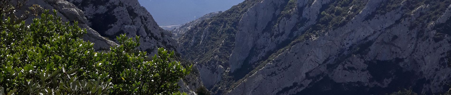
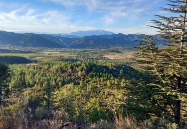
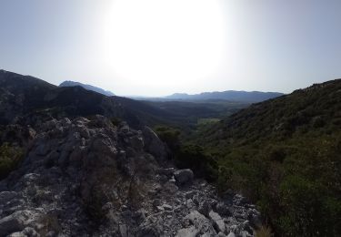
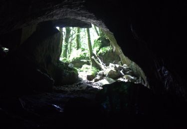
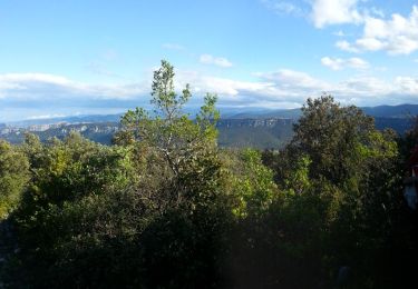
belle rando avec de tres belles vue sur les Pyrénées et la vallée , les gorges sont superbes , montée difficile pour randonneur peu entrainé .
IBP index 79
Localisation
Pays :
France
Région :
Occitanie
Département/Province :
Pyrénées-Orientales
Commune :
Saint-Paul-de-Fenouillet
Localité :
Unknown
Départ:(Dec)
Départ:(UTM)
458384 ; 4742683 (31T) N.
Commentaires
Randonnées à proximité
![Randonnée Marche Saint-Paul-de-Fenouillet - Ermitage de Galamus - Photo](https://media.geolcdn.com/t/375/260/46039162-6164-4640-a304-ccd455d5027d.jpg&format=jpg&maxdim=2)
![Marche Marche](https://static1.geolcdn.com/sitytour/trail-icons/101.png)
Ermitage de Galamus
Marche
Facile
Saint-Paul-de-Fenouillet,
Occitanie,
Pyrénées-Orientales,
France
![](/images/other/stat-length.png)
1,3 km | 2,3 km-effort
26min
![](https://static1.geolcdn.com/siteimages/upload/files/16400158638029165_repeat_loop_refresh_sync_direction_icon.png)
Oui
![Randonnée Marche Saint-Paul-de-Fenouillet - La Quille - Photo](https://media.geolcdn.com/t/375/260/47f7336c-3219-4083-bfb3-c8b198d14d48.jpg&format=jpg&maxdim=2)
![Marche Marche](https://static1.geolcdn.com/sitytour/trail-icons/101.png)
La Quille
Marche
Très difficile
Saint-Paul-de-Fenouillet,
Occitanie,
Pyrénées-Orientales,
France
![](/images/other/stat-length.png)
16,9 km | 29 km-effort
6h 23min
![](https://static1.geolcdn.com/siteimages/upload/files/16400158638029165_repeat_loop_refresh_sync_direction_icon.png)
Non
![Randonnée Marche Saint-Paul-de-Fenouillet - Autour des gorges de Galamus - Photo](https://media.geolcdn.com/t/375/260/ebb1bc80-1a1f-4b07-90dd-5976415c2a9f.jpg&format=jpg&maxdim=2)
![Marche Marche](https://static1.geolcdn.com/sitytour/trail-icons/101.png)
Autour des gorges de Galamus
Marche
Très difficile
Saint-Paul-de-Fenouillet,
Occitanie,
Pyrénées-Orientales,
France
![](/images/other/stat-length.png)
12,4 km | 22 km-effort
6h 28min
![](https://static1.geolcdn.com/siteimages/upload/files/16400158638029165_repeat_loop_refresh_sync_direction_icon.png)
Oui
![Randonnée Marche Prugnanes - roc paradet - Photo](https://media.geolcdn.com/t/375/260/f4e6fd12-f0ab-4601-9b76-44d15e72f3de.jpg&format=jpg&maxdim=2)
![Marche Marche](https://static1.geolcdn.com/sitytour/trail-icons/101.png)
roc paradet
Marche
Très difficile
Prugnanes,
Occitanie,
Pyrénées-Orientales,
France
![](/images/other/stat-length.png)
11,3 km | 19,4 km-effort
5h 58min
![](https://static1.geolcdn.com/siteimages/upload/files/16400158638029165_repeat_loop_refresh_sync_direction_icon.png)
Oui
![Randonnée Marche Saint-Paul-de-Fenouillet - st Paul de fenouinlet / col lenty et retour - Photo](https://media.geolcdn.com/t/375/260/281156ab-3036-4fe8-93da-4a2eaadc40df.jpg&format=jpg&maxdim=2)
![Marche Marche](https://static1.geolcdn.com/sitytour/trail-icons/101.png)
st Paul de fenouinlet / col lenty et retour
Marche
Difficile
Saint-Paul-de-Fenouillet,
Occitanie,
Pyrénées-Orientales,
France
![](/images/other/stat-length.png)
9,6 km | 15,6 km-effort
2h 59min
![](https://static1.geolcdn.com/siteimages/upload/files/16400158638029165_repeat_loop_refresh_sync_direction_icon.png)
Oui
![Randonnée Marche Prugnanes - Prugnanes Roc Paradet - Photo](https://media.geolcdn.com/t/375/260/ext.jpg?maxdim=2&url=https%3A%2F%2Fservices.sitytrail.com%2FGeolivesWS%2FDownloadMedia.ashx%3FTrailID%3D327912%26Media%3Dfix__20140723095802.jpg)
![Marche Marche](https://static1.geolcdn.com/sitytour/trail-icons/101.png)
Prugnanes Roc Paradet
Marche
Moyen
Prugnanes,
Occitanie,
Pyrénées-Orientales,
France
![](/images/other/stat-length.png)
11,2 km | 19,4 km-effort
3h 56min
![](https://static1.geolcdn.com/siteimages/upload/files/16400158638029165_repeat_loop_refresh_sync_direction_icon.png)
Oui
![Randonnée Marche Saint-Paul-de-Fenouillet - Gorges galamus-Nissol_T - Photo](https://media.geolcdn.com/t/375/260/ext.jpg?maxdim=2&url=https%3A%2F%2Fservices.sitytrail.com%2FGeolivesWS%2FDownloadMedia.ashx%3FTrailID%3D306372%26Media%3Da7076bb5-3bf2-4c5a-a4d8-4346c03497ec.jpg)
![Marche Marche](https://static1.geolcdn.com/sitytour/trail-icons/101.png)
Gorges galamus-Nissol_T
Marche
Moyen
Saint-Paul-de-Fenouillet,
Occitanie,
Pyrénées-Orientales,
France
![](/images/other/stat-length.png)
13,8 km | 22 km-effort
4h 40min
![](https://static1.geolcdn.com/siteimages/upload/files/16400158638029165_repeat_loop_refresh_sync_direction_icon.png)
Oui
![Randonnée Marche Cubières-sur-Cinoble - Sentier Cathare - De Cubières à Duilhac sous Peyrepertuse - Photo](https://media.geolcdn.com/t/375/260/ext.jpg?maxdim=2&url=https%3A%2F%2Fservices.sitytrail.com%2FGeolivesWS%2FDownloadMedia.ashx%3FTrailID%3D106638%26Media%3D11248_6.jpg)
![Marche Marche](https://static1.geolcdn.com/sitytour/trail-icons/101.png)
Sentier Cathare - De Cubières à Duilhac sous Peyrepertuse
Marche
Difficile
Cubières-sur-Cinoble,
Occitanie,
Aude,
France
![](/images/other/stat-length.png)
16,1 km | 23 km-effort
6h 30min
![](https://static1.geolcdn.com/siteimages/upload/files/16400158638029165_repeat_loop_refresh_sync_direction_icon.png)
Non
![Randonnée Marche Camps-sur-l'Agly - Gorges de Galamus par Nissol - Photo](https://media.geolcdn.com/t/375/260/ext.jpg?maxdim=2&url=https%3A%2F%2Fservices.sitytrail.com%2FGeolivesWS%2FDownloadMedia.ashx%3FTrailID%3D103554%26Media%3D5803_6.jpg)
![Marche Marche](https://static1.geolcdn.com/sitytour/trail-icons/101.png)
Gorges de Galamus par Nissol
Marche
Difficile
(2)
Camps-sur-l'Agly,
Occitanie,
Aude,
France
![](/images/other/stat-length.png)
14,9 km | 24 km-effort
5h 0min
![](https://static1.geolcdn.com/siteimages/upload/files/16400158638029165_repeat_loop_refresh_sync_direction_icon.png)
Non