![](/images/other/stat-length.png)
![Randonnée Marche Gersau - Rigihochflue. West-Ost-èberschreitung. - Photo](https://media.geolcdn.com/t/1900/400/ext.pjpeg?maxdim=2&url=https%3A%2F%2Fstatic1.geolcdn.com%2Fsiteimages%2Fupload%2Ffiles%2F1553511878bg_sport_marche.png)
Rigihochflue. West-Ost-èberschreitung.
Pfenniger
Utilisateur
![Longueur](/images/other/stat-length.png)
Longueur
5,6 km
![Altitude max](https://static1.geolcdn.com/siteimages/upload/files/1508320355ic_sort_altitude_max_24dp.png)
Altitude max
1729 m
![Dénivelé positif](https://static1.geolcdn.com/siteimages/upload/files/1508320355ic_sort_den_pos_24dp.png)
Dénivelé positif
561 m
![Km-Effort](/images/other/stat-length.png)
Km-Effort
13,1 km
![Altitude min](https://static1.geolcdn.com/siteimages/upload/files/1508320355ic_sort_altitude_min_24dp.png)
Altitude min
1139 m
![Dénivelé négatif](https://static1.geolcdn.com/siteimages/upload/files/1508320355ic_sort_den_neg_24dp.png)
Dénivelé négatif
570 m
![Boucle](https://static1.geolcdn.com/siteimages/upload/files/16400158638029165_repeat_loop_refresh_sync_direction_icon.png)
Boucle
Oui
Date de création :
2014-12-11 00:00:00.0
Dernière modification :
2014-12-11 00:00:00.0
![Marche](https://static1.geolcdn.com/sitytour/trail-icons/101.png)
3h30
Difficulté : Inconnu
![Scannez ce code QR pour ouvrir la randonnée dans l'application SityTrail](https://capi.geolives.com/qq0zvz2zws4bq2lad0pu/sitytour/trails/20876/qr.png?size=200)
Application GPS de randonnée GRATUITE
À propos
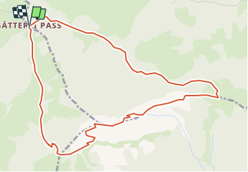
Randonnée Marche de 5,6 km à découvrir à Schwyz, Gersau, Gersau. Cette randonnée est proposée par Pfenniger.
Description
Vom Gätterlipass über Scharteggli,Chälenwald den Südwestgrat überqueren.Über die Südflanke zum Gipfel.
Über Ostgrat, Nordflenke ( sehr exponiert ),Spitz zur Egg absteigen.Über Bsetzibann,Rohrboden zurüch zum Gätterlipass.
Localisation
Pays :
Suisse
Région :
Schwyz
Département/Province :
Gersau
Commune :
Gersau
Localité :
Unknown
Départ:(Dec)
Départ:(UTM)
465895 ; 5207297 (32T) N.
Commentaires
Randonnées à proximité
![Randonnée A pied Arth - Rigi Kulm - Dächli - Photo](https://media.geolcdn.com/t/375/260/3c2cb0ab-5605-4529-8e72-77b21225ace2.jpeg&format=jpg&maxdim=2)
![A pied A pied](https://static1.geolcdn.com/sitytour/trail-icons/100.png)
![Randonnée A pied Arth - Hinder Dossen - Rigi Klösterli - Photo](https://media.geolcdn.com/t/375/260/3727fee8-a543-4af1-8e32-f04c5bf3c90a.jpeg&format=jpg&maxdim=2)
![A pied A pied](https://static1.geolcdn.com/sitytour/trail-icons/100.png)
Hinder Dossen - Rigi Klösterli
A pied
Facile
Arth,
Schwyz,
Schwyz,
Suisse
![](/images/other/stat-length.png)
4,1 km | 6,8 km-effort
1h 32min
![](https://static1.geolcdn.com/siteimages/upload/files/16400158638029165_repeat_loop_refresh_sync_direction_icon.png)
Non
![Randonnée A pied Arth - Goldau-Dächli - Photo](https://media.geolcdn.com/t/375/260/dev_a4792a56-aed8-4c53-a0a6-82e5ae078d7c.jpeg&format=jpg&maxdim=2)
![A pied A pied](https://static1.geolcdn.com/sitytour/trail-icons/100.png)
![Randonnée A pied Arth - Parkplatz A4 - Ochsenchneu - Photo](https://media.geolcdn.com/t/375/260/b696f0f2-2153-4a62-8662-61950384350f.jpeg&format=jpg&maxdim=2)
![A pied A pied](https://static1.geolcdn.com/sitytour/trail-icons/100.png)
Parkplatz A4 - Ochsenchneu
A pied
Facile
Arth,
Schwyz,
Schwyz,
Suisse
![](/images/other/stat-length.png)
3,1 km | 7 km-effort
1h 35min
![](https://static1.geolcdn.com/siteimages/upload/files/16400158638029165_repeat_loop_refresh_sync_direction_icon.png)
Non
![Randonnée V.T.T. Ingenbohl - Mythen - Photo](https://media.geolcdn.com/t/375/260/ext.jpg?maxdim=2&url=https%3A%2F%2Fstatic1.geolcdn.com%2Fsiteimages%2Fupload%2Ffiles%2F1524743154velo.jpg)
![V.T.T. V.T.T.](https://static1.geolcdn.com/sitytour/trail-icons/202.png)
![Randonnée V.T.T. Arth - Rigi - Photo](https://media.geolcdn.com/t/375/260/ext.jpg?maxdim=2&url=https%3A%2F%2Fstatic1.geolcdn.com%2Fsiteimages%2Fupload%2Ffiles%2F1524743154velo.jpg)
![V.T.T. V.T.T.](https://static1.geolcdn.com/sitytour/trail-icons/202.png)
![Randonnée Marche Ingenbohl - sf09_e5d - Photo](https://media.geolcdn.com/t/375/260/ext.jpg?maxdim=2&url=https%3A%2F%2Fstatic1.geolcdn.com%2Fsiteimages%2Fupload%2Ffiles%2F1553511878bg_sport_marche.png)
![Marche Marche](https://static1.geolcdn.com/sitytour/trail-icons/101.png)
![Randonnée Marche Gersau - sf09_e5c - Photo](https://media.geolcdn.com/t/375/260/ext.jpg?maxdim=2&url=https%3A%2F%2Fstatic1.geolcdn.com%2Fsiteimages%2Fupload%2Ffiles%2F1553511878bg_sport_marche.png)
![Marche Marche](https://static1.geolcdn.com/sitytour/trail-icons/101.png)
![Randonnée Marche Gersau - Rigi - Panorama - Photo](https://media.geolcdn.com/t/375/260/ext.jpg?maxdim=2&url=https%3A%2F%2Fstatic1.geolcdn.com%2Fsiteimages%2Fupload%2Ffiles%2F1553511878bg_sport_marche.png)
![Marche Marche](https://static1.geolcdn.com/sitytour/trail-icons/101.png)