![](/images/other/stat-length.png)
![Randonnée Marche Vollore-Montagne - Vollore_Pierre_Pamole - Photo](https://media.geolcdn.com/t/1900/400/6b691788-f28f-4215-bbc2-e488c61bc7e3.jpg&format=pjpeg&maxdim=2)
Vollore_Pierre_Pamole
jagarnier
Utilisateur GUIDE
![Longueur](/images/other/stat-length.png)
![Altitude max](https://static1.geolcdn.com/siteimages/upload/files/1508320355ic_sort_altitude_max_24dp.png)
![Dénivelé positif](https://static1.geolcdn.com/siteimages/upload/files/1508320355ic_sort_den_pos_24dp.png)
![Km-Effort](/images/other/stat-length.png)
![Altitude min](https://static1.geolcdn.com/siteimages/upload/files/1508320355ic_sort_altitude_min_24dp.png)
![Dénivelé négatif](https://static1.geolcdn.com/siteimages/upload/files/1508320355ic_sort_den_neg_24dp.png)
![Boucle](https://static1.geolcdn.com/siteimages/upload/files/16400158638029165_repeat_loop_refresh_sync_direction_icon.png)
![Marche](https://static1.geolcdn.com/sitytour/trail-icons/101.png)
5h00
Difficulté : Moyen
![Scannez ce code QR pour ouvrir la randonnée dans l'application SityTrail](https://capi.geolives.com/qq0zvz2zws4bq2lad0pu/sitytour/trails/2085790/qr.png?size=200)
Application GPS de randonnée GRATUITE
À propos
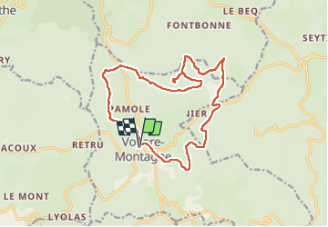
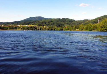
Randonnée Marche de 16,5 km à découvrir à Auvergne-Rhône-Alpes, Puy-de-Dôme, Vollore-Montagne. Cette randonnée est proposée par jagarnier.
Description
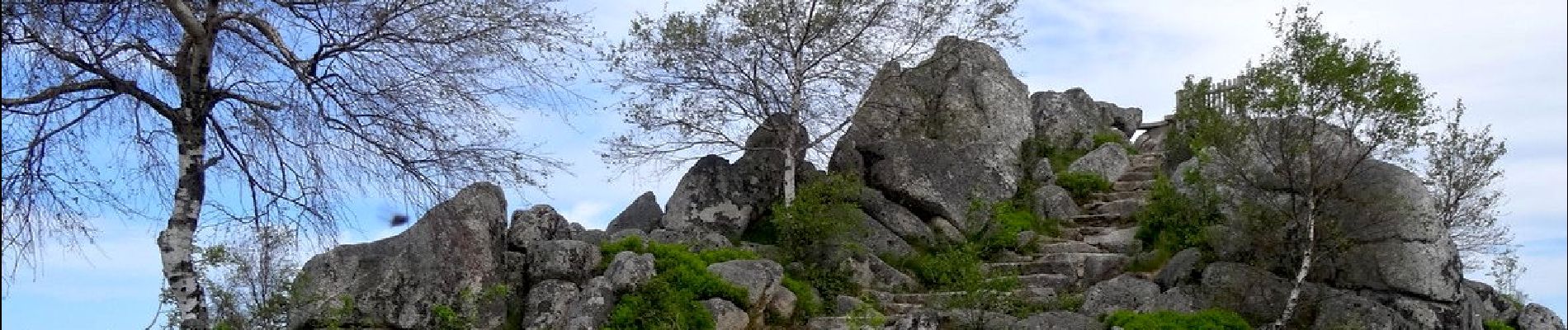
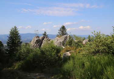
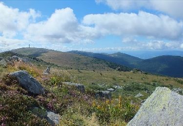
Le site de Pierre Pamole est situé à l'extrémité nord des Monts du Forez.
Son socle est constitué de roches magmatiques et métamorphiques. Le sommet est coiffé de plusieurs chaos granitiques.
L'édification de la chaîne s'est réalisée à l'ère primaire. Au tertiaire, le cycle alpin a créé le relief actuel avec des monts et des vallées.
Cet épisode s'est terminé par une phase volcanique, puis les glaciations du quaternaire ont érodé le paysage pour lui donner sa forme actuelle.
Localisation
Commentaires
Randonnées à proximité
![Randonnée A pied Vollore-Montagne - Pierre Pamole - Photo](https://media.geolcdn.com/t/375/260/9aafc2fe-4126-48bc-9178-9ec4b9f65852.jpeg&format=jpg&maxdim=2)
![A pied A pied](https://static1.geolcdn.com/sitytour/trail-icons/100.png)
A pied
![](/images/other/stat-length.png)
![](https://static1.geolcdn.com/siteimages/upload/files/16400158638029165_repeat_loop_refresh_sync_direction_icon.png)
![Randonnée Marche Vollore-Montagne - Pierre pamole - Photo](https://media.geolcdn.com/t/375/260/6ff9709e-f627-424b-aa61-bab39a073f9f.jpg&format=jpg&maxdim=2)
![Marche Marche](https://static1.geolcdn.com/sitytour/trail-icons/101.png)
Marche
![](/images/other/stat-length.png)
![](https://static1.geolcdn.com/siteimages/upload/files/16400158638029165_repeat_loop_refresh_sync_direction_icon.png)
![Randonnée A pied Vollore-Ville - Le Grun de Chignore - Photo](https://media.geolcdn.com/t/375/260/d670d619-94c1-4ebf-b98b-e05e4075dc52.jpeg&format=jpg&maxdim=2)
![A pied A pied](https://static1.geolcdn.com/sitytour/trail-icons/100.png)
A pied
![](/images/other/stat-length.png)
![](https://static1.geolcdn.com/siteimages/upload/files/16400158638029165_repeat_loop_refresh_sync_direction_icon.png)
![Randonnée Marche Viscomtat - La Virée des Rocs Nº2/Rocher de Pierre Beille - Photo](https://media.geolcdn.com/t/375/260/bf0a1021-65c7-48d0-bcc1-daa8d158a6cc.jpg&format=jpg&maxdim=2)
![Marche Marche](https://static1.geolcdn.com/sitytour/trail-icons/101.png)
Marche
![](/images/other/stat-length.png)
![](https://static1.geolcdn.com/siteimages/upload/files/16400158638029165_repeat_loop_refresh_sync_direction_icon.png)
![Randonnée Marche Sainte-Agathe - Ste_Agathe_Peage - Photo](https://media.geolcdn.com/t/375/260/ae73d591-dc6d-481d-b0b0-e0d1ded3bb7c.jpg&format=jpg&maxdim=2)
![Marche Marche](https://static1.geolcdn.com/sitytour/trail-icons/101.png)
Marche
![](/images/other/stat-length.png)
![](https://static1.geolcdn.com/siteimages/upload/files/16400158638029165_repeat_loop_refresh_sync_direction_icon.png)
![Randonnée Marche Vollore-Montagne - Vollore_Lit_Vierge - Photo](https://media.geolcdn.com/t/375/260/feed7f70-4650-407e-b53c-6730463e49f9.jpg&format=jpg&maxdim=2)
![Marche Marche](https://static1.geolcdn.com/sitytour/trail-icons/101.png)
Marche
![](/images/other/stat-length.png)
![](https://static1.geolcdn.com/siteimages/upload/files/16400158638029165_repeat_loop_refresh_sync_direction_icon.png)
![Randonnée Marche Sainte-Agathe - Saint agate 3ieme jour - Photo](https://media.geolcdn.com/t/375/260/339ddc93-a3ab-4bd3-b422-9ab8f5ca89f2.jpg&format=jpg&maxdim=2)
![Marche Marche](https://static1.geolcdn.com/sitytour/trail-icons/101.png)
Marche
![](/images/other/stat-length.png)
![](https://static1.geolcdn.com/siteimages/upload/files/16400158638029165_repeat_loop_refresh_sync_direction_icon.png)
![Randonnée A pied Vollore-Montagne - Le Lit de la Vierge - Photo](https://media.geolcdn.com/t/375/260/ext.jpg?maxdim=2&url=https%3A%2F%2Fstatic1.geolcdn.com%2Fsiteimages%2Fupload%2Ffiles%2F1545311037marcheuse_200dpi.jpg)
![A pied A pied](https://static1.geolcdn.com/sitytour/trail-icons/100.png)
A pied
![](/images/other/stat-length.png)
![](https://static1.geolcdn.com/siteimages/upload/files/16400158638029165_repeat_loop_refresh_sync_direction_icon.png)
![Randonnée Marche Aubusson-d'Auvergne - Aubusson_Fontcuberte - Photo](https://media.geolcdn.com/t/375/260/df5382ed-2df1-4cff-b5f2-9989e189d040.png&format=jpg&maxdim=2)
![Marche Marche](https://static1.geolcdn.com/sitytour/trail-icons/101.png)
Marche
![](/images/other/stat-length.png)
![](https://static1.geolcdn.com/siteimages/upload/files/16400158638029165_repeat_loop_refresh_sync_direction_icon.png)