![](/images/other/stat-length.png)
![Randonnée Ski de randonnée Tignes - col de la sache et Col de la sachette - Photo](https://media.geolcdn.com/t/1900/400/e54ff6cf-7872-4781-879e-c465d2ef4990.jpg&format=pjpeg&maxdim=2)
col de la sache et Col de la sachette
nadd73
Utilisateur GUIDE
![Longueur](/images/other/stat-length.png)
Longueur
17,9 km
![Altitude max](https://static1.geolcdn.com/siteimages/upload/files/1508320355ic_sort_altitude_max_24dp.png)
Altitude max
2766 m
![Dénivelé positif](https://static1.geolcdn.com/siteimages/upload/files/1508320355ic_sort_den_pos_24dp.png)
Dénivelé positif
1430 m
![Km-Effort](/images/other/stat-length.png)
Km-Effort
36 km
![Altitude min](https://static1.geolcdn.com/siteimages/upload/files/1508320355ic_sort_altitude_min_24dp.png)
Altitude min
1822 m
![Dénivelé négatif](https://static1.geolcdn.com/siteimages/upload/files/1508320355ic_sort_den_neg_24dp.png)
Dénivelé négatif
1257 m
![Boucle](https://static1.geolcdn.com/siteimages/upload/files/16400158638029165_repeat_loop_refresh_sync_direction_icon.png)
Boucle
Non
Date de création :
2019-05-14 05:31:57.033
Dernière modification :
2019-05-14 14:24:12.362
![Ski de randonnée](https://static1.geolcdn.com/sitytour/trail-icons/503.png)
7h30
Difficulté : Moyen
![Scannez ce code QR pour ouvrir la randonnée dans l'application SityTrail](https://capi.geolives.com/qq0zvz2zws4bq2lad0pu/sitytour/trails/2083180/qr.png?size=200)
Application GPS de randonnée GRATUITE
À propos
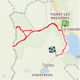
Randonnée Ski de randonnée de 17,9 km à découvrir à Auvergne-Rhône-Alpes, Savoie, Tignes. Cette randonnée est proposée par nadd73.
Description
départ de Tignes,
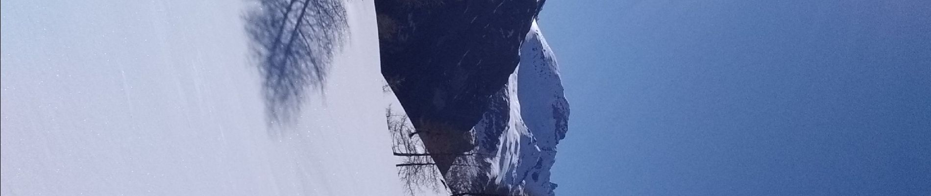
Nous devions faire un circuit mais au Col de la Sache trop de corniches.
donc nous descendons comme la montée.
Nous montons au Col de la Sachette
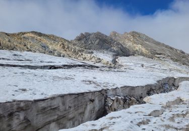
pour la descente jusqu'à la voiture nous avons fait suivant la neige.
Localisation
Pays :
France
Région :
Auvergne-Rhône-Alpes
Département/Province :
Savoie
Commune :
Tignes
Localité :
Unknown
Départ:(Dec)
Départ:(UTM)
337634 ; 5040200 (32T) N.
Commentaires
Randonnées à proximité
![Randonnée Marche Tignes - la pointe de Picheru - Photo](https://media.geolcdn.com/t/375/260/ext.jpg?maxdim=2&url=https%3A%2F%2Fservices.sitytrail.com%2FGeolivesWS%2FDownloadMedia.ashx%3FTrailID%3D813856%26Media%3Dfix__20170820100255.jpg)
![Marche Marche](https://static1.geolcdn.com/sitytour/trail-icons/101.png)
la pointe de Picheru
Marche
Moyen
(1)
Tignes,
Auvergne-Rhône-Alpes,
Savoie,
France
![](/images/other/stat-length.png)
13,8 km | 23 km-effort
5h 36min
![](https://static1.geolcdn.com/siteimages/upload/files/16400158638029165_repeat_loop_refresh_sync_direction_icon.png)
Oui
![Randonnée Marche Tignes - l'aiguille perçée - Photo](https://media.geolcdn.com/t/375/260/ext.jpg?maxdim=2&url=https%3A%2F%2Fservices.sitytrail.com%2FGeolivesWS%2FDownloadMedia.ashx%3FTrailID%3D337133%26Media%3Dfix__20140820112508.jpg)
![Marche Marche](https://static1.geolcdn.com/sitytour/trail-icons/101.png)
l'aiguille perçée
Marche
Facile
(1)
Tignes,
Auvergne-Rhône-Alpes,
Savoie,
France
![](/images/other/stat-length.png)
5,8 km | 9,8 km-effort
3h 27min
![](https://static1.geolcdn.com/siteimages/upload/files/16400158638029165_repeat_loop_refresh_sync_direction_icon.png)
Non
![Randonnée Marche Tignes - lacs du saut et de la sassiere - Photo](https://media.geolcdn.com/t/375/260/ext.jpg?maxdim=2&url=https%3A%2F%2Fservices.sitytrail.com%2FGeolivesWS%2FDownloadMedia.ashx%3FTrailID%3D336967%26Media%3D637041f5-cff1-4406-a972-10b75ef104dd.JPG)
![Marche Marche](https://static1.geolcdn.com/sitytour/trail-icons/101.png)
lacs du saut et de la sassiere
Marche
Très facile
(3)
Tignes,
Auvergne-Rhône-Alpes,
Savoie,
France
![](/images/other/stat-length.png)
9 km | 12,6 km-effort
3h 56min
![](https://static1.geolcdn.com/siteimages/upload/files/16400158638029165_repeat_loop_refresh_sync_direction_icon.png)
Oui
![Randonnée Marche Tignes - Tignes 1800 lac de la Sassièrre aller-retour - Photo](https://media.geolcdn.com/t/375/260/ae37ca96-9517-4fd4-82f6-2f8c10f3622c.jpg&format=jpg&maxdim=2)
![Marche Marche](https://static1.geolcdn.com/sitytour/trail-icons/101.png)
Tignes 1800 lac de la Sassièrre aller-retour
Marche
Moyen
(1)
Tignes,
Auvergne-Rhône-Alpes,
Savoie,
France
![](/images/other/stat-length.png)
28 km | 47 km-effort
1h 0min
![](https://static1.geolcdn.com/siteimages/upload/files/16400158638029165_repeat_loop_refresh_sync_direction_icon.png)
Oui
![Randonnée Autre activité Tignes - Refuge du Palet Col de la Tourne - Photo](https://media.geolcdn.com/t/375/260/ext.jpg?maxdim=2&url=https%3A%2F%2Fservices.sitytrail.com%2FGeolivesWS%2FDownloadMedia.ashx%3FTrailID%3D627243%26Media%3Deac5cf48-a447-4e5f-a31a-610b7e2f4089.jpg)
![Autre activité Autre activité](https://static1.geolcdn.com/sitytour/trail-icons/900.png)
Refuge du Palet Col de la Tourne
Autre activité
Moyen
(1)
Tignes,
Auvergne-Rhône-Alpes,
Savoie,
France
![](/images/other/stat-length.png)
11,9 km | 22 km-effort
3h 35min
![](https://static1.geolcdn.com/siteimages/upload/files/16400158638029165_repeat_loop_refresh_sync_direction_icon.png)
Non
![Randonnée Marche Tignes - boucle Tignes le lac - la daille - Photo](https://media.geolcdn.com/t/375/260/ext.jpg?maxdim=2&url=https%3A%2F%2Fservices.sitytrail.com%2FGeolivesWS%2FDownloadMedia.ashx%3FTrailID%3D132978%26Media%3D20120609144529.jpg)
![Marche Marche](https://static1.geolcdn.com/sitytour/trail-icons/101.png)
boucle Tignes le lac - la daille
Marche
Facile
(1)
Tignes,
Auvergne-Rhône-Alpes,
Savoie,
France
![](/images/other/stat-length.png)
14 km | 23 km-effort
2h 56min
![](https://static1.geolcdn.com/siteimages/upload/files/16400158638029165_repeat_loop_refresh_sync_direction_icon.png)
Oui
![Randonnée Marche Val-d'Isère - Les cascades des salins au départ de val d’Isère - Photo](https://media.geolcdn.com/t/375/260/c3b76218-f72c-4eeb-8155-41f32eab8f13.jpg&format=jpg&maxdim=2)
![Marche Marche](https://static1.geolcdn.com/sitytour/trail-icons/101.png)
Les cascades des salins au départ de val d’Isère
Marche
Moyen
(1)
Val-d'Isère,
Auvergne-Rhône-Alpes,
Savoie,
France
![](/images/other/stat-length.png)
9,5 km | 15,2 km-effort
3h 40min
![](https://static1.geolcdn.com/siteimages/upload/files/16400158638029165_repeat_loop_refresh_sync_direction_icon.png)
Oui
![Randonnée Marche Tignes - Refuge de la Martin - Photo](https://media.geolcdn.com/t/375/260/ext.jpg?maxdim=2&url=https%3A%2F%2Fservices.sitytrail.com%2FGeolivesWS%2FDownloadMedia.ashx%3FTrailID%3D853550%26Media%3Dfix__20171025152818.jpg)
![Marche Marche](https://static1.geolcdn.com/sitytour/trail-icons/101.png)
Refuge de la Martin
Marche
Moyen
(1)
Tignes,
Auvergne-Rhône-Alpes,
Savoie,
France
![](/images/other/stat-length.png)
13,3 km | 26 km-effort
6h 4min
![](https://static1.geolcdn.com/siteimages/upload/files/16400158638029165_repeat_loop_refresh_sync_direction_icon.png)
Oui
![Randonnée Marche Tignes - approche glacière de la cime de la Golette - Photo](https://media.geolcdn.com/t/375/260/72e50cb0-5647-449b-b1a2-a84fe5e68f8a.jpg&format=jpg&maxdim=2)
![Marche Marche](https://static1.geolcdn.com/sitytour/trail-icons/101.png)
approche glacière de la cime de la Golette
Marche
Très difficile
Tignes,
Auvergne-Rhône-Alpes,
Savoie,
France
![](/images/other/stat-length.png)
18,5 km | 32 km-effort
8h 29min
![](https://static1.geolcdn.com/siteimages/upload/files/16400158638029165_repeat_loop_refresh_sync_direction_icon.png)
Oui