![](/images/other/stat-length.png)
![Randonnée Marche Kordel - Ramstein burg 16,5km - Photo](https://media.geolcdn.com/t/1900/400/7d21dad1-c3b2-4db7-ac7d-a741c4dcae1c.jpg&format=pjpeg&maxdim=2)
Ramstein burg 16,5km
rvapeldo
Utilisateur GUIDE
![Longueur](/images/other/stat-length.png)
![Boucle](https://static1.geolcdn.com/siteimages/upload/files/16400158638029165_repeat_loop_refresh_sync_direction_icon.png)
![Marche](https://static1.geolcdn.com/sitytour/trail-icons/101.png)
5h24
Difficulté : Moyen
![Scannez ce code QR pour ouvrir la randonnée dans l'application SityTrail](https://capi.geolives.com/qq0zvz2zws4bq2lad0pu/sitytour/trails/2078056/qr.png?size=200)
Application GPS de randonnée GRATUITE
À propos
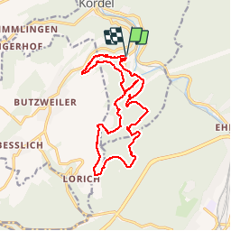
Randonnée Marche de 16,9 km à découvrir à Rhénanie-Palatinat, Landkreis Trier-Saarburg, Kordel. Cette randonnée est proposée par rvapeldo.
Description
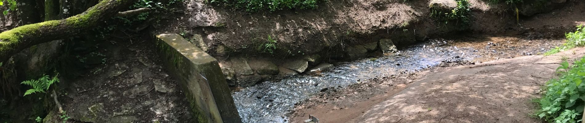
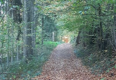
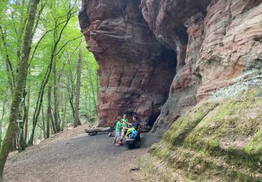
Beau tour qui emprunte une bonne partie du sentier romain (römerpfad) et de l’eifelsteig. Avec des séquences très différentes. Il démarre par la remontée d’une petite rivière sauvage, que l’on suit par des ponts et des sentiers bien équipés. La boucle passe par des grottes de grès rouge, dont la Genovevahöle, une sorte de mine romaine (?), une partie dégagée où l’horizon s’ouvre vers Trèves. Elle termine par le château de Ramstein, une magnifique ruine rouge dans les couleurs des pierres du coin. Ambiance très petite Suisse (Mulerthal), qui n’est pas bien loin.
Localisation
Commentaires
Randonnées à proximité
![Randonnée Marche Newel - RÖMERPFAD - Photo](https://media.geolcdn.com/t/375/260/644331ac-d13d-4288-9471-a5049a50e5a6.jpg&format=jpg&maxdim=2)
![Marche Marche](https://static1.geolcdn.com/sitytour/trail-icons/101.png)
Marche
![](/images/other/stat-length.png)
![](https://static1.geolcdn.com/siteimages/upload/files/16400158638029165_repeat_loop_refresh_sync_direction_icon.png)
![Randonnée Marche Kordel - Kordel ramstein burg 23 km - Photo](https://media.geolcdn.com/t/375/260/2119a336-ea43-46df-b592-b7c9791928fd.jpg&format=jpg&maxdim=2)
![Marche Marche](https://static1.geolcdn.com/sitytour/trail-icons/101.png)
Marche
![](/images/other/stat-length.png)
![](https://static1.geolcdn.com/siteimages/upload/files/16400158638029165_repeat_loop_refresh_sync_direction_icon.png)
![Randonnée Marche Kordel - ESt-15 - Photo](https://media.geolcdn.com/t/375/260/ext.jpg?maxdim=2&url=https%3A%2F%2Fstatic1.geolcdn.com%2Fsiteimages%2Fupload%2Ffiles%2F1553511878bg_sport_marche.png)
![Marche Marche](https://static1.geolcdn.com/sitytour/trail-icons/101.png)
Marche
![](/images/other/stat-length.png)
![](https://static1.geolcdn.com/siteimages/upload/files/16400158638029165_repeat_loop_refresh_sync_direction_icon.png)
![Randonnée Marche Newel - Romerpfad - Photo](https://media.geolcdn.com/t/375/260/ext.jpg?maxdim=2&url=https%3A%2F%2Fstatic1.geolcdn.com%2Fsiteimages%2Fupload%2Ffiles%2F1553511878bg_sport_marche.png)
![Marche Marche](https://static1.geolcdn.com/sitytour/trail-icons/101.png)
Marche
![](/images/other/stat-length.png)
![](https://static1.geolcdn.com/siteimages/upload/files/16400158638029165_repeat_loop_refresh_sync_direction_icon.png)
![Randonnée Autre activité Kordel - Duitsland - Eifelsteig 12: Kordel - Trier - Photo](https://media.geolcdn.com/t/375/260/ext.jpg?maxdim=2&url=https%3A%2F%2Fstatic1.geolcdn.com%2Fsiteimages%2Fupload%2Ffiles%2F1545311037marcheuse_200dpi.jpg)
![Autre activité Autre activité](https://static1.geolcdn.com/sitytour/trail-icons/900.png)
Autre activité
![](/images/other/stat-length.png)
![](https://static1.geolcdn.com/siteimages/upload/files/16400158638029165_repeat_loop_refresh_sync_direction_icon.png)