![](/images/other/stat-length.png)
![Randonnée Marche Saint-Paul-de-Fenouillet - 66_Saint Paul de Fenouillet_Aigues Bonnes_J3 - Photo](https://media.geolcdn.com/t/1900/400/ext.pjpeg?maxdim=2&url=https%3A%2F%2Fstatic1.geolcdn.com%2Fsiteimages%2Fupload%2Ffiles%2F1553511878bg_sport_marche.png)
66_Saint Paul de Fenouillet_Aigues Bonnes_J3
jab31
Utilisateur
![Longueur](/images/other/stat-length.png)
Longueur
24 km
![Altitude max](https://static1.geolcdn.com/siteimages/upload/files/1508320355ic_sort_altitude_max_24dp.png)
Altitude max
676 m
![Dénivelé positif](https://static1.geolcdn.com/siteimages/upload/files/1508320355ic_sort_den_pos_24dp.png)
Dénivelé positif
825 m
![Km-Effort](/images/other/stat-length.png)
Km-Effort
34 km
![Altitude min](https://static1.geolcdn.com/siteimages/upload/files/1508320355ic_sort_altitude_min_24dp.png)
Altitude min
250 m
![Dénivelé négatif](https://static1.geolcdn.com/siteimages/upload/files/1508320355ic_sort_den_neg_24dp.png)
Dénivelé négatif
449 m
![Boucle](https://static1.geolcdn.com/siteimages/upload/files/16400158638029165_repeat_loop_refresh_sync_direction_icon.png)
Boucle
Non
Date de création :
2019-05-09 06:53:53.266
Dernière modification :
2020-02-10 08:57:30.738
![Marche](https://static1.geolcdn.com/sitytour/trail-icons/101.png)
6h56
Difficulté : Moyen
![Scannez ce code QR pour ouvrir la randonnée dans l'application SityTrail](https://capi.geolives.com/qq0zvz2zws4bq2lad0pu/sitytour/trails/2077251/qr.png?size=200)
Application GPS de randonnée GRATUITE
À propos
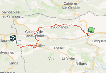
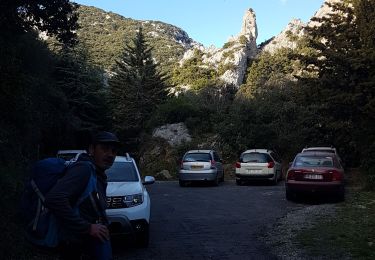
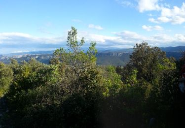
Randonnée Marche de 24 km à découvrir à Occitanie, Pyrénées-Orientales, Saint-Paul-de-Fenouillet. Cette randonnée est proposée par jab31.
Description
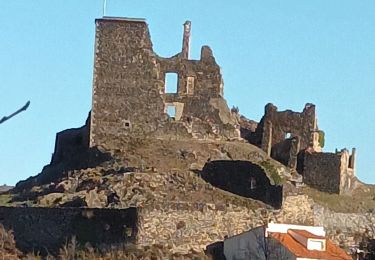
Château de Saint Pierre à Fenouillet
Gorges de Saint Jaume
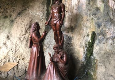
Points d'eau à Caudiès et à Saint Pierre de Fenouillet
Localisation
Pays :
France
Région :
Occitanie
Département/Province :
Pyrénées-Orientales
Commune :
Saint-Paul-de-Fenouillet
Localité :
Unknown
Départ:(Dec)
Départ:(UTM)
458919 ; 4739708 (31T) N.
Commentaires
Randonnées à proximité
![Randonnée Marche Saint-Paul-de-Fenouillet - Ermitage de Galamus - Photo](https://media.geolcdn.com/t/375/260/46039162-6164-4640-a304-ccd455d5027d.jpg&format=jpg&maxdim=2)
![Marche Marche](https://static1.geolcdn.com/sitytour/trail-icons/101.png)
Ermitage de Galamus
Marche
Facile
Saint-Paul-de-Fenouillet,
Occitanie,
Pyrénées-Orientales,
France
![](/images/other/stat-length.png)
1,3 km | 2,3 km-effort
26min
![](https://static1.geolcdn.com/siteimages/upload/files/16400158638029165_repeat_loop_refresh_sync_direction_icon.png)
Oui
![Randonnée Marche Saint-Paul-de-Fenouillet - La Quille - Photo](https://media.geolcdn.com/t/375/260/47f7336c-3219-4083-bfb3-c8b198d14d48.jpg&format=jpg&maxdim=2)
![Marche Marche](https://static1.geolcdn.com/sitytour/trail-icons/101.png)
La Quille
Marche
Très difficile
Saint-Paul-de-Fenouillet,
Occitanie,
Pyrénées-Orientales,
France
![](/images/other/stat-length.png)
16,9 km | 29 km-effort
6h 23min
![](https://static1.geolcdn.com/siteimages/upload/files/16400158638029165_repeat_loop_refresh_sync_direction_icon.png)
Non
![Randonnée Marche Saint-Paul-de-Fenouillet - Autour des gorges de Galamus - Photo](https://media.geolcdn.com/t/375/260/ebb1bc80-1a1f-4b07-90dd-5976415c2a9f.jpg&format=jpg&maxdim=2)
![Marche Marche](https://static1.geolcdn.com/sitytour/trail-icons/101.png)
Autour des gorges de Galamus
Marche
Très difficile
Saint-Paul-de-Fenouillet,
Occitanie,
Pyrénées-Orientales,
France
![](/images/other/stat-length.png)
12,4 km | 22 km-effort
6h 28min
![](https://static1.geolcdn.com/siteimages/upload/files/16400158638029165_repeat_loop_refresh_sync_direction_icon.png)
Oui
![Randonnée Marche Le Vivier - Le Vivier. Hêtre remarquable de 500 ans - Photo](https://media.geolcdn.com/t/375/260/32faf676-c96e-4eae-b2ba-ff00db62d055.jpg&format=jpg&maxdim=2)
![Marche Marche](https://static1.geolcdn.com/sitytour/trail-icons/101.png)
Le Vivier. Hêtre remarquable de 500 ans
Marche
Moyen
Le Vivier,
Occitanie,
Pyrénées-Orientales,
France
![](/images/other/stat-length.png)
13,1 km | 21 km-effort
3h 41min
![](https://static1.geolcdn.com/siteimages/upload/files/16400158638029165_repeat_loop_refresh_sync_direction_icon.png)
Oui
![Randonnée Marche Saint-Paul-de-Fenouillet - st Paul de fenouinlet / col lenty et retour - Photo](https://media.geolcdn.com/t/375/260/281156ab-3036-4fe8-93da-4a2eaadc40df.jpg&format=jpg&maxdim=2)
![Marche Marche](https://static1.geolcdn.com/sitytour/trail-icons/101.png)
st Paul de fenouinlet / col lenty et retour
Marche
Difficile
Saint-Paul-de-Fenouillet,
Occitanie,
Pyrénées-Orientales,
France
![](/images/other/stat-length.png)
9,6 km | 15,6 km-effort
2h 59min
![](https://static1.geolcdn.com/siteimages/upload/files/16400158638029165_repeat_loop_refresh_sync_direction_icon.png)
Oui
![Randonnée Marche Saint-Paul-de-Fenouillet - Gorges galamus-Nissol_T - Photo](https://media.geolcdn.com/t/375/260/ext.jpg?maxdim=2&url=https%3A%2F%2Fservices.sitytrail.com%2FGeolivesWS%2FDownloadMedia.ashx%3FTrailID%3D306372%26Media%3Da7076bb5-3bf2-4c5a-a4d8-4346c03497ec.jpg)
![Marche Marche](https://static1.geolcdn.com/sitytour/trail-icons/101.png)
Gorges galamus-Nissol_T
Marche
Moyen
Saint-Paul-de-Fenouillet,
Occitanie,
Pyrénées-Orientales,
France
![](/images/other/stat-length.png)
13,8 km | 22 km-effort
4h 40min
![](https://static1.geolcdn.com/siteimages/upload/files/16400158638029165_repeat_loop_refresh_sync_direction_icon.png)
Oui
![Randonnée Marche Saint-Paul-de-Fenouillet - Gorges galamus - Photo](https://media.geolcdn.com/t/375/260/bcffc5c8-a228-45e3-afaa-dce84f23c131.jpg&format=jpg&maxdim=2)
![Marche Marche](https://static1.geolcdn.com/sitytour/trail-icons/101.png)
Gorges galamus
Marche
Saint-Paul-de-Fenouillet,
Occitanie,
Pyrénées-Orientales,
France
![](/images/other/stat-length.png)
40 km | 84 km-effort
2h 54min
![](https://static1.geolcdn.com/siteimages/upload/files/16400158638029165_repeat_loop_refresh_sync_direction_icon.png)
Non
![Randonnée Marche Saint-Paul-de-Fenouillet - Le pech d Auroux par le pla de Brézou - Photo](https://media.geolcdn.com/t/375/260/65031889-e50e-4c1b-afbc-519ffd309eb3.jpg&format=jpg&maxdim=2)
![Marche Marche](https://static1.geolcdn.com/sitytour/trail-icons/101.png)
Le pech d Auroux par le pla de Brézou
Marche
Difficile
(1)
Saint-Paul-de-Fenouillet,
Occitanie,
Pyrénées-Orientales,
France
![](/images/other/stat-length.png)
10 km | 18,6 km-effort
4h 38min
![](https://static1.geolcdn.com/siteimages/upload/files/16400158638029165_repeat_loop_refresh_sync_direction_icon.png)
Oui
![Randonnée Marche Le Vivier - LEVIVIER - Photo](https://media.geolcdn.com/t/375/260/5457f460-6e65-4ae1-9836-00f0047e1397.jpg&format=jpg&maxdim=2)
![Marche Marche](https://static1.geolcdn.com/sitytour/trail-icons/101.png)
LEVIVIER
Marche
Très difficile
Le Vivier,
Occitanie,
Pyrénées-Orientales,
France
![](/images/other/stat-length.png)
14,1 km | 23 km-effort
4h 16min
![](https://static1.geolcdn.com/siteimages/upload/files/16400158638029165_repeat_loop_refresh_sync_direction_icon.png)
Oui