![](/images/other/stat-length.png)
![Randonnée Marche Namur - WIERDE ... par l'ancien Fort d'Andoy et le Mont Sainte-Marie. - Photo](https://media.geolcdn.com/t/1900/400/5b79ea22-7db5-4b45-8c9e-d0867d0adc8a.jpg&format=pjpeg&maxdim=2)
WIERDE ... par l'ancien Fort d'Andoy et le Mont Sainte-Marie.
GerardBouche
Utilisateur
![Longueur](/images/other/stat-length.png)
Longueur
9,9 km
![Altitude max](https://static1.geolcdn.com/siteimages/upload/files/1508320355ic_sort_altitude_max_24dp.png)
Altitude max
219 m
![Dénivelé positif](https://static1.geolcdn.com/siteimages/upload/files/1508320355ic_sort_den_pos_24dp.png)
Dénivelé positif
174 m
![Km-Effort](/images/other/stat-length.png)
Km-Effort
12,3 km
![Altitude min](https://static1.geolcdn.com/siteimages/upload/files/1508320355ic_sort_altitude_min_24dp.png)
Altitude min
138 m
![Dénivelé négatif](https://static1.geolcdn.com/siteimages/upload/files/1508320355ic_sort_den_neg_24dp.png)
Dénivelé négatif
174 m
![Boucle](https://static1.geolcdn.com/siteimages/upload/files/16400158638029165_repeat_loop_refresh_sync_direction_icon.png)
Boucle
Oui
Date de création :
2019-05-09 11:27:27.203
Dernière modification :
2019-05-11 06:14:05.057
![Marche](https://static1.geolcdn.com/sitytour/trail-icons/101.png)
2h20
Difficulté : Très facile
![Scannez ce code QR pour ouvrir la randonnée dans l'application SityTrail](https://capi.geolives.com/qq0zvz2zws4bq2lad0pu/sitytour/trails/2076955/qr.png?size=200)
Application GPS de randonnée GRATUITE
À propos
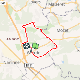
Randonnée Marche de 9,9 km à découvrir à Wallonie, Namur, Namur. Cette randonnée est proposée par GerardBouche.
Description
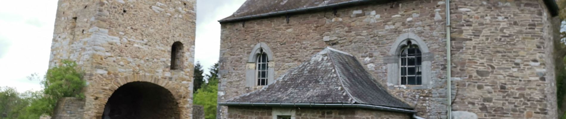
Depuis l'église de Wierde, un très beau parcours par le "Bois de Jeumont" en contournant l'ancien "Fort d'Andoy" avant de rejoindre le hameau de Limoy. Continuer par la Ferme de Basseille avant de retrouver le Mont Sainte-Marie.
Localisation
Pays :
Belgique
Région :
Wallonie
Département/Province :
Namur
Commune :
Namur
Localité :
Wierde
Départ:(Dec)
Départ:(UTM)
638517 ; 5587761 (31U) N.
Commentaires
Randonnées à proximité
![Randonnée Marche Gesves - RB-Na-01_Faulx-les-Tombes_via-racc - Photo](https://media.geolcdn.com/t/375/260/ext.jpg?maxdim=2&url=https%3A%2F%2Fservices.sitytrail.com%2FGeolivesWS%2FDownloadMedia.ashx%3FTrailID%3D213609%26Media%3D506f23b2-0581-4f03-b006-9ca575596278.jpg)
![Marche Marche](https://static1.geolcdn.com/sitytour/trail-icons/101.png)
RB-Na-01_Faulx-les-Tombes_via-racc
Marche
Très difficile
(15)
Gesves,
Wallonie,
Namur,
Belgique
![](/images/other/stat-length.png)
18,3 km | 25 km-effort
5h 34min
![](https://static1.geolcdn.com/siteimages/upload/files/16400158638029165_repeat_loop_refresh_sync_direction_icon.png)
Oui
![Randonnée Marche Gesves - RB-Na-01_Faulx-les-Tombes - Photo](https://media.geolcdn.com/t/375/260/ext.jpg?maxdim=2&url=https%3A%2F%2Fservices.sitytrail.com%2FGeolivesWS%2FDownloadMedia.ashx%3FTrailID%3D179626%26Media%3D506f23b2-0581-4f03-b006-9ca575596278.jpg)
![Marche Marche](https://static1.geolcdn.com/sitytour/trail-icons/101.png)
RB-Na-01_Faulx-les-Tombes
Marche
Très difficile
(15)
Gesves,
Wallonie,
Namur,
Belgique
![](/images/other/stat-length.png)
25 km | 33 km-effort
7h 26min
![](https://static1.geolcdn.com/siteimages/upload/files/16400158638029165_repeat_loop_refresh_sync_direction_icon.png)
Oui
![Randonnée Marche Gesves - GESVES -Mozet- N°06- Biodiversité - Photo](https://media.geolcdn.com/t/375/260/ext.jpg?maxdim=2&url=https%3A%2F%2Fservices.sitytrail.com%2FGeolivesWS%2FDownloadMedia.ashx%3FTrailID%3D121400%26Media%3D865b88e1-90ed-4454-a365-7e82ed8502df.JPG)
![Marche Marche](https://static1.geolcdn.com/sitytour/trail-icons/101.png)
GESVES -Mozet- N°06- Biodiversité
Marche
Facile
(10)
Gesves,
Wallonie,
Namur,
Belgique
![](/images/other/stat-length.png)
6,3 km | 7,8 km-effort
1h 41min
![](https://static1.geolcdn.com/siteimages/upload/files/16400158638029165_repeat_loop_refresh_sync_direction_icon.png)
Oui
![Randonnée Marche Andenne - La Vadrouille des Castors - Photo](https://media.geolcdn.com/t/375/260/ext.jpg?maxdim=2&url=https%3A%2F%2Fservices.sitytrail.com%2FGeolivesWS%2FDownloadMedia.ashx%3FTrailID%3D272035%26Media%3D1f2a432f-27e3-4b07-a115-5648fc3f71b1.jpg)
![Marche Marche](https://static1.geolcdn.com/sitytour/trail-icons/101.png)
La Vadrouille des Castors
Marche
Facile
(5)
Andenne,
Wallonie,
Namur,
Belgique
![](/images/other/stat-length.png)
3,6 km | 4,8 km-effort
1h 0min
![](https://static1.geolcdn.com/siteimages/upload/files/16400158638029165_repeat_loop_refresh_sync_direction_icon.png)
Oui
![Randonnée Marche Gesves - RF-Na-03-Goyet_Grande-boucle - Photo](https://media.geolcdn.com/t/375/260/ext.jpg?maxdim=2&url=https%3A%2F%2Fservices.sitytrail.com%2FGeolivesWS%2FDownloadMedia.ashx%3FTrailID%3D545745%26Media%3D72077e8d-e20a-4ee7-98f3-ad34263963e3.JPG)
![Marche Marche](https://static1.geolcdn.com/sitytour/trail-icons/101.png)
RF-Na-03-Goyet_Grande-boucle
Marche
Moyen
(5)
Gesves,
Wallonie,
Namur,
Belgique
![](/images/other/stat-length.png)
6,4 km | 8,9 km-effort
1h 54min
![](https://static1.geolcdn.com/siteimages/upload/files/16400158638029165_repeat_loop_refresh_sync_direction_icon.png)
Oui
![Randonnée Marche Namur - De Naninne vers Dave par les Fonds de Lustin et les Bois d'Acremont - Photo](https://media.geolcdn.com/t/375/260/ext.jpg?maxdim=2&url=https%3A%2F%2Fstatic1.geolcdn.com%2Fsiteimages%2Fupload%2Ffiles%2F1553511878bg_sport_marche.png)
![Marche Marche](https://static1.geolcdn.com/sitytour/trail-icons/101.png)
De Naninne vers Dave par les Fonds de Lustin et les Bois d'Acremont
Marche
Moyen
(5)
Namur,
Wallonie,
Namur,
Belgique
![](/images/other/stat-length.png)
19 km | 25 km-effort
5h 0min
![](https://static1.geolcdn.com/siteimages/upload/files/16400158638029165_repeat_loop_refresh_sync_direction_icon.png)
Oui
![Randonnée Marche Assesse - RL-GG-18_Sart-Bernard_Andenne - Photo](https://media.geolcdn.com/t/375/260/ee170bcd-2fb4-4927-aeb6-2a32aed3e834.jpg&format=jpg&maxdim=2)
![Marche Marche](https://static1.geolcdn.com/sitytour/trail-icons/101.png)
RL-GG-18_Sart-Bernard_Andenne
Marche
Très difficile
(2)
Assesse,
Wallonie,
Namur,
Belgique
![](/images/other/stat-length.png)
25 km | 32 km-effort
6h 49min
![](https://static1.geolcdn.com/siteimages/upload/files/16400158638029165_repeat_loop_refresh_sync_direction_icon.png)
Non
![Randonnée Marche Andenne - Promenade Thon-Samson - Photo](https://media.geolcdn.com/t/375/260/ext.jpg?maxdim=2&url=https%3A%2F%2Fservices.sitytrail.com%2FGeolivesWS%2FDownloadMedia.ashx%3FTrailID%3D272050%26Media%3Db6cbff1f-3300-45a6-b7c3-0805dc308e5c.jpg)
![Marche Marche](https://static1.geolcdn.com/sitytour/trail-icons/101.png)
Promenade Thon-Samson
Marche
Facile
(2)
Andenne,
Wallonie,
Namur,
Belgique
![](/images/other/stat-length.png)
6,5 km | 8,2 km-effort
1h 30min
![](https://static1.geolcdn.com/siteimages/upload/files/16400158638029165_repeat_loop_refresh_sync_direction_icon.png)
Oui
![Randonnée Marche Andenne - Le Parcours du Trou Perdu - Photo](https://media.geolcdn.com/t/375/260/ext.jpg?maxdim=2&url=https%3A%2F%2Fservices.sitytrail.com%2FGeolivesWS%2FDownloadMedia.ashx%3FTrailID%3D272038%26Media%3D97a7fb2e-bb41-43bb-80fd-185ec0b16fed.jpg)
![Marche Marche](https://static1.geolcdn.com/sitytour/trail-icons/101.png)
Le Parcours du Trou Perdu
Marche
Moyen
(3)
Andenne,
Wallonie,
Namur,
Belgique
![](/images/other/stat-length.png)
7,3 km | 9 km-effort
2h 5min
![](https://static1.geolcdn.com/siteimages/upload/files/16400158638029165_repeat_loop_refresh_sync_direction_icon.png)
Oui
bruit de la circulation trop présent. tracé facile et très beaux paysages.