![](/images/other/stat-length.png)
![Randonnée Marche nordique Seneffe - Godarville - La Bête Refaite - Photo](https://media.geolcdn.com/t/1900/400/ext.pjpeg?maxdim=2&url=https%3A%2F%2Fstatic1.geolcdn.com%2Fsiteimages%2Fupload%2Ffiles%2F1545311037marcheuse_200dpi.jpg)
Godarville - La Bête Refaite
Bilboquet
Utilisateur
![Longueur](/images/other/stat-length.png)
Longueur
7,3 km
![Altitude max](https://static1.geolcdn.com/siteimages/upload/files/1508320355ic_sort_altitude_max_24dp.png)
Altitude max
165 m
![Dénivelé positif](https://static1.geolcdn.com/siteimages/upload/files/1508320355ic_sort_den_pos_24dp.png)
Dénivelé positif
75 m
![Km-Effort](/images/other/stat-length.png)
Km-Effort
8,3 km
![Altitude min](https://static1.geolcdn.com/siteimages/upload/files/1508320355ic_sort_altitude_min_24dp.png)
Altitude min
115 m
![Dénivelé négatif](https://static1.geolcdn.com/siteimages/upload/files/1508320355ic_sort_den_neg_24dp.png)
Dénivelé négatif
75 m
![Boucle](https://static1.geolcdn.com/siteimages/upload/files/16400158638029165_repeat_loop_refresh_sync_direction_icon.png)
Boucle
Oui
Date de création :
2014-12-10 00:00:00.0
Dernière modification :
2014-12-10 00:00:00.0
![Marche nordique](https://static1.geolcdn.com/sitytour/trail-icons/102.png)
1h30
Difficulté : Inconnu
![Scannez ce code QR pour ouvrir la randonnée dans l'application SityTrail](https://capi.geolives.com/qq0zvz2zws4bq2lad0pu/sitytour/trails/207578/qr.png?size=200)
Application GPS de randonnée GRATUITE
À propos
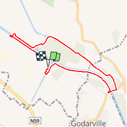
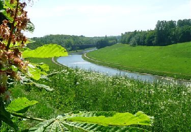
Randonnée Marche nordique de 7,3 km à découvrir à Wallonie, Hainaut, Seneffe. Cette randonnée est proposée par Bilboquet.
Description
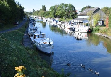
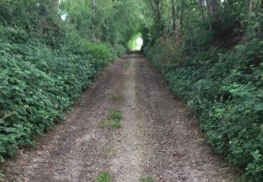
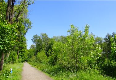
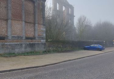
Parcours le long du nouveau et ancien canal Bruxelles-Charleroi. Tunnel de la Bête Refaite et le Tunnel de Godarville. Les 2 tunnels sont d'accès interdit ! Danger
Localisation
Pays :
Belgique
Région :
Wallonie
Département/Province :
Hainaut
Commune :
Seneffe
Localité :
Seneffe
Départ:(Dec)
Départ:(UTM)
590241 ; 5595884 (31U) N.
Commentaires
Randonnées à proximité
![Randonnée Marche Chapelle-lez-Herlaimont - RL-GG-07_Godarville_Piéton - Photo](https://media.geolcdn.com/t/375/260/98f383e1-513d-40e1-89f6-7cac4611f0b0.jpg&format=jpg&maxdim=2)
![Marche Marche](https://static1.geolcdn.com/sitytour/trail-icons/101.png)
RL-GG-07_Godarville_Piéton
Marche
Très difficile
(4)
Chapelle-lez-Herlaimont,
Wallonie,
Hainaut,
Belgique
![](/images/other/stat-length.png)
18,8 km | 22 km-effort
4h 50min
![](https://static1.geolcdn.com/siteimages/upload/files/16400158638029165_repeat_loop_refresh_sync_direction_icon.png)
Non
![Marche Marche](https://static1.geolcdn.com/sitytour/trail-icons/101.png)
BE-Pont-à-Celles - Autour du ruisseau de Rosseignies
Marche
Facile
(2)
Pont-à-Celles,
Wallonie,
Hainaut,
Belgique
![](/images/other/stat-length.png)
7,6 km | 8,5 km-effort
1h 49min
![](https://static1.geolcdn.com/siteimages/upload/files/16400158638029165_repeat_loop_refresh_sync_direction_icon.png)
Oui
![Randonnée Marche Morlanwelz - Balade dans le Parc et le Bois de Mariemont - Photo](https://media.geolcdn.com/t/375/260/ext.jpg?maxdim=2&url=https%3A%2F%2Fservices.sitytrail.com%2FGeolivesWS%2FDownloadMedia.ashx%3FTrailID%3D194631%26Media%3D8d7b7fc5-39c0-42de-b5bd-02b875ee162a.JPG)
![Marche Marche](https://static1.geolcdn.com/sitytour/trail-icons/101.png)
Balade dans le Parc et le Bois de Mariemont
Marche
Très facile
(3)
Morlanwelz,
Wallonie,
Hainaut,
Belgique
![](/images/other/stat-length.png)
6,4 km | 8,2 km-effort
1h 45min
![](https://static1.geolcdn.com/siteimages/upload/files/16400158638029165_repeat_loop_refresh_sync_direction_icon.png)
Oui
![Randonnée Marche Seneffe - Balade à Seneffe - Photo](https://media.geolcdn.com/t/375/260/ext.jpg?maxdim=2&url=https%3A%2F%2Fservices.sitytrail.com%2FGeolivesWS%2FDownloadMedia.ashx%3FTrailID%3D130913%26Media%3Daf2f3e93-dc12-469c-a2a0-cc8e44dbe239.JPG)
![Marche Marche](https://static1.geolcdn.com/sitytour/trail-icons/101.png)
Balade à Seneffe
Marche
Facile
(3)
Seneffe,
Wallonie,
Hainaut,
Belgique
![](/images/other/stat-length.png)
11,4 km | 12,9 km-effort
3h 0min
![](https://static1.geolcdn.com/siteimages/upload/files/16400158638029165_repeat_loop_refresh_sync_direction_icon.png)
Oui
![Randonnée A pied Chapelle-lez-Herlaimont - SJC3 janv.2022 - Photo](https://media.geolcdn.com/t/375/260/950a982d-3321-4daa-a54e-58b133185e85.jpg&format=jpg&maxdim=2)
![A pied A pied](https://static1.geolcdn.com/sitytour/trail-icons/100.png)
SJC3 janv.2022
A pied
Moyen
(1)
Chapelle-lez-Herlaimont,
Wallonie,
Hainaut,
Belgique
![](/images/other/stat-length.png)
18,2 km | 22 km-effort
5h 1min
![](https://static1.geolcdn.com/siteimages/upload/files/16400158638029165_repeat_loop_refresh_sync_direction_icon.png)
Non
![Marche Marche](https://static1.geolcdn.com/sitytour/trail-icons/101.png)
BE-Seneffe - Château de Seneffe - l'Ancien canal
Marche
Moyen
(1)
Seneffe,
Wallonie,
Hainaut,
Belgique
![](/images/other/stat-length.png)
6,6 km | 7,7 km-effort
1h 41min
![](https://static1.geolcdn.com/siteimages/upload/files/16400158638029165_repeat_loop_refresh_sync_direction_icon.png)
Oui
![Randonnée Marche Manage - Le Bois de Mariemont et la vallee de Scailmont - Photo](https://media.geolcdn.com/t/375/260/ext.jpg?maxdim=2&url=https%3A%2F%2Fstatic1.geolcdn.com%2Fsiteimages%2Fupload%2Ffiles%2F1553511878bg_sport_marche.png)
![Marche Marche](https://static1.geolcdn.com/sitytour/trail-icons/101.png)
Le Bois de Mariemont et la vallee de Scailmont
Marche
Facile
(3)
Manage,
Wallonie,
Hainaut,
Belgique
![](/images/other/stat-length.png)
11,9 km | 14,5 km-effort
3h 0min
![](https://static1.geolcdn.com/siteimages/upload/files/16400158638029165_repeat_loop_refresh_sync_direction_icon.png)
Oui
![Randonnée Marche Manage - Balade dans le Bois de Scailmont - Manage - Photo](https://media.geolcdn.com/t/375/260/8e7fecb2-020c-475a-81cb-336ed33dd691.jpeg&format=jpg&maxdim=2)
![Marche Marche](https://static1.geolcdn.com/sitytour/trail-icons/101.png)
Balade dans le Bois de Scailmont - Manage
Marche
Moyen
(3)
Manage,
Wallonie,
Hainaut,
Belgique
![](/images/other/stat-length.png)
5,6 km | 6,7 km-effort
1h 31min
![](https://static1.geolcdn.com/siteimages/upload/files/16400158638029165_repeat_loop_refresh_sync_direction_icon.png)
Oui
![Randonnée Marche Seneffe - Autour du canal du centre et vieux canal - Photo](https://media.geolcdn.com/t/375/260/ext.jpg?maxdim=2&url=https%3A%2F%2Fstatic1.geolcdn.com%2Fsiteimages%2Fupload%2Ffiles%2F1553511878bg_sport_marche.png)
![Marche Marche](https://static1.geolcdn.com/sitytour/trail-icons/101.png)
Autour du canal du centre et vieux canal
Marche
Très difficile
(1)
Seneffe,
Wallonie,
Hainaut,
Belgique
![](/images/other/stat-length.png)
17,7 km | 19,9 km-effort
3h 26min
![](https://static1.geolcdn.com/siteimages/upload/files/16400158638029165_repeat_loop_refresh_sync_direction_icon.png)
Oui