![](/images/other/stat-length.png)
![Randonnée Marche Damvix - La Venise Verte : Damvix - Saint-Hilaire-la-Palud - Arçais - Photo](https://media.geolcdn.com/t/1900/400/ext.pjpeg?maxdim=2&url=https%3A%2F%2Fstatic1.geolcdn.com%2Fsiteimages%2Fupload%2Ffiles%2F1553511878bg_sport_marche.png)
La Venise Verte : Damvix - Saint-Hilaire-la-Palud - Arçais
neoroll44
Utilisateur
![Longueur](/images/other/stat-length.png)
![Altitude max](https://static1.geolcdn.com/siteimages/upload/files/1508320355ic_sort_altitude_max_24dp.png)
![Dénivelé positif](https://static1.geolcdn.com/siteimages/upload/files/1508320355ic_sort_den_pos_24dp.png)
![Km-Effort](/images/other/stat-length.png)
![Altitude min](https://static1.geolcdn.com/siteimages/upload/files/1508320355ic_sort_altitude_min_24dp.png)
![Dénivelé négatif](https://static1.geolcdn.com/siteimages/upload/files/1508320355ic_sort_den_neg_24dp.png)
![Boucle](https://static1.geolcdn.com/siteimages/upload/files/16400158638029165_repeat_loop_refresh_sync_direction_icon.png)
![Marche](https://static1.geolcdn.com/sitytour/trail-icons/101.png)
3h23
Difficulté : Difficile
![Scannez ce code QR pour ouvrir la randonnée dans l'application SityTrail](https://capi.geolives.com/qq0zvz2zws4bq2lad0pu/sitytour/trails/2074671/qr.png?size=200)
Application GPS de randonnée GRATUITE
À propos
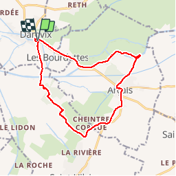
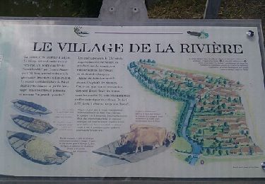
Randonnée Marche de 14,3 km à découvrir à Pays de la Loire, Vendée, Damvix. Cette randonnée est proposée par neoroll44.
Description
Se garer sur un des parking à proximité de l'embarcadère des Conches à Damvix sur la D104.
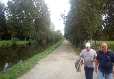
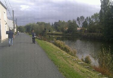
(D/A) Au panneau de sortie du village, prendre à droite en direction du Camping des Conches, Rue du Grand Port. Poursuivre toujours tout droit jusqu'à rejoindre un pont traversant le canal de la Grande Rigole ou de la Garette. Traverser le pont et continuer toujours tout droit.
(1) A un carrefour en T à 300 mètres du pont, prendre à gauche. Continuer en restant sur le chemin pédestre principal (chemin blanc large).
(2) Aux premières habitations du carrefour de la Devise, tourner à gauche en direction d'Arçais.
(3) Rejoindre et emprunter la piste cyclable qui longe la D101 sur une centaine de mètres.
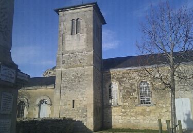
(4) Prendre ensuite à gauche la piste cyclable au niveau d'un panneau "impasse" pour rejoindre le centre d'Arçais par la Rue du Coursault. Au croisement avec la D102, virer à gauche puis encore à gauche au croisement qui suit pour passer devant l'église et rejoindre la Rue du Grand Port.
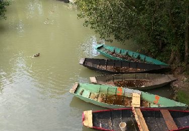
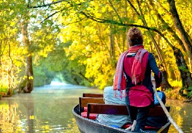
(5) Au niveau de la location de barques, bifurquer à droite et longer le Bief de la Garenne en direction du Nord- Est. A l'intersection au niveau d'un pont continuer en face sur le chemin du Bief Minet pour rejoindre la Sèvre Niortaise. Faire environ 300 mètres jusqu'à une "barque à chaîne " indiquée sur un panneau.
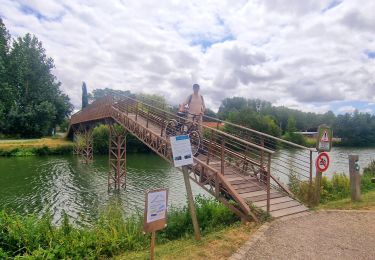
(6) Emprunter la barque à chaîne pour traverser. Une fois sur l'autre rive, virer à gauche pour longer la Sèvre jusqu'aux écluses de Damvix.
Rejoindre ensuite le départ en retraversant la Sèvre (D/A).
Localisation
Commentaires
Randonnées à proximité
![Randonnée Marche Saint-Hilaire-la-Palud - Randonnée dans le marais poitevin autour de St Hilaire La Palud - Photo](https://media.geolcdn.com/t/375/260/ext.jpg?maxdim=2&url=https%3A%2F%2Fservices.sitytrail.com%2FGeolivesWS%2FDownloadMedia.ashx%3FTrailID%3D813254%26Media%3Dfix__20170819172209.jpg)
![Marche Marche](https://static1.geolcdn.com/sitytour/trail-icons/101.png)
Marche
![](/images/other/stat-length.png)
![](https://static1.geolcdn.com/siteimages/upload/files/16400158638029165_repeat_loop_refresh_sync_direction_icon.png)
![Randonnée Marche Arçais - Arçais - Photo](https://media.geolcdn.com/t/375/260/ext.jpg?maxdim=2&url=https%3A%2F%2Fservices.sitytrail.com%2FGeolivesWS%2FDownloadMedia.ashx%3FTrailID%3D154286%26Media%3D20120918154346.jpeg)
![Marche Marche](https://static1.geolcdn.com/sitytour/trail-icons/101.png)
Marche
![](/images/other/stat-length.png)
![](https://static1.geolcdn.com/siteimages/upload/files/16400158638029165_repeat_loop_refresh_sync_direction_icon.png)
![Randonnée V.T.C. Le Mazeau - Cyclo dans le marais Poitevin - Photo](https://media.geolcdn.com/t/375/260/86905f3c-566b-4bf0-9e35-0be64feae71f.jpg&format=jpg&maxdim=2)
![V.T.C. V.T.C.](https://static1.geolcdn.com/sitytour/trail-icons/203.png)
V.T.C.
![](/images/other/stat-length.png)
![](https://static1.geolcdn.com/siteimages/upload/files/16400158638029165_repeat_loop_refresh_sync_direction_icon.png)
![Randonnée Vélo Maillé - Les Ecluses, Maillé, Damvix - Photo](https://media.geolcdn.com/t/375/260/ext.jpg?maxdim=2&url=https%3A%2F%2Fstatic1.geolcdn.com%2Fsiteimages%2Fupload%2Ffiles%2F1524743154velo.jpg)
![Vélo Vélo](https://static1.geolcdn.com/sitytour/trail-icons/200.png)
Vélo
![](/images/other/stat-length.png)
![](https://static1.geolcdn.com/siteimages/upload/files/16400158638029165_repeat_loop_refresh_sync_direction_icon.png)
![Randonnée Marche Le Mazeau - Mazeau_Marais_Sauvage - Photo](https://media.geolcdn.com/t/375/260/c928f69a-d8cb-467b-bfde-89b85eb625c6.jpg&format=jpg&maxdim=2)
![Marche Marche](https://static1.geolcdn.com/sitytour/trail-icons/101.png)
Marche
![](/images/other/stat-length.png)
![](https://static1.geolcdn.com/siteimages/upload/files/16400158638029165_repeat_loop_refresh_sync_direction_icon.png)
![Randonnée Marche Le Mazeau - Le Mazeau 1 - Photo](https://media.geolcdn.com/t/375/260/ext.jpg?maxdim=2&url=https%3A%2F%2Fservices.sitytrail.com%2FGeolivesWS%2FDownloadMedia.ashx%3FTrailID%3D843604%26Media%3Dfix__20171010154548.jpg)
![Marche Marche](https://static1.geolcdn.com/sitytour/trail-icons/101.png)
Marche
![](/images/other/stat-length.png)
![](https://static1.geolcdn.com/siteimages/upload/files/16400158638029165_repeat_loop_refresh_sync_direction_icon.png)
![Randonnée Marche Saint-Sigismond - saint-Sigismond - Photo](https://media.geolcdn.com/t/375/260/ext.jpg?maxdim=2&url=https%3A%2F%2Fservices.sitytrail.com%2FGeolivesWS%2FDownloadMedia.ashx%3FTrailID%3D165225%26Media%3D20121204154143.jpeg)
![Marche Marche](https://static1.geolcdn.com/sitytour/trail-icons/101.png)
Marche
![](/images/other/stat-length.png)
![](https://static1.geolcdn.com/siteimages/upload/files/16400158638029165_repeat_loop_refresh_sync_direction_icon.png)
![Randonnée Marche Damvix - Danvix -(9,5km) - Photo](https://media.geolcdn.com/t/375/260/ext.jpg?maxdim=2&url=https%3A%2F%2Fservices.sitytrail.com%2FGeolivesWS%2FDownloadMedia.ashx%3FTrailID%3D156427%26Media%3D20121002162418.jpeg)
![Marche Marche](https://static1.geolcdn.com/sitytour/trail-icons/101.png)
Marche
![](/images/other/stat-length.png)
![](https://static1.geolcdn.com/siteimages/upload/files/16400158638029165_repeat_loop_refresh_sync_direction_icon.png)
![Randonnée Marche Saint-Hilaire-la-Palud - St hilaire la palud - Photo](https://media.geolcdn.com/t/375/260/ext.jpg?maxdim=2&url=https%3A%2F%2Fservices.sitytrail.com%2FGeolivesWS%2FDownloadMedia.ashx%3FTrailID%3D135771%26Media%3D20120626161947.jpeg)
![Marche Marche](https://static1.geolcdn.com/sitytour/trail-icons/101.png)
Marche
![](/images/other/stat-length.png)
![](https://static1.geolcdn.com/siteimages/upload/files/16400158638029165_repeat_loop_refresh_sync_direction_icon.png)