![](/images/other/stat-length.png)
![Randonnée Marche Surgères - Chemin de St Jacques de Compostelle- de Surgères à Puyrolland - Photo](https://media.geolcdn.com/t/1900/400/e69f720f-7d39-4b4c-b2db-da5bf652f3b9.jpg&format=pjpeg&maxdim=2)
Chemin de St Jacques de Compostelle- de Surgères à Puyrolland
Patmobil
Utilisateur
![Longueur](/images/other/stat-length.png)
Longueur
17,4 km
![Altitude max](https://static1.geolcdn.com/siteimages/upload/files/1508320355ic_sort_altitude_max_24dp.png)
Altitude max
50 m
![Dénivelé positif](https://static1.geolcdn.com/siteimages/upload/files/1508320355ic_sort_den_pos_24dp.png)
Dénivelé positif
125 m
![Km-Effort](/images/other/stat-length.png)
Km-Effort
19 km
![Altitude min](https://static1.geolcdn.com/siteimages/upload/files/1508320355ic_sort_altitude_min_24dp.png)
Altitude min
7 m
![Dénivelé négatif](https://static1.geolcdn.com/siteimages/upload/files/1508320355ic_sort_den_neg_24dp.png)
Dénivelé négatif
114 m
![Boucle](https://static1.geolcdn.com/siteimages/upload/files/16400158638029165_repeat_loop_refresh_sync_direction_icon.png)
Boucle
Non
Date de création :
2019-05-07 08:35:05.403
Dernière modification :
2019-09-16 08:14:09.977
![Marche](https://static1.geolcdn.com/sitytour/trail-icons/101.png)
3h31
Difficulté : Moyen
![Scannez ce code QR pour ouvrir la randonnée dans l'application SityTrail](https://capi.geolives.com/qq0zvz2zws4bq2lad0pu/sitytour/trails/2074038/qr.png?size=200)
Application GPS de randonnée GRATUITE
À propos
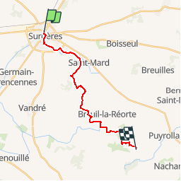
Randonnée Marche de 17,4 km à découvrir à Nouvelle-Aquitaine, Charente-Maritime, Surgères. Cette randonnée est proposée par Patmobil.
Description
Nouveau balisage réalisé par le département de Charente Maritime, inauguré le 15 septembre 2019 par l'Association "Le Bourdon 17"
Localisation
Pays :
France
Région :
Nouvelle-Aquitaine
Département/Province :
Charente-Maritime
Commune :
Surgères
Localité :
Unknown
Départ:(Dec)
Départ:(UTM)
673738 ; 5108462 (30T) N.
Commentaires
Randonnées à proximité
![Randonnée Marche Surgères - surgeres la ville au moine - Photo](https://media.geolcdn.com/t/375/260/ext.jpg?maxdim=2&url=https%3A%2F%2Fstatic1.geolcdn.com%2Fsiteimages%2Fupload%2Ffiles%2F1553511878bg_sport_marche.png)
![Marche Marche](https://static1.geolcdn.com/sitytour/trail-icons/101.png)
surgeres la ville au moine
Marche
Facile
Surgères,
Nouvelle-Aquitaine,
Charente-Maritime,
France
![](/images/other/stat-length.png)
17,7 km | 19,5 km-effort
3h 57min
![](https://static1.geolcdn.com/siteimages/upload/files/16400158638029165_repeat_loop_refresh_sync_direction_icon.png)
Non
![Randonnée Marche Vouhé - vouhe - Photo](https://media.geolcdn.com/t/375/260/ext.jpg?maxdim=2&url=https%3A%2F%2Fstatic1.geolcdn.com%2Fsiteimages%2Fupload%2Ffiles%2F1553511878bg_sport_marche.png)
![Marche Marche](https://static1.geolcdn.com/sitytour/trail-icons/101.png)
vouhe
Marche
Moyen
Vouhé,
Nouvelle-Aquitaine,
Charente-Maritime,
France
![](/images/other/stat-length.png)
6,4 km | 7 km-effort
1h 36min
![](https://static1.geolcdn.com/siteimages/upload/files/16400158638029165_repeat_loop_refresh_sync_direction_icon.png)
Oui
![Randonnée Marche Vouhé - ggff - Photo](https://media.geolcdn.com/t/375/260/ext.jpg?maxdim=2&url=https%3A%2F%2Fstatic1.geolcdn.com%2Fsiteimages%2Fupload%2Ffiles%2F1553511878bg_sport_marche.png)
![Marche Marche](https://static1.geolcdn.com/sitytour/trail-icons/101.png)
ggff
Marche
Moyen
Vouhé,
Nouvelle-Aquitaine,
Charente-Maritime,
France
![](/images/other/stat-length.png)
7 km | 7,5 km-effort
2h 2min
![](https://static1.geolcdn.com/siteimages/upload/files/16400158638029165_repeat_loop_refresh_sync_direction_icon.png)
Oui
![Randonnée Marche Vouhé - Vouhe - Photo](https://media.geolcdn.com/t/375/260/ext.jpg?maxdim=2&url=https%3A%2F%2Fstatic1.geolcdn.com%2Fsiteimages%2Fupload%2Ffiles%2F1553511878bg_sport_marche.png)
![Marche Marche](https://static1.geolcdn.com/sitytour/trail-icons/101.png)
Vouhe
Marche
Moyen
Vouhé,
Nouvelle-Aquitaine,
Charente-Maritime,
France
![](/images/other/stat-length.png)
6,1 km | 6,5 km-effort
1h 30min
![](https://static1.geolcdn.com/siteimages/upload/files/16400158638029165_repeat_loop_refresh_sync_direction_icon.png)
Oui
![Randonnée Marche Vouhé - vouhe - Photo](https://media.geolcdn.com/t/375/260/ext.jpg?maxdim=2&url=https%3A%2F%2Fstatic1.geolcdn.com%2Fsiteimages%2Fupload%2Ffiles%2F1553511878bg_sport_marche.png)
![Marche Marche](https://static1.geolcdn.com/sitytour/trail-icons/101.png)
vouhe
Marche
Moyen
Vouhé,
Nouvelle-Aquitaine,
Charente-Maritime,
France
![](/images/other/stat-length.png)
6,6 km | 7 km-effort
3h 36min
![](https://static1.geolcdn.com/siteimages/upload/files/16400158638029165_repeat_loop_refresh_sync_direction_icon.png)
Oui
![Randonnée Randonnée équestre Vouhé - Forêt gilan - Photo](https://media.geolcdn.com/t/375/260/ext.jpg?maxdim=2&url=https%3A%2F%2Fstatic1.geolcdn.com%2Fsiteimages%2Fupload%2Ffiles%2F1524743154cheval.jpg)
![Randonnée équestre Randonnée équestre](https://static1.geolcdn.com/sitytour/trail-icons/301.png)
Forêt gilan
Randonnée équestre
Vouhé,
Nouvelle-Aquitaine,
Charente-Maritime,
France
![](/images/other/stat-length.png)
11,3 km | 12,1 km-effort
2h 28min
![](https://static1.geolcdn.com/siteimages/upload/files/16400158638029165_repeat_loop_refresh_sync_direction_icon.png)
Non
![Randonnée Marche Vouhé - vpuhe - Photo](https://media.geolcdn.com/t/375/260/ext.jpg?maxdim=2&url=https%3A%2F%2Fstatic1.geolcdn.com%2Fsiteimages%2Fupload%2Ffiles%2F1553511878bg_sport_marche.png)
![Marche Marche](https://static1.geolcdn.com/sitytour/trail-icons/101.png)
vpuhe
Marche
Moyen
Vouhé,
Nouvelle-Aquitaine,
Charente-Maritime,
France
![](/images/other/stat-length.png)
9,2 km | 9,8 km-effort
2h 6min
![](https://static1.geolcdn.com/siteimages/upload/files/16400158638029165_repeat_loop_refresh_sync_direction_icon.png)
Oui
![Randonnée Marche Saint-Pierre-la-Noue - saint Germain de Marencennes 17 - Photo](https://media.geolcdn.com/t/375/260/ext.jpg?maxdim=2&url=https%3A%2F%2Fstatic1.geolcdn.com%2Fsiteimages%2Fupload%2Ffiles%2F1553511878bg_sport_marche.png)
![Marche Marche](https://static1.geolcdn.com/sitytour/trail-icons/101.png)
saint Germain de Marencennes 17
Marche
Moyen
Saint-Pierre-la-Noue,
Nouvelle-Aquitaine,
Charente-Maritime,
France
![](/images/other/stat-length.png)
9,2 km | 9,8 km-effort
2h 31min
![](https://static1.geolcdn.com/siteimages/upload/files/16400158638029165_repeat_loop_refresh_sync_direction_icon.png)
Oui
![Randonnée Marche Vouhé - g - Photo](https://media.geolcdn.com/t/375/260/ext.jpg?maxdim=2&url=https%3A%2F%2Fstatic1.geolcdn.com%2Fsiteimages%2Fupload%2Ffiles%2F1553511878bg_sport_marche.png)
![Marche Marche](https://static1.geolcdn.com/sitytour/trail-icons/101.png)
g
Marche
Très facile
Vouhé,
Nouvelle-Aquitaine,
Charente-Maritime,
France
![](/images/other/stat-length.png)
5,5 km | 5,9 km-effort
1h 20min
![](https://static1.geolcdn.com/siteimages/upload/files/16400158638029165_repeat_loop_refresh_sync_direction_icon.png)
Oui