![](/images/other/stat-length.png)
![Randonnée Vélo Dour - Dour Festival 2019 - 1 - Brasserie de Blaugies - Photo](https://media.geolcdn.com/t/1900/400/eac47ea7-3180-40af-be68-e0cb75b409a6.jpg&format=pjpeg&maxdim=2)
Dour Festival 2019 - 1 - Brasserie de Blaugies
CorentinM
Utilisateur
![Longueur](/images/other/stat-length.png)
Longueur
26 km
![Altitude max](https://static1.geolcdn.com/siteimages/upload/files/1508320355ic_sort_altitude_max_24dp.png)
Altitude max
160 m
![Dénivelé positif](https://static1.geolcdn.com/siteimages/upload/files/1508320355ic_sort_den_pos_24dp.png)
Dénivelé positif
201 m
![Km-Effort](/images/other/stat-length.png)
Km-Effort
29 km
![Altitude min](https://static1.geolcdn.com/siteimages/upload/files/1508320355ic_sort_altitude_min_24dp.png)
Altitude min
45 m
![Dénivelé négatif](https://static1.geolcdn.com/siteimages/upload/files/1508320355ic_sort_den_neg_24dp.png)
Dénivelé négatif
201 m
![Boucle](https://static1.geolcdn.com/siteimages/upload/files/16400158638029165_repeat_loop_refresh_sync_direction_icon.png)
Boucle
Oui
Date de création :
2019-05-06 09:59:04.28
Dernière modification :
2019-06-27 14:00:24.873
![Vélo](https://static1.geolcdn.com/sitytour/trail-icons/200.png)
--
Difficulté : Très facile
![Scannez ce code QR pour ouvrir la randonnée dans l'application SityTrail](https://capi.geolives.com/qq0zvz2zws4bq2lad0pu/sitytour/trails/2073089/qr.png?size=200)
Application GPS de randonnée GRATUITE
À propos
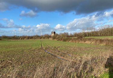
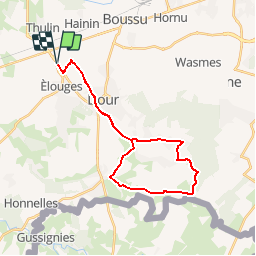
Randonnée Vélo de 26 km à découvrir à Wallonie, Hainaut, Dour. Cette randonnée est proposée par CorentinM.
Description
Randonnée Vhello - Le réseau Points-Noeuds du Coeur du Hainaut.
N° à suivre : 84 - 19 - 6 - 15 - 5 - 1 - 40 -19 - 84
Arrêt à la Brasserie de Blaugies un peu avant le PN 5.
Localisation
Pays :
Belgique
Région :
Wallonie
Département/Province :
Hainaut
Commune :
Dour
Localité :
Élouges
Départ:(Dec)
Départ:(UTM)
553247 ; 5584840 (31U) N.
Commentaires
Randonnées à proximité
![Randonnée Marche Honnelles - Balade à Montignies-sur-Roc - Photo](https://media.geolcdn.com/t/375/260/ext.jpg?maxdim=2&url=https%3A%2F%2Fservices.sitytrail.com%2FGeolivesWS%2FDownloadMedia.ashx%3FTrailID%3D165049%26Media%3D610078ec-e9f2-44b7-9b5f-69fed8ead538.JPG)
![Marche Marche](https://static1.geolcdn.com/sitytour/trail-icons/101.png)
Balade à Montignies-sur-Roc
Marche
Très facile
(1)
Honnelles,
Wallonie,
Hainaut,
Belgique
![](/images/other/stat-length.png)
8 km | 9,4 km-effort
2h 3min
![](https://static1.geolcdn.com/siteimages/upload/files/16400158638029165_repeat_loop_refresh_sync_direction_icon.png)
Oui
![Randonnée Marche Hensies - Saint antoine - Photo](https://media.geolcdn.com/t/375/260/68464df3-0511-4919-8aef-a7e2cd002968.jpg&format=jpg&maxdim=2)
![Marche Marche](https://static1.geolcdn.com/sitytour/trail-icons/101.png)
Saint antoine
Marche
Très facile
(1)
Hensies,
Wallonie,
Hainaut,
Belgique
![](/images/other/stat-length.png)
7,5 km | 9,2 km-effort
1h 58min
![](https://static1.geolcdn.com/siteimages/upload/files/16400158638029165_repeat_loop_refresh_sync_direction_icon.png)
Oui
![Randonnée Marche nordique Dour - Mielikki marche nordique - Dour (Oxfam) 2025 - Parcours long - Photo](https://media.geolcdn.com/t/375/260/ext.jpg?maxdim=2&url=https%3A%2F%2Fstatic1.geolcdn.com%2Fsiteimages%2Fupload%2Ffiles%2F1545311037marcheuse_200dpi.jpg)
![Marche nordique Marche nordique](https://static1.geolcdn.com/sitytour/trail-icons/102.png)
Mielikki marche nordique - Dour (Oxfam) 2025 - Parcours long
Marche nordique
Moyen
(1)
Dour,
Wallonie,
Hainaut,
Belgique
![](/images/other/stat-length.png)
9,2 km | 10,7 km-effort
2h 0min
![](https://static1.geolcdn.com/siteimages/upload/files/16400158638029165_repeat_loop_refresh_sync_direction_icon.png)
Oui
![Randonnée A pied Honnelles - 2021-04-08 17_40_04 - Marche 12,552 km - Photo](https://media.geolcdn.com/t/375/260/ext.jpg?maxdim=2&url=https%3A%2F%2Fstatic1.geolcdn.com%2Fsiteimages%2Fupload%2Ffiles%2F1545311037marcheuse_200dpi.jpg)
![A pied A pied](https://static1.geolcdn.com/sitytour/trail-icons/100.png)
2021-04-08 17_40_04 - Marche 12,552 km
A pied
Facile
(1)
Honnelles,
Wallonie,
Hainaut,
Belgique
![](/images/other/stat-length.png)
13,3 km | 15,2 km-effort
3h 27min
![](https://static1.geolcdn.com/siteimages/upload/files/16400158638029165_repeat_loop_refresh_sync_direction_icon.png)
Oui
![Randonnée Marche Boussu - Boussu-Ravel-SaintGhislain - Photo](https://media.geolcdn.com/t/375/260/ext.jpg?maxdim=2&url=https%3A%2F%2Fstatic1.geolcdn.com%2Fsiteimages%2Fupload%2Ffiles%2F1553511878bg_sport_marche.png)
![Marche Marche](https://static1.geolcdn.com/sitytour/trail-icons/101.png)
Boussu-Ravel-SaintGhislain
Marche
Facile
(1)
Boussu,
Wallonie,
Hainaut,
Belgique
![](/images/other/stat-length.png)
7,2 km | 7,8 km-effort
1h 43min
![](https://static1.geolcdn.com/siteimages/upload/files/16400158638029165_repeat_loop_refresh_sync_direction_icon.png)
Oui
![Randonnée Marche Dour - Le triangle des steriles1 - Photo](https://media.geolcdn.com/t/375/260/ext.jpg?maxdim=2&url=https%3A%2F%2Fstatic1.geolcdn.com%2Fsiteimages%2Fupload%2Ffiles%2F1553511878bg_sport_marche.png)
![Marche Marche](https://static1.geolcdn.com/sitytour/trail-icons/101.png)
Le triangle des steriles1
Marche
Facile
(2)
Dour,
Wallonie,
Hainaut,
Belgique
![](/images/other/stat-length.png)
8 km | 9,3 km-effort
2h 2min
![](https://static1.geolcdn.com/siteimages/upload/files/16400158638029165_repeat_loop_refresh_sync_direction_icon.png)
Oui
![Randonnée Marche Dour - chaga - Photo](https://media.geolcdn.com/t/375/260/5abbeb16-c742-4427-b917-f331ee6c648c.jpg&format=jpg&maxdim=2)
![Marche Marche](https://static1.geolcdn.com/sitytour/trail-icons/101.png)
![Randonnée Marche Bernissart - harchies 170922 - Photo](https://media.geolcdn.com/t/375/260/c6968da4-f26b-4aa1-bee4-ebf7a684799a.jpg&format=jpg&maxdim=2)
![Marche Marche](https://static1.geolcdn.com/sitytour/trail-icons/101.png)
harchies 170922
Marche
Très facile
Bernissart,
Wallonie,
Hainaut,
Belgique
![](/images/other/stat-length.png)
5,1 km | 5,6 km-effort
1h 47min
![](https://static1.geolcdn.com/siteimages/upload/files/16400158638029165_repeat_loop_refresh_sync_direction_icon.png)
Oui
![Randonnée Marche Dour - Wiherie 18,4 km - Photo](https://media.geolcdn.com/t/375/260/13f6bedb-34d6-4db9-b3df-1b0c5bc3b138.jpg&format=jpg&maxdim=2)
![Marche Marche](https://static1.geolcdn.com/sitytour/trail-icons/101.png)