![](/images/other/stat-length.png)
![Randonnée Randonnée équestre Saintes-Maries-de-la-Mer - 2019-05-04 Rando CVA Camargue Bac Sauvage - Photo](https://media.geolcdn.com/t/1900/400/85ec7dde-6873-4a53-b337-f81a0d7c72f8.jpg&format=pjpeg&maxdim=2)
2019-05-04 Rando CVA Camargue Bac Sauvage
holtzv
Utilisateur GUIDE
![Longueur](/images/other/stat-length.png)
Longueur
24 km
![Altitude max](https://static1.geolcdn.com/siteimages/upload/files/1508320355ic_sort_altitude_max_24dp.png)
Altitude max
6 m
![Dénivelé positif](https://static1.geolcdn.com/siteimages/upload/files/1508320355ic_sort_den_pos_24dp.png)
Dénivelé positif
57 m
![Km-Effort](/images/other/stat-length.png)
Km-Effort
25 km
![Altitude min](https://static1.geolcdn.com/siteimages/upload/files/1508320355ic_sort_altitude_min_24dp.png)
Altitude min
-3 m
![Dénivelé négatif](https://static1.geolcdn.com/siteimages/upload/files/1508320355ic_sort_den_neg_24dp.png)
Dénivelé négatif
57 m
![Boucle](https://static1.geolcdn.com/siteimages/upload/files/16400158638029165_repeat_loop_refresh_sync_direction_icon.png)
Boucle
Oui
Date de création :
2019-05-04 08:17:47.941
Dernière modification :
2019-05-06 09:17:40.388
![Randonnée équestre](https://static1.geolcdn.com/sitytour/trail-icons/301.png)
4h17
Difficulté : Très facile
![Scannez ce code QR pour ouvrir la randonnée dans l'application SityTrail](https://capi.geolives.com/qq0zvz2zws4bq2lad0pu/sitytour/trails/2071965/qr.png?size=200)
Application GPS de randonnée GRATUITE
À propos
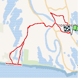
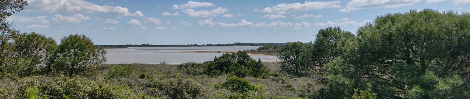
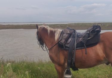
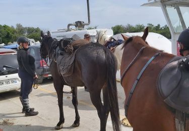
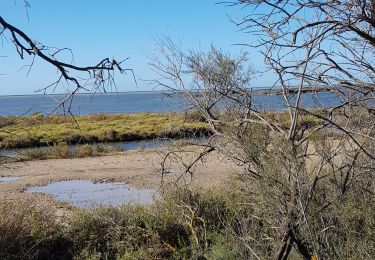
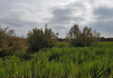
Randonnée Randonnée équestre de 24 km à découvrir à Provence-Alpes-Côte d'Azur, Bouches-du-Rhône, Saintes-Maries-de-la-Mer. Cette randonnée est proposée par holtzv.
Description
Accompagnement par un guide obligatoire (~80€ la journée)
Une belle journée avec des galops inoubliables
Localisation
Pays :
France
Région :
Provence-Alpes-Côte d'Azur
Département/Province :
Bouches-du-Rhône
Commune :
Saintes-Maries-de-la-Mer
Localité :
Unknown
Départ:(Dec)
Départ:(UTM)
613749 ; 4815095 (31T) N.
Commentaires
Randonnées à proximité
![Randonnée Marche Saintes-Maries-de-la-Mer - 2010-10-02 - 16h23m32 - Photo](https://media.geolcdn.com/t/375/260/ext.jpg?maxdim=2&url=https%3A%2F%2Fservices.sitytrail.com%2FGeolivesWS%2FDownloadMedia.ashx%3FTrailID%3D46750%26Media%3D20101002153510.jpg)
![Marche Marche](https://static1.geolcdn.com/sitytour/trail-icons/101.png)
2010-10-02 - 16h23m32
Marche
Très facile
(1)
Saintes-Maries-de-la-Mer,
Provence-Alpes-Côte d'Azur,
Bouches-du-Rhône,
France
![](/images/other/stat-length.png)
10,2 km | 10,5 km-effort
Inconnu
![](https://static1.geolcdn.com/siteimages/upload/files/16400158638029165_repeat_loop_refresh_sync_direction_icon.png)
Oui
![Randonnée A pied Saintes-Maries-de-la-Mer - Boucle entre les deux bras du Rhône - Photo](https://media.geolcdn.com/t/375/260/019d47f6-717c-4535-9173-c7d72b927b96.jpeg&format=jpg&maxdim=2)
![A pied A pied](https://static1.geolcdn.com/sitytour/trail-icons/100.png)
Boucle entre les deux bras du Rhône
A pied
Très difficile
Saintes-Maries-de-la-Mer,
Provence-Alpes-Côte d'Azur,
Bouches-du-Rhône,
France
![](/images/other/stat-length.png)
43 km | 45 km-effort
10h 10min
![](https://static1.geolcdn.com/siteimages/upload/files/16400158638029165_repeat_loop_refresh_sync_direction_icon.png)
Oui
![Randonnée Randonnée équestre Saintes-Maries-de-la-Mer - 2019-05-03 Rando CVA Camargue Saintes Plage Est - Photo](https://media.geolcdn.com/t/375/260/cfc008c3-0a6f-44a1-8919-057a8a2a2f24.jpg&format=jpg&maxdim=2)
![Randonnée équestre Randonnée équestre](https://static1.geolcdn.com/sitytour/trail-icons/301.png)
2019-05-03 Rando CVA Camargue Saintes Plage Est
Randonnée équestre
Très facile
Saintes-Maries-de-la-Mer,
Provence-Alpes-Côte d'Azur,
Bouches-du-Rhône,
France
![](/images/other/stat-length.png)
25 km | 26 km-effort
4h 18min
![](https://static1.geolcdn.com/siteimages/upload/files/16400158638029165_repeat_loop_refresh_sync_direction_icon.png)
Oui
![Randonnée Vélo de route Saintes-Maries-de-la-Mer - Sainte Marie Grau du Roi - Photo](https://media.geolcdn.com/t/375/260/4017256d-043d-4e81-b410-37223a52a354.jpg&format=jpg&maxdim=2)
![Vélo de route Vélo de route](https://static1.geolcdn.com/sitytour/trail-icons/201.png)
Sainte Marie Grau du Roi
Vélo de route
Très difficile
Saintes-Maries-de-la-Mer,
Provence-Alpes-Côte d'Azur,
Bouches-du-Rhône,
France
![](/images/other/stat-length.png)
85 km | 88 km-effort
7h 33min
![](https://static1.geolcdn.com/siteimages/upload/files/16400158638029165_repeat_loop_refresh_sync_direction_icon.png)
Oui
![Randonnée Marche Saintes-Maries-de-la-Mer - Les Saintes le 25 mars 2021 - Photo](https://media.geolcdn.com/t/375/260/f4757fd7-1c9f-4906-bb4f-17969f39b6bd.jpg&format=jpg&maxdim=2)
![Marche Marche](https://static1.geolcdn.com/sitytour/trail-icons/101.png)
Les Saintes le 25 mars 2021
Marche
Très facile
Saintes-Maries-de-la-Mer,
Provence-Alpes-Côte d'Azur,
Bouches-du-Rhône,
France
![](/images/other/stat-length.png)
10,2 km | 10,4 km-effort
2h 45min
![](https://static1.geolcdn.com/siteimages/upload/files/16400158638029165_repeat_loop_refresh_sync_direction_icon.png)
Oui
![Randonnée Marche Saintes-Maries-de-la-Mer - Saintes Marie de la Mer 26 09 2019 - Photo](https://media.geolcdn.com/t/375/260/a4490fe4-81ff-4639-86d6-a60dfb1c2f76.jpg&format=jpg&maxdim=2)
![Marche Marche](https://static1.geolcdn.com/sitytour/trail-icons/101.png)
Saintes Marie de la Mer 26 09 2019
Marche
Très facile
Saintes-Maries-de-la-Mer,
Provence-Alpes-Côte d'Azur,
Bouches-du-Rhône,
France
![](/images/other/stat-length.png)
19,1 km | 19,7 km-effort
6h 5min
![](https://static1.geolcdn.com/siteimages/upload/files/16400158638029165_repeat_loop_refresh_sync_direction_icon.png)
Non
![Randonnée Cyclotourisme Saintes-Maries-de-la-Mer - Stes Maries de la Mer - Sète - Photo](https://media.geolcdn.com/t/375/260/1603446c-8149-4569-9bc9-774fdee4d6a4.jpg&format=jpg&maxdim=2)
![Cyclotourisme Cyclotourisme](https://static1.geolcdn.com/sitytour/trail-icons/204.png)
Stes Maries de la Mer - Sète
Cyclotourisme
Difficile
Saintes-Maries-de-la-Mer,
Provence-Alpes-Côte d'Azur,
Bouches-du-Rhône,
France
![](/images/other/stat-length.png)
95 km | 100 km-effort
5h 53min
![](https://static1.geolcdn.com/siteimages/upload/files/16400158638029165_repeat_loop_refresh_sync_direction_icon.png)
Non
![Randonnée Randonnée équestre Saintes-Maries-de-la-Mer - 202411 boucle Cacharel depuis Maguelonne - Photo](https://media.geolcdn.com/t/375/260/ext.jpg?maxdim=2&url=https%3A%2F%2Fstatic1.geolcdn.com%2Fsiteimages%2Fupload%2Ffiles%2F1524743154cheval.jpg)
![Randonnée équestre Randonnée équestre](https://static1.geolcdn.com/sitytour/trail-icons/301.png)
202411 boucle Cacharel depuis Maguelonne
Randonnée équestre
Moyen
Saintes-Maries-de-la-Mer,
Provence-Alpes-Côte d'Azur,
Bouches-du-Rhône,
France
![](/images/other/stat-length.png)
26 km | 26 km-effort
4h 30min
![](https://static1.geolcdn.com/siteimages/upload/files/16400158638029165_repeat_loop_refresh_sync_direction_icon.png)
Oui
![Randonnée Marche - Saintes Maries de la mer - Photo](https://media.geolcdn.com/t/375/260/ext.jpg?maxdim=2&url=https%3A%2F%2Fstatic1.geolcdn.com%2Fsiteimages%2Fupload%2Ffiles%2F1553511878bg_sport_marche.png)
![Marche Marche](https://static1.geolcdn.com/sitytour/trail-icons/101.png)