![](/images/other/stat-length.png)
![Randonnée Marche Hambers - L'ARON MAYENNE DANS UN ECRIN - Photo](https://media.geolcdn.com/t/1900/400/ext.pjpeg?maxdim=2&url=https%3A%2F%2Fstatic1.geolcdn.com%2Fsiteimages%2Fupload%2Ffiles%2F1553511878bg_sport_marche.png)
L'ARON MAYENNE DANS UN ECRIN
les randos d'Olivier
partout a pied et en moto
![Longueur](/images/other/stat-length.png)
Longueur
23 km
![Altitude max](https://static1.geolcdn.com/siteimages/upload/files/1508320355ic_sort_altitude_max_24dp.png)
Altitude max
289 m
![Dénivelé positif](https://static1.geolcdn.com/siteimages/upload/files/1508320355ic_sort_den_pos_24dp.png)
Dénivelé positif
417 m
![Km-Effort](/images/other/stat-length.png)
Km-Effort
28 km
![Altitude min](https://static1.geolcdn.com/siteimages/upload/files/1508320355ic_sort_altitude_min_24dp.png)
Altitude min
153 m
![Dénivelé négatif](https://static1.geolcdn.com/siteimages/upload/files/1508320355ic_sort_den_neg_24dp.png)
Dénivelé négatif
418 m
![Boucle](https://static1.geolcdn.com/siteimages/upload/files/16400158638029165_repeat_loop_refresh_sync_direction_icon.png)
Boucle
Oui
Date de création :
2019-05-03 06:18:00.353
Dernière modification :
2019-05-03 06:23:12.313
![Marche](https://static1.geolcdn.com/sitytour/trail-icons/101.png)
6h09
Difficulté : Très difficile
![Scannez ce code QR pour ouvrir la randonnée dans l'application SityTrail](https://capi.geolives.com/qq0zvz2zws4bq2lad0pu/sitytour/trails/2071167/qr.png?size=200)
Application GPS de randonnée GRATUITE
À propos
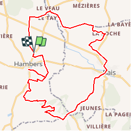
Randonnée Marche de 23 km à découvrir à Pays de la Loire, Mayenne, Hambers. Cette randonnée est proposée par les randos d'Olivier.
Description
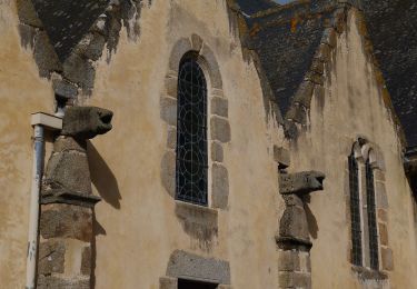
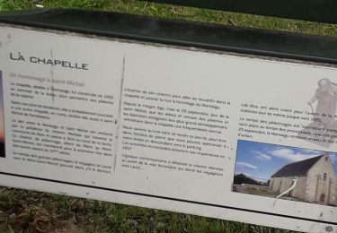
Un hameau du XVème siècle et une chapelle dédié à l'archange Michel... Panorama circulaire de la Haute-Mayenne et des Coëvrons... Ce circuit est à ne manquer sous aucun prétexte !
Localisation
Pays :
France
Région :
Pays de la Loire
Département/Province :
Mayenne
Commune :
Hambers
Localité :
Unknown
Départ:(Dec)
Départ:(UTM)
691941 ; 5348424 (30U) N.
Commentaires
Randonnées à proximité
![Randonnée A pied Bais - La Mayenne dans un écrin - Photo](https://media.geolcdn.com/t/375/260/819ab20d-9411-4256-a908-8776f3c1f631.jpeg&format=jpg&maxdim=2)
![A pied A pied](https://static1.geolcdn.com/sitytour/trail-icons/100.png)
La Mayenne dans un écrin
A pied
Moyen
Bais,
Pays de la Loire,
Mayenne,
France
![](/images/other/stat-length.png)
22 km | 27 km-effort
6h 12min
![](https://static1.geolcdn.com/siteimages/upload/files/16400158638029165_repeat_loop_refresh_sync_direction_icon.png)
Oui
![Randonnée A pied Bais - Balcon sur l'Aron - Photo](https://media.geolcdn.com/t/375/260/83c2ab66-6b3a-40f1-acba-ecff737de16b.jpeg&format=jpg&maxdim=2)
![A pied A pied](https://static1.geolcdn.com/sitytour/trail-icons/100.png)
Balcon sur l'Aron
A pied
Facile
Bais,
Pays de la Loire,
Mayenne,
France
![](/images/other/stat-length.png)
15,9 km | 20 km-effort
4h 32min
![](https://static1.geolcdn.com/siteimages/upload/files/16400158638029165_repeat_loop_refresh_sync_direction_icon.png)
Oui
![Randonnée Marche Hambers - Hambers Montaigu et retour - Photo](https://media.geolcdn.com/t/375/260/9985b358-fed6-4140-80f0-73e7344da834.jpg&format=jpg&maxdim=2)
![Marche Marche](https://static1.geolcdn.com/sitytour/trail-icons/101.png)
Hambers Montaigu et retour
Marche
Moyen
Hambers,
Pays de la Loire,
Mayenne,
France
![](/images/other/stat-length.png)
15 km | 18,6 km-effort
6h 11min
![](https://static1.geolcdn.com/siteimages/upload/files/16400158638029165_repeat_loop_refresh_sync_direction_icon.png)
Oui
![Randonnée Marche Bais - Bais Marche à pied - Photo](https://media.geolcdn.com/t/375/260/ext.jpg?maxdim=2&url=https%3A%2F%2Fstatic1.geolcdn.com%2Fsiteimages%2Fupload%2Ffiles%2F1553511878bg_sport_marche.png)
![Marche Marche](https://static1.geolcdn.com/sitytour/trail-icons/101.png)
Bais Marche à pied
Marche
Moyen
Bais,
Pays de la Loire,
Mayenne,
France
![](/images/other/stat-length.png)
22 km | 29 km-effort
6h 39min
![](https://static1.geolcdn.com/siteimages/upload/files/16400158638029165_repeat_loop_refresh_sync_direction_icon.png)
Non
![Randonnée Cheval Hambers - Les Chevaux du Montaigu_12_07_15 - Photo](https://media.geolcdn.com/t/375/260/ext.jpg?maxdim=2&url=https%3A%2F%2Fstatic1.geolcdn.com%2Fsiteimages%2Fupload%2Ffiles%2F1524743154cheval.jpg)
![Cheval Cheval](https://static1.geolcdn.com/sitytour/trail-icons/300.png)
Les Chevaux du Montaigu_12_07_15
Cheval
Moyen
Hambers,
Pays de la Loire,
Mayenne,
France
![](/images/other/stat-length.png)
27 km | 34 km-effort
4h 12min
![](https://static1.geolcdn.com/siteimages/upload/files/16400158638029165_repeat_loop_refresh_sync_direction_icon.png)
Non
![Randonnée Cheval Hambers - Chevaux du Montaigu Hambers à Hardanges Juillet 2014 - Photo](https://media.geolcdn.com/t/375/260/ext.jpg?maxdim=2&url=https%3A%2F%2Fstatic1.geolcdn.com%2Fsiteimages%2Fupload%2Ffiles%2F1524743154cheval.jpg)
![Cheval Cheval](https://static1.geolcdn.com/sitytour/trail-icons/300.png)
Chevaux du Montaigu Hambers à Hardanges Juillet 2014
Cheval
Moyen
Hambers,
Pays de la Loire,
Mayenne,
France
![](/images/other/stat-length.png)
22 km | 27 km-effort
3h 25min
![](https://static1.geolcdn.com/siteimages/upload/files/16400158638029165_repeat_loop_refresh_sync_direction_icon.png)
Non
![Randonnée Cheval Hambers - Chevaux du Montaigu Hambers 14 juillet 2014 - Photo](https://media.geolcdn.com/t/375/260/ext.jpg?maxdim=2&url=https%3A%2F%2Fstatic1.geolcdn.com%2Fsiteimages%2Fupload%2Ffiles%2F1524743154cheval.jpg)
![Cheval Cheval](https://static1.geolcdn.com/sitytour/trail-icons/300.png)
Chevaux du Montaigu Hambers 14 juillet 2014
Cheval
Facile
Hambers,
Pays de la Loire,
Mayenne,
France
![](/images/other/stat-length.png)
24 km | 30 km-effort
3h 44min
![](https://static1.geolcdn.com/siteimages/upload/files/16400158638029165_repeat_loop_refresh_sync_direction_icon.png)
Oui
![Randonnée Marche Hambers - Marche au Montaigu_01 - Photo](https://media.geolcdn.com/t/375/260/ext.jpg?maxdim=2&url=https%3A%2F%2Fstatic1.geolcdn.com%2Fsiteimages%2Fupload%2Ffiles%2F1553511878bg_sport_marche.png)
![Marche Marche](https://static1.geolcdn.com/sitytour/trail-icons/101.png)
Marche au Montaigu_01
Marche
Facile
Hambers,
Pays de la Loire,
Mayenne,
France
![](/images/other/stat-length.png)
4,9 km | 6,6 km-effort
1h 14min
![](https://static1.geolcdn.com/siteimages/upload/files/16400158638029165_repeat_loop_refresh_sync_direction_icon.png)
Oui
![Randonnée Marche Hambers - Hambers_Bois du Teil - Photo](https://media.geolcdn.com/t/375/260/ext.jpg?maxdim=2&url=https%3A%2F%2Fstatic1.geolcdn.com%2Fsiteimages%2Fupload%2Ffiles%2F1553511878bg_sport_marche.png)
![Marche Marche](https://static1.geolcdn.com/sitytour/trail-icons/101.png)
Hambers_Bois du Teil
Marche
Facile
Hambers,
Pays de la Loire,
Mayenne,
France
![](/images/other/stat-length.png)
4,8 km | 6,1 km-effort
1h 50min
![](https://static1.geolcdn.com/siteimages/upload/files/16400158638029165_repeat_loop_refresh_sync_direction_icon.png)
Oui