![](/images/other/stat-length.png)
![Randonnée Marche Montignac-Charente - La rando de Puyssanganou entre Montignac et saint Amand de Boixe - Photo](https://media.geolcdn.com/t/1900/400/0f0e26a1-a6e1-462a-84d4-61dad692ae20.jpg&format=pjpeg&maxdim=2)
La rando de Puyssanganou entre Montignac et saint Amand de Boixe
alainjoseph6
Utilisateur
![Longueur](/images/other/stat-length.png)
Longueur
10,6 km
![Altitude max](https://static1.geolcdn.com/siteimages/upload/files/1508320355ic_sort_altitude_max_24dp.png)
Altitude max
114 m
![Dénivelé positif](https://static1.geolcdn.com/siteimages/upload/files/1508320355ic_sort_den_pos_24dp.png)
Dénivelé positif
153 m
![Km-Effort](/images/other/stat-length.png)
Km-Effort
12,7 km
![Altitude min](https://static1.geolcdn.com/siteimages/upload/files/1508320355ic_sort_altitude_min_24dp.png)
Altitude min
49 m
![Dénivelé négatif](https://static1.geolcdn.com/siteimages/upload/files/1508320355ic_sort_den_neg_24dp.png)
Dénivelé négatif
157 m
![Boucle](https://static1.geolcdn.com/siteimages/upload/files/16400158638029165_repeat_loop_refresh_sync_direction_icon.png)
Boucle
Oui
Date de création :
2019-05-02 12:15:28.817
Dernière modification :
2019-05-02 15:34:44.354
![Marche](https://static1.geolcdn.com/sitytour/trail-icons/101.png)
3h18
Difficulté : Moyen
![Scannez ce code QR pour ouvrir la randonnée dans l'application SityTrail](https://capi.geolives.com/qq0zvz2zws4bq2lad0pu/sitytour/trails/2070882/qr.png?size=200)
Application GPS de randonnée GRATUITE
À propos
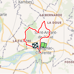
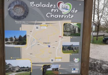
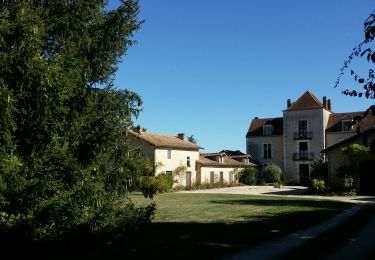
Randonnée Marche de 10,6 km à découvrir à Nouvelle-Aquitaine, Charente, Montignac-Charente. Cette randonnée est proposée par alainjoseph6.
Description
C'est une agréable rando entre la vallée de la Charente et Saint Amand de Boixe en parcourant de magnifiques chemins avec de nombreux points de vue.
Localisation
Pays :
France
Région :
Nouvelle-Aquitaine
Département/Province :
Charente
Commune :
Montignac-Charente
Localité :
Unknown
Départ:(Dec)
Départ:(UTM)
276366 ; 5074147 (31T) N.
Commentaires
Randonnées à proximité
![Randonnée Marche Villejoubert - Villejoubert et le château de la Barre - Photo](https://media.geolcdn.com/t/375/260/907ad314-aab5-49d2-9367-f56fc4587c7a.jpg&format=jpg&maxdim=2)
![Marche Marche](https://static1.geolcdn.com/sitytour/trail-icons/101.png)
Villejoubert et le château de la Barre
Marche
Moyen
Villejoubert,
Nouvelle-Aquitaine,
Charente,
France
![](/images/other/stat-length.png)
7,4 km | 8,6 km-effort
2h 17min
![](https://static1.geolcdn.com/siteimages/upload/files/16400158638029165_repeat_loop_refresh_sync_direction_icon.png)
Oui
![Randonnée Marche Vouharte - Les hauts de VOUHARTE Charente - Photo](https://media.geolcdn.com/t/375/260/3c61a0db-af5d-42e2-9149-a0b6d1b08d1f.jpg&format=jpg&maxdim=2)
![Marche Marche](https://static1.geolcdn.com/sitytour/trail-icons/101.png)
Les hauts de VOUHARTE Charente
Marche
Moyen
Vouharte,
Nouvelle-Aquitaine,
Charente,
France
![](/images/other/stat-length.png)
7,6 km | 9,1 km-effort
2h 56min
![](https://static1.geolcdn.com/siteimages/upload/files/16400158638029165_repeat_loop_refresh_sync_direction_icon.png)
Oui
![Randonnée Marche Villejoubert - De Villejoubert à la Macarine - Photo](https://media.geolcdn.com/t/375/260/492a0f69-240e-440b-ad62-3e34775d9d25.jpg&format=jpg&maxdim=2)
![Marche Marche](https://static1.geolcdn.com/sitytour/trail-icons/101.png)
De Villejoubert à la Macarine
Marche
Facile
Villejoubert,
Nouvelle-Aquitaine,
Charente,
France
![](/images/other/stat-length.png)
4,9 km | 5,7 km-effort
1h 51min
![](https://static1.geolcdn.com/siteimages/upload/files/16400158638029165_repeat_loop_refresh_sync_direction_icon.png)
Oui
![Randonnée Marche Villejoubert - La randonnée de La Macarine - Photo](https://media.geolcdn.com/t/375/260/db059127-d362-4189-afda-718da456fa14.jpg&format=jpg&maxdim=2)
![Marche Marche](https://static1.geolcdn.com/sitytour/trail-icons/101.png)
La randonnée de La Macarine
Marche
Facile
(1)
Villejoubert,
Nouvelle-Aquitaine,
Charente,
France
![](/images/other/stat-length.png)
10,8 km | 12,2 km-effort
3h 12min
![](https://static1.geolcdn.com/siteimages/upload/files/16400158638029165_repeat_loop_refresh_sync_direction_icon.png)
Oui
![Randonnée Course à pied Marsac - 2023-10-15 Marsac (Charente) - Photo](https://media.geolcdn.com/t/375/260/ext.jpg?maxdim=2&url=https%3A%2F%2Fstatic1.geolcdn.com%2Fsiteimages%2Fupload%2Ffiles%2F1524743154running.jpg)
![Course à pied Course à pied](https://static1.geolcdn.com/sitytour/trail-icons/103.png)
2023-10-15 Marsac (Charente)
Course à pied
Facile
Marsac,
Nouvelle-Aquitaine,
Charente,
France
![](/images/other/stat-length.png)
10 km | 12,4 km-effort
1h 4min
![](https://static1.geolcdn.com/siteimages/upload/files/16400158638029165_repeat_loop_refresh_sync_direction_icon.png)
Oui
![Randonnée Marche Marsac - marsac - Photo](https://media.geolcdn.com/t/375/260/ext.jpg?maxdim=2&url=https%3A%2F%2Fstatic1.geolcdn.com%2Fsiteimages%2Fupload%2Ffiles%2F1553511878bg_sport_marche.png)
![Marche Marche](https://static1.geolcdn.com/sitytour/trail-icons/101.png)
marsac
Marche
Très facile
Marsac,
Nouvelle-Aquitaine,
Charente,
France
![](/images/other/stat-length.png)
9,4 km | 11,5 km-effort
2h 28min
![](https://static1.geolcdn.com/siteimages/upload/files/16400158638029165_repeat_loop_refresh_sync_direction_icon.png)
Non
![Randonnée Marche Marsac - Marsac180220 - Photo](https://media.geolcdn.com/t/375/260/ext.jpg?maxdim=2&url=https%3A%2F%2Fstatic1.geolcdn.com%2Fsiteimages%2Fupload%2Ffiles%2F1553511878bg_sport_marche.png)
![Marche Marche](https://static1.geolcdn.com/sitytour/trail-icons/101.png)
Marsac180220
Marche
Très facile
Marsac,
Nouvelle-Aquitaine,
Charente,
France
![](/images/other/stat-length.png)
11,8 km | 15,5 km-effort
3h 7min
![](https://static1.geolcdn.com/siteimages/upload/files/16400158638029165_repeat_loop_refresh_sync_direction_icon.png)
Oui
![Randonnée Marche Vars - vars190120 - Photo](https://media.geolcdn.com/t/375/260/ext.jpg?maxdim=2&url=https%3A%2F%2Fstatic1.geolcdn.com%2Fsiteimages%2Fupload%2Ffiles%2F1553511878bg_sport_marche.png)
![Marche Marche](https://static1.geolcdn.com/sitytour/trail-icons/101.png)
vars190120
Marche
Très facile
Vars,
Nouvelle-Aquitaine,
Charente,
France
![](/images/other/stat-length.png)
10,8 km | 13 km-effort
2h 44min
![](https://static1.geolcdn.com/siteimages/upload/files/16400158638029165_repeat_loop_refresh_sync_direction_icon.png)
Oui
![Randonnée Marche Vouharte - vouharte1012 - Photo](https://media.geolcdn.com/t/375/260/ext.jpg?maxdim=2&url=https%3A%2F%2Fstatic1.geolcdn.com%2Fsiteimages%2Fupload%2Ffiles%2F1553511878bg_sport_marche.png)
![Marche Marche](https://static1.geolcdn.com/sitytour/trail-icons/101.png)
vouharte1012
Marche
Très facile
Vouharte,
Nouvelle-Aquitaine,
Charente,
France
![](/images/other/stat-length.png)
11,3 km | 13,5 km-effort
2h 44min
![](https://static1.geolcdn.com/siteimages/upload/files/16400158638029165_repeat_loop_refresh_sync_direction_icon.png)
Oui