![](/images/other/stat-length.png)
![Randonnée Marche Courpalay - Randonnées des lavoirs Courpalay - Photo](https://media.geolcdn.com/t/1900/400/ext.pjpeg?maxdim=2&url=https%3A%2F%2Fstatic1.geolcdn.com%2Fsiteimages%2Fupload%2Ffiles%2F1553511878bg_sport_marche.png)
Randonnées des lavoirs Courpalay
pikibangi
Utilisateur
![Longueur](/images/other/stat-length.png)
Longueur
23 km
![Altitude max](https://static1.geolcdn.com/siteimages/upload/files/1508320355ic_sort_altitude_max_24dp.png)
Altitude max
113 m
![Dénivelé positif](https://static1.geolcdn.com/siteimages/upload/files/1508320355ic_sort_den_pos_24dp.png)
Dénivelé positif
194 m
![Km-Effort](/images/other/stat-length.png)
Km-Effort
25 km
![Altitude min](https://static1.geolcdn.com/siteimages/upload/files/1508320355ic_sort_altitude_min_24dp.png)
Altitude min
78 m
![Dénivelé négatif](https://static1.geolcdn.com/siteimages/upload/files/1508320355ic_sort_den_neg_24dp.png)
Dénivelé négatif
194 m
![Boucle](https://static1.geolcdn.com/siteimages/upload/files/16400158638029165_repeat_loop_refresh_sync_direction_icon.png)
Boucle
Oui
Date de création :
2019-05-01 06:47:12.331
Dernière modification :
2019-05-01 16:59:50.07
![Marche](https://static1.geolcdn.com/sitytour/trail-icons/101.png)
6h32
Difficulté : Très facile
![Scannez ce code QR pour ouvrir la randonnée dans l'application SityTrail](https://capi.geolives.com/qq0zvz2zws4bq2lad0pu/sitytour/trails/2070208/qr.png?size=200)
Application GPS de randonnée GRATUITE
À propos
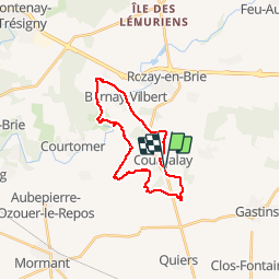
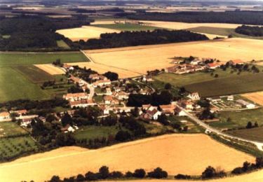
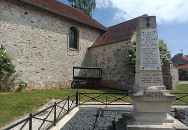
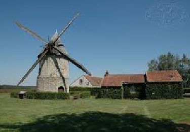
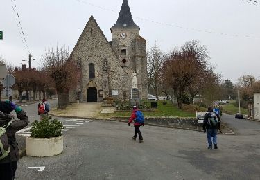
Randonnée Marche de 23 km à découvrir à Île-de-France, Seine-et-Marne, Courpalay. Cette randonnée est proposée par pikibangi.
Description
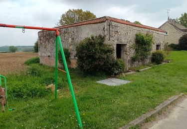
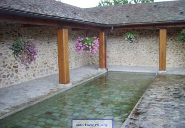
Randonnées des lavoirs au départ de Courpalay. Édition 1er mai 2019.
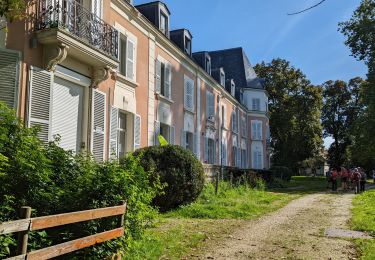
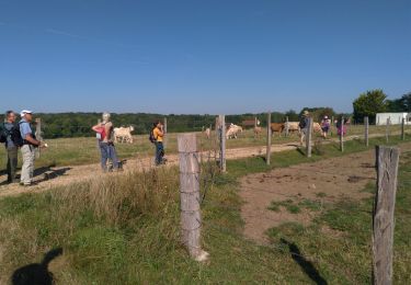
Randonnée agréable avec une belle journée ensoleillée et l'arrivée avec la bière locale, pour redonner des forces après l'effort.
Localisation
Pays :
France
Région :
Île-de-France
Département/Province :
Seine-et-Marne
Commune :
Courpalay
Localité :
Unknown
Départ:(Dec)
Départ:(UTM)
497226 ; 5388156 (31U) N.
Commentaires
Randonnées à proximité
![Randonnée Marche Courtomer - Boucle Courtomer - chaumes en Brie - - Photo](https://media.geolcdn.com/t/375/260/4c724cf3-58fd-4de3-a054-aacb416cef6c.jpg&format=jpg&maxdim=2)
![Marche Marche](https://static1.geolcdn.com/sitytour/trail-icons/101.png)
Boucle Courtomer - chaumes en Brie -
Marche
Facile
Courtomer,
Île-de-France,
Seine-et-Marne,
France
![](/images/other/stat-length.png)
20 km | 23 km-effort
4h 34min
![](https://static1.geolcdn.com/siteimages/upload/files/16400158638029165_repeat_loop_refresh_sync_direction_icon.png)
Oui
![Randonnée Marche Bernay-Vilbert - Boucle de Bernay - Photo](https://media.geolcdn.com/t/375/260/0badd9bc-4790-4ce2-8ad5-41233d0a2e71.jpg&format=jpg&maxdim=2)
![Marche Marche](https://static1.geolcdn.com/sitytour/trail-icons/101.png)
Boucle de Bernay
Marche
Moyen
Bernay-Vilbert,
Île-de-France,
Seine-et-Marne,
France
![](/images/other/stat-length.png)
7,9 km | 9 km-effort
2h 6min
![](https://static1.geolcdn.com/siteimages/upload/files/16400158638029165_repeat_loop_refresh_sync_direction_icon.png)
Oui
![Randonnée Marche La Chapelle-Iger - Les côteaux Capelligérois - La Chapelle-Iger - Photo](https://media.geolcdn.com/t/375/260/ext.jpg?maxdim=2&url=https%3A%2F%2Fservices.sitytrail.com%2FGeolivesWS%2FDownloadMedia.ashx%3FTrailID%3D111434%26Media%3D7247_3.jpg)
![Marche Marche](https://static1.geolcdn.com/sitytour/trail-icons/101.png)
Les côteaux Capelligérois - La Chapelle-Iger
Marche
Difficile
La Chapelle-Iger,
Île-de-France,
Seine-et-Marne,
France
![](/images/other/stat-length.png)
13,5 km | 15,3 km-effort
3h 19min
![](https://static1.geolcdn.com/siteimages/upload/files/16400158638029165_repeat_loop_refresh_sync_direction_icon.png)
Oui
![Randonnée Marche Courpalay - courpalay - Photo](https://media.geolcdn.com/t/375/260/ext.jpg?maxdim=2&url=https%3A%2F%2Fstatic1.geolcdn.com%2Fsiteimages%2Fupload%2Ffiles%2F1553511878bg_sport_marche.png)
![Marche Marche](https://static1.geolcdn.com/sitytour/trail-icons/101.png)
courpalay
Marche
Facile
(1)
Courpalay,
Île-de-France,
Seine-et-Marne,
France
![](/images/other/stat-length.png)
13,7 km | 15,3 km-effort
3h 20min
![](https://static1.geolcdn.com/siteimages/upload/files/16400158638029165_repeat_loop_refresh_sync_direction_icon.png)
Oui
![Randonnée Marche Courpalay - Courpalay - Photo](https://media.geolcdn.com/t/375/260/8b75a87c-9af5-4c3b-a34c-55caf118b693.jpg&format=jpg&maxdim=2)
![Marche Marche](https://static1.geolcdn.com/sitytour/trail-icons/101.png)
Courpalay
Marche
Moyen
Courpalay,
Île-de-France,
Seine-et-Marne,
France
![](/images/other/stat-length.png)
8,6 km | 9,8 km-effort
2h 39min
![](https://static1.geolcdn.com/siteimages/upload/files/16400158638029165_repeat_loop_refresh_sync_direction_icon.png)
Oui
![Randonnée Marche Courpalay - JC 93 - Randonnées des lavoirs - 19 km - Photo](https://media.geolcdn.com/t/375/260/fa54443c-4720-4cee-9756-9184d788307c.jpg&format=jpg&maxdim=2)
![Marche Marche](https://static1.geolcdn.com/sitytour/trail-icons/101.png)
JC 93 - Randonnées des lavoirs - 19 km
Marche
Difficile
Courpalay,
Île-de-France,
Seine-et-Marne,
France
![](/images/other/stat-length.png)
19,2 km | 22 km-effort
4h 58min
![](https://static1.geolcdn.com/siteimages/upload/files/16400158638029165_repeat_loop_refresh_sync_direction_icon.png)
Oui
![Randonnée Marche La Chapelle-Iger - Chapelle Iger - Photo](https://media.geolcdn.com/t/375/260/94ccf62d-3c42-4d7c-83a6-5d59eec3bc13.jpg&format=jpg&maxdim=2)
![Marche Marche](https://static1.geolcdn.com/sitytour/trail-icons/101.png)
Chapelle Iger
Marche
Moyen
La Chapelle-Iger,
Île-de-France,
Seine-et-Marne,
France
![](/images/other/stat-length.png)
10,2 km | 11,4 km-effort
2h 3min
![](https://static1.geolcdn.com/siteimages/upload/files/16400158638029165_repeat_loop_refresh_sync_direction_icon.png)
Oui
![Randonnée Marche La Chapelle-Iger - JC 05 19 km la Chapelle Iger - Photo](https://media.geolcdn.com/t/375/260/a5724690-204d-473f-ab68-a5fbec7ba8ce.jpg&format=jpg&maxdim=2)
![Marche Marche](https://static1.geolcdn.com/sitytour/trail-icons/101.png)
JC 05 19 km la Chapelle Iger
Marche
Difficile
La Chapelle-Iger,
Île-de-France,
Seine-et-Marne,
France
![](/images/other/stat-length.png)
18,8 km | 21 km-effort
4h 18min
![](https://static1.geolcdn.com/siteimages/upload/files/16400158638029165_repeat_loop_refresh_sync_direction_icon.png)
Oui
![Randonnée Autre activité Courpalay - courpalay - Photo](https://media.geolcdn.com/t/375/260/ext.jpg?maxdim=2&url=https%3A%2F%2Fservices.sitytrail.com%2FGeolivesWS%2FDownloadMedia.ashx%3FTrailID%3D689301%26Media%3Dfix__20170125141357.jpg)
![Autre activité Autre activité](https://static1.geolcdn.com/sitytour/trail-icons/900.png)
courpalay
Autre activité
Très facile
Courpalay,
Île-de-France,
Seine-et-Marne,
France
![](/images/other/stat-length.png)
16,1 km | 18,3 km-effort
3h 51min
![](https://static1.geolcdn.com/siteimages/upload/files/16400158638029165_repeat_loop_refresh_sync_direction_icon.png)
Oui