![](/images/other/stat-length.png)
![Randonnée Marche Saint-Jean-d'Arvey - Tour sous le nivolet - Photo](https://media.geolcdn.com/t/1900/400/0bab91d0-7df8-4b5d-b54c-59d025e6a17f.jpg&format=pjpeg&maxdim=2)
Tour sous le nivolet
Michel_Martin
Utilisateur
![Longueur](/images/other/stat-length.png)
Longueur
12,9 km
![Altitude max](https://static1.geolcdn.com/siteimages/upload/files/1508320355ic_sort_altitude_max_24dp.png)
Altitude max
1171 m
![Dénivelé positif](https://static1.geolcdn.com/siteimages/upload/files/1508320355ic_sort_den_pos_24dp.png)
Dénivelé positif
918 m
![Km-Effort](/images/other/stat-length.png)
Km-Effort
25 km
![Altitude min](https://static1.geolcdn.com/siteimages/upload/files/1508320355ic_sort_altitude_min_24dp.png)
Altitude min
410 m
![Dénivelé négatif](https://static1.geolcdn.com/siteimages/upload/files/1508320355ic_sort_den_neg_24dp.png)
Dénivelé négatif
914 m
![Boucle](https://static1.geolcdn.com/siteimages/upload/files/16400158638029165_repeat_loop_refresh_sync_direction_icon.png)
Boucle
Oui
Date de création :
2019-04-23 06:19:45.131
Dernière modification :
2019-04-27 13:54:56.658
![Marche](https://static1.geolcdn.com/sitytour/trail-icons/101.png)
5h20
Difficulté : Facile
![Scannez ce code QR pour ouvrir la randonnée dans l'application SityTrail](https://capi.geolives.com/qq0zvz2zws4bq2lad0pu/sitytour/trails/2067553/qr.png?size=200)
Application GPS de randonnée GRATUITE
À propos
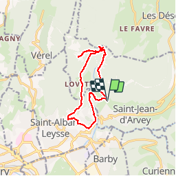
Randonnée Marche de 12,9 km à découvrir à Auvergne-Rhône-Alpes, Savoie, Saint-Jean-d'Arvey. Cette randonnée est proposée par Michel_Martin.
Description
Départ parking Chaffardon à St Jean d'Arvey. Descente à Monterminod.
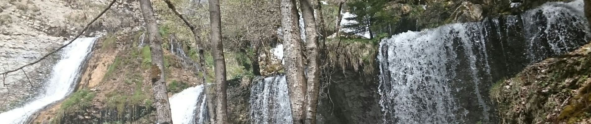
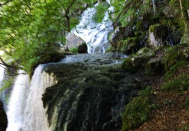
Remontée par Lovettaz. Grotte Carret . Village du Nivolet . Retour par la cascade de la Doria.
Localisation
Pays :
France
Région :
Auvergne-Rhône-Alpes
Département/Province :
Savoie
Commune :
Saint-Jean-d'Arvey
Localité :
Unknown
Départ:(Dec)
Départ:(UTM)
732608 ; 5052915 (31T) N.
Commentaires
Randonnées à proximité
![Randonnée Course à pied Saint-Jean-d'Arvey - Tour du plateau de la Leysse - Photo](https://media.geolcdn.com/t/375/260/ext.jpg?maxdim=2&url=https%3A%2F%2Fservices.sitytrail.com%2FGeolivesWS%2FDownloadMedia.ashx%3FTrailID%3D127434%26Media%3D08a8806c-d534-407b-8c02-e91e2473a9c8.JPG)
![Course à pied Course à pied](https://static1.geolcdn.com/sitytour/trail-icons/103.png)
Tour du plateau de la Leysse
Course à pied
Très facile
(1)
Saint-Jean-d'Arvey,
Auvergne-Rhône-Alpes,
Savoie,
France
![](/images/other/stat-length.png)
47 km | 82 km-effort
10h 0min
![](https://static1.geolcdn.com/siteimages/upload/files/16400158638029165_repeat_loop_refresh_sync_direction_icon.png)
Oui
![Randonnée Marche Challes-les-Eaux - Le Mont Saint-Michel 895 m, depuis Challes-les-Eaux - Photo](https://media.geolcdn.com/t/375/260/ext.jpg?maxdim=2&url=https%3A%2F%2Fservices.sitytrail.com%2FGeolivesWS%2FDownloadMedia.ashx%3FTrailID%3D191627%26Media%3D15268_1.jpg)
![Marche Marche](https://static1.geolcdn.com/sitytour/trail-icons/101.png)
Le Mont Saint-Michel 895 m, depuis Challes-les-Eaux
Marche
Difficile
(1)
Challes-les-Eaux,
Auvergne-Rhône-Alpes,
Savoie,
France
![](/images/other/stat-length.png)
7,6 km | 15 km-effort
4h 15min
![](https://static1.geolcdn.com/siteimages/upload/files/16400158638029165_repeat_loop_refresh_sync_direction_icon.png)
Oui
![Randonnée V.T.T. Bassens - Pragondra - Photo](https://media.geolcdn.com/t/375/260/ext.jpg?maxdim=2&url=https%3A%2F%2Fservices.sitytrail.com%2FGeolivesWS%2FDownloadMedia.ashx%3FTrailID%3D147927%26Media%3D20120818110710.jpg)
![V.T.T. V.T.T.](https://static1.geolcdn.com/sitytour/trail-icons/202.png)
Pragondra
V.T.T.
Très facile
(1)
Bassens,
Auvergne-Rhône-Alpes,
Savoie,
France
![](/images/other/stat-length.png)
24 km | 34 km-effort
2h 49min
![](https://static1.geolcdn.com/siteimages/upload/files/16400158638029165_repeat_loop_refresh_sync_direction_icon.png)
Non
![Randonnée Marche Thoiry - le golet de l'agneau - Photo](https://media.geolcdn.com/t/375/260/95fcbe0f-c4e5-4eb2-ad04-6bb3c6835482.jpg&format=jpg&maxdim=2)
![Marche Marche](https://static1.geolcdn.com/sitytour/trail-icons/101.png)
le golet de l'agneau
Marche
Moyen
Thoiry,
Auvergne-Rhône-Alpes,
Savoie,
France
![](/images/other/stat-length.png)
13,2 km | 26 km-effort
5h 20min
![](https://static1.geolcdn.com/siteimages/upload/files/16400158638029165_repeat_loop_refresh_sync_direction_icon.png)
Oui
![Randonnée Vélo Saint-Jean-d'Arvey - st jean meythet via plainpalais et semnoz - Photo](https://media.geolcdn.com/t/375/260/ext.jpg?maxdim=2&url=https%3A%2F%2Fstatic1.geolcdn.com%2Fsiteimages%2Fupload%2Ffiles%2F1524743154velo.jpg)
![Vélo Vélo](https://static1.geolcdn.com/sitytour/trail-icons/200.png)
st jean meythet via plainpalais et semnoz
Vélo
Difficile
(1)
Saint-Jean-d'Arvey,
Auvergne-Rhône-Alpes,
Savoie,
France
![](/images/other/stat-length.png)
66 km | 92 km-effort
3h 16min
![](https://static1.geolcdn.com/siteimages/upload/files/16400158638029165_repeat_loop_refresh_sync_direction_icon.png)
Non
![Randonnée Marche Saint-Alban-Leysse - 73- Le chemin des poussettes - Photo](https://media.geolcdn.com/t/375/260/ext.jpg?maxdim=2&url=https%3A%2F%2Fstatic1.geolcdn.com%2Fsiteimages%2Fupload%2Ffiles%2F1553511878bg_sport_marche.png)
![Marche Marche](https://static1.geolcdn.com/sitytour/trail-icons/101.png)
73- Le chemin des poussettes
Marche
Facile
(1)
Saint-Alban-Leysse,
Auvergne-Rhône-Alpes,
Savoie,
France
![](/images/other/stat-length.png)
4,9 km | 10,6 km-effort
2h 2min
![](https://static1.geolcdn.com/siteimages/upload/files/16400158638029165_repeat_loop_refresh_sync_direction_icon.png)
Oui
![Randonnée V.T.T. Saint-Alban-Leysse - 2012-03-24 - Malpassant+ St sat - Photo](https://media.geolcdn.com/t/375/260/ext.jpg?maxdim=2&url=https%3A%2F%2Fstatic1.geolcdn.com%2Fsiteimages%2Fupload%2Ffiles%2F1524743154velo.jpg)
![V.T.T. V.T.T.](https://static1.geolcdn.com/sitytour/trail-icons/202.png)
2012-03-24 - Malpassant+ St sat
V.T.T.
Moyen
(1)
Saint-Alban-Leysse,
Auvergne-Rhône-Alpes,
Savoie,
France
![](/images/other/stat-length.png)
27 km | 44 km-effort
3h 2min
![](https://static1.geolcdn.com/siteimages/upload/files/16400158638029165_repeat_loop_refresh_sync_direction_icon.png)
Oui
![Randonnée Marche Curienne - Boucle de curienne - Photo](https://media.geolcdn.com/t/375/260/bf0e46c4-b1d7-4727-95a4-0b49e6273a30.jpg&format=jpg&maxdim=2)
![Marche Marche](https://static1.geolcdn.com/sitytour/trail-icons/101.png)
Boucle de curienne
Marche
Facile
Curienne,
Auvergne-Rhône-Alpes,
Savoie,
France
![](/images/other/stat-length.png)
6,2 km | 9,1 km-effort
2h 22min
![](https://static1.geolcdn.com/siteimages/upload/files/16400158638029165_repeat_loop_refresh_sync_direction_icon.png)
Oui
![Randonnée Marche Les Déserts - Nivolet - Photo](https://media.geolcdn.com/t/375/260/048cf6ab-404d-4bce-bd74-e2c4ccef4fd8.jpg&format=jpg&maxdim=2)
![Marche Marche](https://static1.geolcdn.com/sitytour/trail-icons/101.png)
Nivolet
Marche
Moyen
Les Déserts,
Auvergne-Rhône-Alpes,
Savoie,
France
![](/images/other/stat-length.png)
8,5 km | 19 km-effort
5h 29min
![](https://static1.geolcdn.com/siteimages/upload/files/16400158638029165_repeat_loop_refresh_sync_direction_icon.png)
Oui