![](/images/other/stat-length.png)
![Randonnée Marche Oberhaslach - Oberhaslach - Photo](https://media.geolcdn.com/t/1900/400/0418020a-bed2-46fb-a8fe-37788dffba0e.jpg&format=pjpeg&maxdim=2)
Oberhaslach
oscar1
Utilisateur
![Longueur](/images/other/stat-length.png)
Longueur
13,1 km
![Altitude max](https://static1.geolcdn.com/siteimages/upload/files/1508320355ic_sort_altitude_max_24dp.png)
Altitude max
671 m
![Dénivelé positif](https://static1.geolcdn.com/siteimages/upload/files/1508320355ic_sort_den_pos_24dp.png)
Dénivelé positif
650 m
![Km-Effort](/images/other/stat-length.png)
Km-Effort
22 km
![Altitude min](https://static1.geolcdn.com/siteimages/upload/files/1508320355ic_sort_altitude_min_24dp.png)
Altitude min
304 m
![Dénivelé négatif](https://static1.geolcdn.com/siteimages/upload/files/1508320355ic_sort_den_neg_24dp.png)
Dénivelé négatif
649 m
![Boucle](https://static1.geolcdn.com/siteimages/upload/files/16400158638029165_repeat_loop_refresh_sync_direction_icon.png)
Boucle
Oui
Date de création :
2019-04-24 08:39:41.809
Dernière modification :
2019-04-26 21:31:47.231
![Marche](https://static1.geolcdn.com/sitytour/trail-icons/101.png)
4h08
Difficulté : Moyen
![Scannez ce code QR pour ouvrir la randonnée dans l'application SityTrail](https://capi.geolives.com/qq0zvz2zws4bq2lad0pu/sitytour/trails/2066179/qr.png?size=200)
Application GPS de randonnée GRATUITE
À propos
Randonnée Marche de 13,1 km à découvrir à Grand Est, Bas-Rhin, Oberhaslach. Cette randonnée est proposée par oscar1.
Description
Prendre la rue des Écoles, dans le prolongement du début du parcours, et se diriger vers le parking situé non loin du départ
Localisation
Pays :
France
Région :
Grand Est
Département/Province :
Bas-Rhin
Commune :
Oberhaslach
Localité :
Unknown
Départ:(Dec)
Départ:(UTM)
376591 ; 5379116 (32U) N.
Commentaires
Randonnées à proximité
![Randonnée Marche Urmatt - Cascade Soultzbach - Urmatt - Photo](https://media.geolcdn.com/t/375/260/20e7652d-0a73-4a1a-a692-b5e1164e2be3.jpg&format=jpg&maxdim=2)
![Marche Marche](https://static1.geolcdn.com/sitytour/trail-icons/101.png)
Cascade Soultzbach - Urmatt
Marche
Très difficile
(1)
Urmatt,
Grand Est,
Bas-Rhin,
France
![](/images/other/stat-length.png)
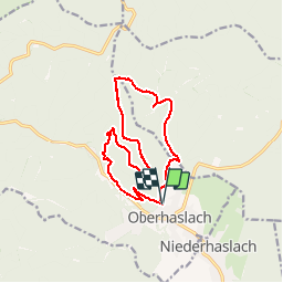
14,9 km | 21 km-effort
4h 46min
![](https://static1.geolcdn.com/siteimages/upload/files/16400158638029165_repeat_loop_refresh_sync_direction_icon.png)
Oui
![Randonnée Randonnée équestre Oberhaslach - Neufeld Boucle Elmersforst - Photo](https://media.geolcdn.com/t/375/260/ext.jpg?maxdim=2&url=https%3A%2F%2Fstatic1.geolcdn.com%2Fsiteimages%2Fupload%2Ffiles%2F1524743154cheval.jpg)
![Randonnée équestre Randonnée équestre](https://static1.geolcdn.com/sitytour/trail-icons/301.png)
Neufeld Boucle Elmersforst
Randonnée équestre
Difficile
(1)
Oberhaslach,
Grand Est,
Bas-Rhin,
France
![](/images/other/stat-length.png)
31 km | 42 km-effort
5h 9min
![](https://static1.geolcdn.com/siteimages/upload/files/16400158638029165_repeat_loop_refresh_sync_direction_icon.png)
Oui
![Randonnée Marche Lutzelhouse - 2013-05-10 Marche Rocher de Mutzig par Nideck - Photo](https://media.geolcdn.com/t/375/260/ext.jpg?maxdim=2&url=https%3A%2F%2Fstatic1.geolcdn.com%2Fsiteimages%2Fupload%2Ffiles%2F1553511878bg_sport_marche.png)
![Marche Marche](https://static1.geolcdn.com/sitytour/trail-icons/101.png)
2013-05-10 Marche Rocher de Mutzig par Nideck
Marche
Moyen
(1)
Lutzelhouse,
Grand Est,
Bas-Rhin,
France
![](/images/other/stat-length.png)
14,9 km | 24 km-effort
4h 10min
![](https://static1.geolcdn.com/siteimages/upload/files/16400158638029165_repeat_loop_refresh_sync_direction_icon.png)
Oui
![Randonnée V.T.T. Niederhaslach - Guirbaden - Grendelbruch - Photo](https://media.geolcdn.com/t/375/260/ext.jpg?maxdim=2&url=https%3A%2F%2Fservices.sitytrail.com%2FGeolivesWS%2FDownloadMedia.ashx%3FTrailID%3D103277%26Media%3D5231_1.jpg)
![V.T.T. V.T.T.](https://static1.geolcdn.com/sitytour/trail-icons/202.png)
Guirbaden - Grendelbruch
V.T.T.
Difficile
(1)
Niederhaslach,
Grand Est,
Bas-Rhin,
France
![](/images/other/stat-length.png)
26 km | 35 km-effort
2h 30min
![](https://static1.geolcdn.com/siteimages/upload/files/16400158638029165_repeat_loop_refresh_sync_direction_icon.png)
Non
![Randonnée V.T.T. Oberhaslach - Rando des Feuilles Mortes - Photo](https://media.geolcdn.com/t/375/260/ext.jpg?maxdim=2&url=https%3A%2F%2Fservices.sitytrail.com%2FGeolivesWS%2FDownloadMedia.ashx%3FTrailID%3D101060%26Media%3D551_1.jpg)
![V.T.T. V.T.T.](https://static1.geolcdn.com/sitytour/trail-icons/202.png)
Rando des Feuilles Mortes
V.T.T.
Moyen
(2)
Oberhaslach,
Grand Est,
Bas-Rhin,
France
![](/images/other/stat-length.png)
29 km | 41 km-effort
2h 0min
![](https://static1.geolcdn.com/siteimages/upload/files/16400158638029165_repeat_loop_refresh_sync_direction_icon.png)
Oui
![Randonnée Marche Lutzelhouse - 2024-01-28 Marche Rocher de Mutzig Porte de Pierre - Photo](https://media.geolcdn.com/t/375/260/a449e661-4c19-4b4c-bdec-0ce5cf123351.jpg&format=jpg&maxdim=2)
![Marche Marche](https://static1.geolcdn.com/sitytour/trail-icons/101.png)
2024-01-28 Marche Rocher de Mutzig Porte de Pierre
Marche
Moyen
Lutzelhouse,
Grand Est,
Bas-Rhin,
France
![](/images/other/stat-length.png)
15,3 km | 25 km-effort
5h 45min
![](https://static1.geolcdn.com/siteimages/upload/files/16400158638029165_repeat_loop_refresh_sync_direction_icon.png)
Oui
![Randonnée Randonnée équestre Niederhaslach - Toutes fugues - Photo](https://media.geolcdn.com/t/375/260/ext.jpg?maxdim=2&url=https%3A%2F%2Fstatic1.geolcdn.com%2Fsiteimages%2Fupload%2Ffiles%2F1524743154cheval.jpg)
![Randonnée équestre Randonnée équestre](https://static1.geolcdn.com/sitytour/trail-icons/301.png)
Toutes fugues
Randonnée équestre
Facile
(1)
Niederhaslach,
Grand Est,
Bas-Rhin,
France
![](/images/other/stat-length.png)
29 km | 39 km-effort
Inconnu
![](https://static1.geolcdn.com/siteimages/upload/files/16400158638029165_repeat_loop_refresh_sync_direction_icon.png)
Oui
![Randonnée Randonnée équestre Still - 2022-07-10 Picnic CVA Umwurf depuis Oberhaslach - Photo](https://media.geolcdn.com/t/375/260/345719c4-c8c7-4272-8b46-e89c45a30cba.jpg&format=jpg&maxdim=2)
![Randonnée équestre Randonnée équestre](https://static1.geolcdn.com/sitytour/trail-icons/301.png)
2022-07-10 Picnic CVA Umwurf depuis Oberhaslach
Randonnée équestre
Difficile
Still,
Grand Est,
Bas-Rhin,
France
![](/images/other/stat-length.png)
28 km | 40 km-effort
5h 53min
![](https://static1.geolcdn.com/siteimages/upload/files/16400158638029165_repeat_loop_refresh_sync_direction_icon.png)
Oui
![Randonnée Marche Lutzelhouse - 2019-11-30 Marche Rocher de Mutzig Noll - Photo](https://media.geolcdn.com/t/375/260/f1ae836b-d063-4b16-aefc-2c8e07433ca1.jpg&format=jpg&maxdim=2)
![Marche Marche](https://static1.geolcdn.com/sitytour/trail-icons/101.png)
2019-11-30 Marche Rocher de Mutzig Noll
Marche
Très facile
Lutzelhouse,
Grand Est,
Bas-Rhin,
France
![](/images/other/stat-length.png)
18,7 km | 29 km-effort
4h 39min
![](https://static1.geolcdn.com/siteimages/upload/files/16400158638029165_repeat_loop_refresh_sync_direction_icon.png)
Oui