![](/images/other/stat-length.png)
![Randonnée Marche Airole - Airole - Breil sur Roya - Photo](https://media.geolcdn.com/t/1900/400/17882b61-179f-418d-a49d-9f9db6334a2e.jpg&format=pjpeg&maxdim=2)
Airole - Breil sur Roya
ETMU5496
Utilisateur
![Longueur](/images/other/stat-length.png)
Longueur
18 km
![Boucle](https://static1.geolcdn.com/siteimages/upload/files/16400158638029165_repeat_loop_refresh_sync_direction_icon.png)
Boucle
Non
Date de création :
2019-04-17 07:00:16.0
Dernière modification :
2019-04-24 16:43:56.257
![Marche](https://static1.geolcdn.com/sitytour/trail-icons/101.png)
6h26
Difficulté : Difficile
![Scannez ce code QR pour ouvrir la randonnée dans l'application SityTrail](https://capi.geolives.com/qq0zvz2zws4bq2lad0pu/sitytour/trails/2062979/qr.png?size=200)
Application GPS de randonnée GRATUITE
À propos
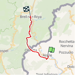
Randonnée Marche de 18 km à découvrir à Ligurie, Imperia, Airole. Cette randonnée est proposée par ETMU5496.
Description
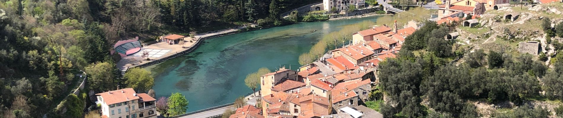
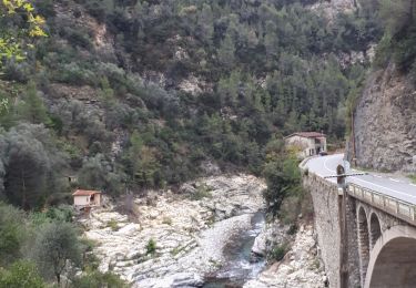
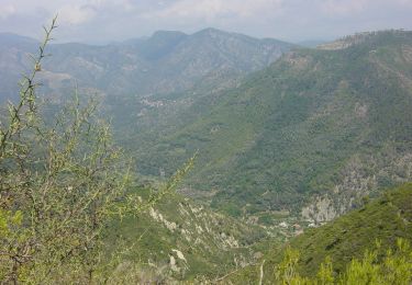
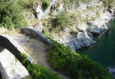
Beau circuit dans la vallée de la Roya au départ de Airole.
Quelques exigences au travers les 18 km de tracé et les 1036 m positif vs 855 m négatif.
Localisation
Pays :
Italie
Région :
Ligurie
Département/Province :
Imperia
Commune :
Airole
Localité :
Unknown
Départ:(Dec)
Départ:(UTM)
383836 ; 4858368 (32T) N.
Commentaires
Randonnées à proximité
![Randonnée A pied Airole - Traversée Airole-Breil - Photo](https://media.geolcdn.com/t/375/260/62b54dcb-d617-407a-81a2-9f5c93e8261f.jpeg&format=jpg&maxdim=2)
![A pied A pied](https://static1.geolcdn.com/sitytour/trail-icons/100.png)
Traversée Airole-Breil
A pied
Moyen
Airole,
Ligurie,
Imperia,
Italie
![](/images/other/stat-length.png)
12,7 km | 20 km-effort
4h 33min
![](https://static1.geolcdn.com/siteimages/upload/files/16400158638029165_repeat_loop_refresh_sync_direction_icon.png)
Non
![Randonnée A pied Breil-sur-Roya - Circuit de Libre - Photo](https://media.geolcdn.com/t/375/260/dcdab34e-1af6-4915-900a-fc3842fda859.jpeg&format=jpg&maxdim=2)
![A pied A pied](https://static1.geolcdn.com/sitytour/trail-icons/100.png)
Circuit de Libre
A pied
Facile
Breil-sur-Roya,
Provence-Alpes-Côte d'Azur,
Alpes-Maritimes,
France
![](/images/other/stat-length.png)
7 km | 14 km-effort
3h 10min
![](https://static1.geolcdn.com/siteimages/upload/files/16400158638029165_repeat_loop_refresh_sync_direction_icon.png)
Oui
![Randonnée A pied Breil-sur-Roya - Hameau de Piène Haute - Photo](https://media.geolcdn.com/t/375/260/ba7ed6ca-7792-48a5-80e1-bdc0636dfb80.jpeg&format=jpg&maxdim=2)
![A pied A pied](https://static1.geolcdn.com/sitytour/trail-icons/100.png)
Hameau de Piène Haute
A pied
Facile
Breil-sur-Roya,
Provence-Alpes-Côte d'Azur,
Alpes-Maritimes,
France
![](/images/other/stat-length.png)
6,1 km | 12 km-effort
2h 42min
![](https://static1.geolcdn.com/siteimages/upload/files/16400158638029165_repeat_loop_refresh_sync_direction_icon.png)
Oui
![Randonnée A pied Vintimille - AM0 - ALPI MARE 0 - Photo](https://media.geolcdn.com/t/375/260/6cc1eb13-113d-4d04-9dbb-12c9f2aaa749.jpeg&format=jpg&maxdim=2)
![A pied A pied](https://static1.geolcdn.com/sitytour/trail-icons/100.png)
AM0 - ALPI MARE 0
A pied
Facile
Vintimille,
Ligurie,
Imperia,
Italie
![](/images/other/stat-length.png)
9,7 km | 13,8 km-effort
3h 8min
![](https://static1.geolcdn.com/siteimages/upload/files/16400158638029165_repeat_loop_refresh_sync_direction_icon.png)
Non
![Randonnée Marche Breil-sur-Roya - Circuit Libre , Breil sur Roya - Photo](https://media.geolcdn.com/t/375/260/ceb351f5-9102-48c3-81fd-8ae3bb85ee14.jpg&format=jpg&maxdim=2)
![Marche Marche](https://static1.geolcdn.com/sitytour/trail-icons/101.png)
Circuit Libre , Breil sur Roya
Marche
Moyen
Breil-sur-Roya,
Provence-Alpes-Côte d'Azur,
Alpes-Maritimes,
France
![](/images/other/stat-length.png)
10,6 km | 21 km-effort
4h 5min
![](https://static1.geolcdn.com/siteimages/upload/files/16400158638029165_repeat_loop_refresh_sync_direction_icon.png)
Oui
![Randonnée A pied Airole - Anello del Gramondo - Photo](https://media.geolcdn.com/t/375/260/a83852fd-a46b-4921-bf67-5c05a5b0232d.jpeg&format=jpg&maxdim=2)
![A pied A pied](https://static1.geolcdn.com/sitytour/trail-icons/100.png)
Anello del Gramondo
A pied
Facile
Airole,
Ligurie,
Imperia,
Italie
![](/images/other/stat-length.png)
5 km | 7,9 km-effort
1h 47min
![](https://static1.geolcdn.com/siteimages/upload/files/16400158638029165_repeat_loop_refresh_sync_direction_icon.png)
Non
![Randonnée A pied Airole - Anello del Gramondo - Photo](https://media.geolcdn.com/t/375/260/9fe7e0b5-8198-4662-8b3c-f48a75f07d69.jpeg&format=jpg&maxdim=2)
![A pied A pied](https://static1.geolcdn.com/sitytour/trail-icons/100.png)
Anello del Gramondo
A pied
Difficile
Airole,
Ligurie,
Imperia,
Italie
![](/images/other/stat-length.png)
22 km | 40 km-effort
8h 59min
![](https://static1.geolcdn.com/siteimages/upload/files/16400158638029165_repeat_loop_refresh_sync_direction_icon.png)
Non
![Randonnée A pied Airole - Anello del Colombin - Photo](https://media.geolcdn.com/t/375/260/16914238-78f2-4214-b920-a884aa69e150.jpeg&format=jpg&maxdim=2)
![A pied A pied](https://static1.geolcdn.com/sitytour/trail-icons/100.png)
Anello del Colombin
A pied
Facile
Airole,
Ligurie,
Imperia,
Italie
![](/images/other/stat-length.png)
6,4 km | 9,8 km-effort
2h 13min
![](https://static1.geolcdn.com/siteimages/upload/files/16400158638029165_repeat_loop_refresh_sync_direction_icon.png)
Non
![Randonnée A pied Rocchetta Nervina - Rocchetta Nervina - Fontana Povera - Photo](https://media.geolcdn.com/t/375/260/08f7f251-bcba-4dd2-a02f-5b0d0bce6104.jpeg&format=jpg&maxdim=2)
![A pied A pied](https://static1.geolcdn.com/sitytour/trail-icons/100.png)
Rocchetta Nervina - Fontana Povera
A pied
Facile
Rocchetta Nervina,
Ligurie,
Imperia,
Italie
![](/images/other/stat-length.png)
5,6 km | 15 km-effort
3h 25min
![](https://static1.geolcdn.com/siteimages/upload/files/16400158638029165_repeat_loop_refresh_sync_direction_icon.png)
Non