Randonnée Moteur Noé - TOULOUSE NERIS - Photo
 abalcerek
abalcerek

Utilisateur

© OpenStreetMap contributors
Longueur
Longueur
489 km
Altitude max
Altitude max
1018 m
Dénivelé positif
Dénivelé positif
8250 m
Km-Effort
Km-Effort  
599 km
Altitude min
Altitude min
98 m
Dénivelé négatif
Dénivelé négatif
8108 m
Boucle
Boucle
Non
Date de création :
2014-12-10 00:00:00.0
Dernière modification :
2014-12-10 00:00:00.0

(0 Avis)

Moteur
Moteur
7h30
Difficulté : Très facile

Scannez ce code QR pour ouvrir la randonnée dans l'application SityTrail

Application GPS de randonnée GRATUITE

Logo SityTrail SityTrail

IGN / Instituts géographiques

Télécharger SityTrail sur l'App Store Télécharger SityTrail sur Google Play

Logo SityTrail SityTrail World

Le monde est à vous

Télécharger SityTrail sur l'App Store Télécharger SityTrail sur Google Play Télécharger SityTrail sur Huawei AppGallery

À propos

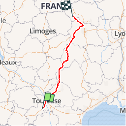
Randonnée Moteur de 489 km à découvrir à Occitanie, Haute-Garonne, Noé. Cette randonnée est proposée par abalcerek.

Profil altimétrique

Localisation

Pays :
France
Région :
Occitanie
Département/Province :
Haute-Garonne
Commune :
Noé
Localité :
Unknown
Départ:(Dec)
Départ:(UTM)
360155 ; 4801795 (31T) N.

Randonnées à proximité

Randonnée V.T.T. Longages - viagarona2 - Photo
V.T.T.
ra2000

V.T.T.

Moyen
Longages, Occitanie, Haute-Garonne, France
50 km | 59 km-effort
7h 40min
Non
Randonnée Marche Mauzac - Mauzac (la Grange) - Photo
Marche
pidjam

Marche

Facile
Mauzac, Occitanie, Haute-Garonne, France
11,1 km | 14,1 km-effort
3h 7min
Oui
Randonnée Marche Mauzac - Mauzac-St Genies - Photo
Marche
pidjam

Marche

Facile
Mauzac, Occitanie, Haute-Garonne, France
10,8 km | 14,3 km-effort
3h 20min
Oui
Randonnée Marche Le Fauga - Boucle L'Aouach Estantens - Photo
Marche
tracegps

Marche

Moyen
Le Fauga, Occitanie, Haute-Garonne, France
11,5 km | 15,9 km-effort
3h 30min
Oui
Randonnée Marche Lavernose-Lacasse - De Lavernose à Noé et retour - Photo
Marche
tracegps

Marche

Moyen
Lavernose-Lacasse, Occitanie, Haute-Garonne, France
18,6 km | 20 km-effort
5h 0min
Non
Randonnée Marche Lavernose-Lacasse - Boucle de Lavernose  - Photo
Marche
tracegps

Marche

Facile
Lavernose-Lacasse, Occitanie, Haute-Garonne, France
10,2 km | 10,9 km-effort
3h 0min
Oui
Randonnée Marche Lavernose-Lacasse - Boucle Lavernose - Photo
Marche
tracegps

Marche

Facile
Lavernose-Lacasse, Occitanie, Haute-Garonne, France
14 km | 15,1 km-effort
3h 30min
Oui
Randonnée Marche Marquefave - De Marquefave  à Lacaugne - Photo
Marche
tracegps

Marche

Moyen
(1)
Marquefave, Occitanie, Haute-Garonne, France
13,7 km | 18,2 km-effort
4h 0min
Oui
Randonnée Course à pied Lavernose-Lacasse - Lavernose Lacasse - Photo
Course à pied
tracegps

Course à pied

Difficile
Lavernose-Lacasse, Occitanie, Haute-Garonne, France
13,6 km | 14,5 km-effort
1h 30min
Oui


Fermer
Mes abonnements