![](/images/other/stat-length.png)
![Randonnée Marche Pont-à-Mousson - Le Grand Tour de Mousson - Photo](https://media.geolcdn.com/t/1900/400/ext.pjpeg?maxdim=2&url=https%3A%2F%2Fstatic1.geolcdn.com%2Fsiteimages%2Fupload%2Ffiles%2F1553511878bg_sport_marche.png)
Le Grand Tour de Mousson
joelclaudel
Utilisateur
![Longueur](/images/other/stat-length.png)
Longueur
17,1 km
![Altitude max](https://static1.geolcdn.com/siteimages/upload/files/1508320355ic_sort_altitude_max_24dp.png)
Altitude max
378 m
![Dénivelé positif](https://static1.geolcdn.com/siteimages/upload/files/1508320355ic_sort_den_pos_24dp.png)
Dénivelé positif
315 m
![Km-Effort](/images/other/stat-length.png)
Km-Effort
21 km
![Altitude min](https://static1.geolcdn.com/siteimages/upload/files/1508320355ic_sort_altitude_min_24dp.png)
Altitude min
175 m
![Dénivelé négatif](https://static1.geolcdn.com/siteimages/upload/files/1508320355ic_sort_den_neg_24dp.png)
Dénivelé négatif
315 m
![Boucle](https://static1.geolcdn.com/siteimages/upload/files/16400158638029165_repeat_loop_refresh_sync_direction_icon.png)
Boucle
Oui
Date de création :
2014-12-10 00:00:00.0
Dernière modification :
2014-12-10 00:00:00.0
![Marche](https://static1.geolcdn.com/sitytour/trail-icons/101.png)
5h00
Difficulté : Moyen
![Scannez ce code QR pour ouvrir la randonnée dans l'application SityTrail](https://capi.geolives.com/qq0zvz2zws4bq2lad0pu/sitytour/trails/206031/qr.png?size=200)
Application GPS de randonnée GRATUITE
À propos
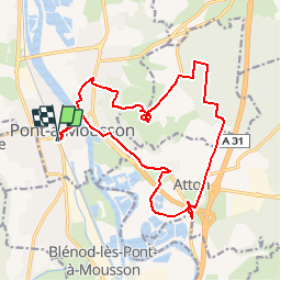
Randonnée Marche de 17,1 km à découvrir à Grand Est, Meurthe-et-Moselle, Pont-à-Mousson. Cette randonnée est proposée par joelclaudel.
Description
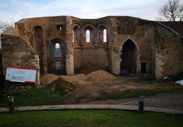
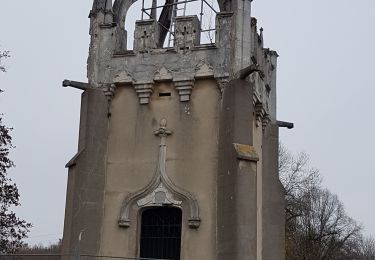
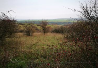
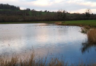
Départ de la gare de Pont à Mousson, l'Abbaye des Prémontrés, la Fontaine rouge, la butte Mousson (château), Forêt de Facq et Juré, Atton, étangs Pré des Marteaux (passage inondable par temps de pluie), Atton et retour à Pont à Mousson.
Localisation
Pays :
France
Région :
Grand Est
Département/Province :
Meurthe-et-Moselle
Commune :
Pont-à-Mousson
Localité :
Unknown
Départ:(Dec)
Départ:(UTM)
283816 ; 5420537 (32U) N.
Commentaires
Randonnées à proximité
![Randonnée V.T.T. Pont-à-Mousson - Pose balises V3 - Photo](https://media.geolcdn.com/t/375/260/ext.jpg?maxdim=2&url=https%3A%2F%2Fstatic1.geolcdn.com%2Fsiteimages%2Fupload%2Ffiles%2F1524743154velo.jpg)
![V.T.T. V.T.T.](https://static1.geolcdn.com/sitytour/trail-icons/202.png)
Pose balises V3
V.T.T.
Moyen
(1)
Pont-à-Mousson,
Grand Est,
Meurthe-et-Moselle,
France
![](/images/other/stat-length.png)
19,9 km | 26 km-effort
2h 1min
![](https://static1.geolcdn.com/siteimages/upload/files/16400158638029165_repeat_loop_refresh_sync_direction_icon.png)
Non
![Randonnée Vélo Blénod-lès-Pont-à-Mousson - blenod arnaville xonville gorce blenod - Photo](https://media.geolcdn.com/t/375/260/ext.jpg?maxdim=2&url=https%3A%2F%2Fstatic1.geolcdn.com%2Fsiteimages%2Fupload%2Ffiles%2F1524743154velo.jpg)
![Vélo Vélo](https://static1.geolcdn.com/sitytour/trail-icons/200.png)
blenod arnaville xonville gorce blenod
Vélo
Très facile
(1)
Blénod-lès-Pont-à-Mousson,
Grand Est,
Meurthe-et-Moselle,
France
![](/images/other/stat-length.png)
85 km | 93 km-effort
Inconnu
![](https://static1.geolcdn.com/siteimages/upload/files/16400158638029165_repeat_loop_refresh_sync_direction_icon.png)
Oui
![Randonnée Vélo de route Blénod-lès-Pont-à-Mousson - ST JULIEN GORCE NOVEANT - Photo](https://media.geolcdn.com/t/375/260/ext.jpg?maxdim=2&url=https%3A%2F%2Fstatic1.geolcdn.com%2Fsiteimages%2Fupload%2Ffiles%2F1524743154velo.jpg)
![Vélo de route Vélo de route](https://static1.geolcdn.com/sitytour/trail-icons/201.png)
ST JULIEN GORCE NOVEANT
Vélo de route
Très difficile
(1)
Blénod-lès-Pont-à-Mousson,
Grand Est,
Meurthe-et-Moselle,
France
![](/images/other/stat-length.png)
89 km | 97 km-effort
5h 54min
![](https://static1.geolcdn.com/siteimages/upload/files/16400158638029165_repeat_loop_refresh_sync_direction_icon.png)
Oui
![Randonnée V.T.T. Pont-à-Mousson - essai 4 LEVO SL - Photo](https://media.geolcdn.com/t/375/260/1b697b40-eb3d-4f3b-a0f5-9841bd4ac5cb.jpg&format=jpg&maxdim=2)
![V.T.T. V.T.T.](https://static1.geolcdn.com/sitytour/trail-icons/202.png)
essai 4 LEVO SL
V.T.T.
Difficile
Pont-à-Mousson,
Grand Est,
Meurthe-et-Moselle,
France
![](/images/other/stat-length.png)
58 km | 77 km-effort
3h 29min
![](https://static1.geolcdn.com/siteimages/upload/files/16400158638029165_repeat_loop_refresh_sync_direction_icon.png)
Oui
![Randonnée Marche Loisy - LES HAUTEURS DE LOISY - Le Grand Couronné - Photo](https://media.geolcdn.com/t/375/260/84e6ed9f-4df9-4427-8394-ed16ead909c1.jpg&format=jpg&maxdim=2)
![Marche Marche](https://static1.geolcdn.com/sitytour/trail-icons/101.png)
LES HAUTEURS DE LOISY - Le Grand Couronné
Marche
Facile
Loisy,
Grand Est,
Meurthe-et-Moselle,
France
![](/images/other/stat-length.png)
10,5 km | 14,2 km-effort
2h 42min
![](https://static1.geolcdn.com/siteimages/upload/files/16400158638029165_repeat_loop_refresh_sync_direction_icon.png)
Oui
![Randonnée Marche Pont-à-Mousson - Mousson par les remparts - Photo](https://media.geolcdn.com/t/375/260/876227b4-e8e9-479d-b39a-c6acedbd043a.jpg&format=jpg&maxdim=2)
![Marche Marche](https://static1.geolcdn.com/sitytour/trail-icons/101.png)
Mousson par les remparts
Marche
Très facile
Pont-à-Mousson,
Grand Est,
Meurthe-et-Moselle,
France
![](/images/other/stat-length.png)
4,6 km | 6,8 km-effort
23min
![](https://static1.geolcdn.com/siteimages/upload/files/16400158638029165_repeat_loop_refresh_sync_direction_icon.png)
Non
![Randonnée Marche Jezainville - NOTRE DAME DES AIRS - Photo](https://media.geolcdn.com/t/375/260/24f7b021-d058-487b-be2f-20686a96cb67.jpg&format=jpg&maxdim=2)
![Marche Marche](https://static1.geolcdn.com/sitytour/trail-icons/101.png)
NOTRE DAME DES AIRS
Marche
Facile
Jezainville,
Grand Est,
Meurthe-et-Moselle,
France
![](/images/other/stat-length.png)
10,7 km | 13,3 km-effort
2h 36min
![](https://static1.geolcdn.com/siteimages/upload/files/16400158638029165_repeat_loop_refresh_sync_direction_icon.png)
Oui
![Randonnée Marche Jezainville - Blénod - Jezainville - Dieulouard - Notre Dame des Airs - Photo](https://media.geolcdn.com/t/375/260/a9ef118f-84d7-474c-bdf4-7e817eab32f9.jpg&format=jpg&maxdim=2)
![Marche Marche](https://static1.geolcdn.com/sitytour/trail-icons/101.png)
Blénod - Jezainville - Dieulouard - Notre Dame des Airs
Marche
Facile
Jezainville,
Grand Est,
Meurthe-et-Moselle,
France
![](/images/other/stat-length.png)
10,7 km | 13,3 km-effort
2h 25min
![](https://static1.geolcdn.com/siteimages/upload/files/16400158638029165_repeat_loop_refresh_sync_direction_icon.png)
Oui
![Randonnée Marche Pont-à-Mousson - les etangs Muller - Photo](https://media.geolcdn.com/t/375/260/90f8f117-cc03-4c2d-bc8d-72f663a16293.jpg&format=jpg&maxdim=2)
![Marche Marche](https://static1.geolcdn.com/sitytour/trail-icons/101.png)
les etangs Muller
Marche
Très facile
Pont-à-Mousson,
Grand Est,
Meurthe-et-Moselle,
France
![](/images/other/stat-length.png)
4,4 km | 4,8 km-effort
55min
![](https://static1.geolcdn.com/siteimages/upload/files/16400158638029165_repeat_loop_refresh_sync_direction_icon.png)
Oui