![](/images/other/stat-length.png)
![Randonnée Marche nordique Paimpol - Autour de Boulgueff - Photo](https://media.geolcdn.com/t/1900/400/ext.pjpeg?maxdim=2&url=https%3A%2F%2Fstatic1.geolcdn.com%2Fsiteimages%2Fupload%2Ffiles%2F1545311037marcheuse_200dpi.jpg)
Autour de Boulgueff
alr22
Utilisateur
![Longueur](/images/other/stat-length.png)
Longueur
6,2 km
![Altitude max](https://static1.geolcdn.com/siteimages/upload/files/1508320355ic_sort_altitude_max_24dp.png)
Altitude max
75 m
![Dénivelé positif](https://static1.geolcdn.com/siteimages/upload/files/1508320355ic_sort_den_pos_24dp.png)
Dénivelé positif
148 m
![Km-Effort](/images/other/stat-length.png)
Km-Effort
8,2 km
![Altitude min](https://static1.geolcdn.com/siteimages/upload/files/1508320355ic_sort_altitude_min_24dp.png)
Altitude min
10 m
![Dénivelé négatif](https://static1.geolcdn.com/siteimages/upload/files/1508320355ic_sort_den_neg_24dp.png)
Dénivelé négatif
148 m
![Boucle](https://static1.geolcdn.com/siteimages/upload/files/16400158638029165_repeat_loop_refresh_sync_direction_icon.png)
Boucle
Oui
Date de création :
2014-12-10 00:00:00.0
Dernière modification :
2014-12-10 00:00:00.0
![Marche nordique](https://static1.geolcdn.com/sitytour/trail-icons/102.png)
1h03
Difficulté : Moyen
![Scannez ce code QR pour ouvrir la randonnée dans l'application SityTrail](https://capi.geolives.com/qq0zvz2zws4bq2lad0pu/sitytour/trails/205986/qr.png?size=200)
Application GPS de randonnée GRATUITE
À propos
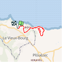
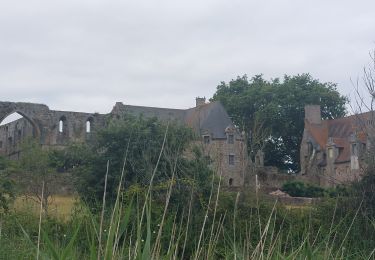
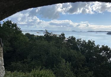
Randonnée Marche nordique de 6,2 km à découvrir à Bretagne, Côtes-d'Armor, Paimpol. Cette randonnée est proposée par alr22.
Description
Marche nordique sur 6,1km. Duree 1Heure.
Depart de Sainte-Barbe vers le Ccas de Plouezec et retour. Vue superbe sur la baie de Paimpol.
Localisation
Pays :
France
Région :
Bretagne
Département/Province :
Côtes-d'Armor
Commune :
Paimpol
Localité :
Unknown
Départ:(Dec)
Départ:(UTM)
499886 ; 5400992 (30U) N.
Commentaires
Randonnées à proximité
![Randonnée Marche Plouézec - Plouézec Port Lazo - GR34 Plage Bonaparte - 25km 560m 6h05 (50mn) - 2024 07 01 - Photo](https://media.geolcdn.com/t/375/260/1a2cc2c1-8d26-47a4-9e00-07b64e464621.jpg&format=jpg&maxdim=2)
![Marche Marche](https://static1.geolcdn.com/sitytour/trail-icons/101.png)
Plouézec Port Lazo - GR34 Plage Bonaparte - 25km 560m 6h05 (50mn) - 2024 07 01
Marche
Difficile
Plouézec,
Bretagne,
Côtes-d'Armor,
France
![](/images/other/stat-length.png)
25 km | 33 km-effort
6h 5min
![](https://static1.geolcdn.com/siteimages/upload/files/16400158638029165_repeat_loop_refresh_sync_direction_icon.png)
Oui
![Randonnée Marche Paimpol - Paimpol - GR34 Port Lazo - 25.5km 400m 6h15 (45mn) - 2024 06 30 - Photo](https://media.geolcdn.com/t/375/260/a1e8d6e5-d31d-477d-9229-268ec1b6062a.jpg&format=jpg&maxdim=2)
![Marche Marche](https://static1.geolcdn.com/sitytour/trail-icons/101.png)
Paimpol - GR34 Port Lazo - 25.5km 400m 6h15 (45mn) - 2024 06 30
Marche
Difficile
Paimpol,
Bretagne,
Côtes-d'Armor,
France
![](/images/other/stat-length.png)
26 km | 31 km-effort
6h 15min
![](https://static1.geolcdn.com/siteimages/upload/files/16400158638029165_repeat_loop_refresh_sync_direction_icon.png)
Oui
![Randonnée Marche Ploubazlanec - GR34-EtapeII-J04 - Photo](https://media.geolcdn.com/t/375/260/ext.jpg?maxdim=2&url=https%3A%2F%2Fstatic1.geolcdn.com%2Fsiteimages%2Fupload%2Ffiles%2F1553511878bg_sport_marche.png)
![Marche Marche](https://static1.geolcdn.com/sitytour/trail-icons/101.png)
GR34-EtapeII-J04
Marche
Moyen
(1)
Ploubazlanec,
Bretagne,
Côtes-d'Armor,
France
![](/images/other/stat-length.png)
23 km | 29 km-effort
8h 0min
![](https://static1.geolcdn.com/siteimages/upload/files/16400158638029165_repeat_loop_refresh_sync_direction_icon.png)
Non
![Randonnée Marche Paimpol - GR_34_DA_22_Paimpol_Ploubaznalec_20240803 - Photo](https://media.geolcdn.com/t/375/260/0691f913-588d-481a-9b61-db0502f9b2fe.jpg&format=jpg&maxdim=2)
![Marche Marche](https://static1.geolcdn.com/sitytour/trail-icons/101.png)
GR_34_DA_22_Paimpol_Ploubaznalec_20240803
Marche
Facile
Paimpol,
Bretagne,
Côtes-d'Armor,
France
![](/images/other/stat-length.png)
14,5 km | 17,9 km-effort
4h 4min
![](https://static1.geolcdn.com/siteimages/upload/files/16400158638029165_repeat_loop_refresh_sync_direction_icon.png)
Non
![Randonnée Marche Plouézec - GR_34_CH_21_Plouezec_Paimpol_20240802 - Photo](https://media.geolcdn.com/t/375/260/a08cb293-bb7f-449c-93d4-ea26311f1640.jpg&format=jpg&maxdim=2)
![Marche Marche](https://static1.geolcdn.com/sitytour/trail-icons/101.png)
GR_34_CH_21_Plouezec_Paimpol_20240802
Marche
Facile
Plouézec,
Bretagne,
Côtes-d'Armor,
France
![](/images/other/stat-length.png)
11,5 km | 13,9 km-effort
2h 53min
![](https://static1.geolcdn.com/siteimages/upload/files/16400158638029165_repeat_loop_refresh_sync_direction_icon.png)
Non
![Randonnée Marche Plouézec - Falaises de Plouézec - Photo](https://media.geolcdn.com/t/375/260/c2aa087f-6ea7-495d-badc-fc8028549275.jpg&format=jpg&maxdim=2)
![Marche Marche](https://static1.geolcdn.com/sitytour/trail-icons/101.png)
Falaises de Plouézec
Marche
Moyen
Plouézec,
Bretagne,
Côtes-d'Armor,
France
![](/images/other/stat-length.png)
8,2 km | 11,6 km-effort
2h 0min
![](https://static1.geolcdn.com/siteimages/upload/files/16400158638029165_repeat_loop_refresh_sync_direction_icon.png)
Non
![Randonnée Marche Plouézec - GR 34 étape 19 - Photo](https://media.geolcdn.com/t/375/260/ext.jpg?maxdim=2&url=https%3A%2F%2Fservices.sitytrail.com%2FGeolivesWS%2FDownloadMedia.ashx%3FTrailID%3D271062%26Media%3Dfix__20140425182412.jpg)
![Marche Marche](https://static1.geolcdn.com/sitytour/trail-icons/101.png)
GR 34 étape 19
Marche
Facile
Plouézec,
Bretagne,
Côtes-d'Armor,
France
![](/images/other/stat-length.png)
35 km | 44 km-effort
10h 14min
![](https://static1.geolcdn.com/siteimages/upload/files/16400158638029165_repeat_loop_refresh_sync_direction_icon.png)
Non
![Randonnée sport Paimpol - Paimpol tour de Kerroc’h - Photo](https://media.geolcdn.com/t/375/260/d18b88ef-0054-4c69-98c2-8dcbf2943335.jpg&format=jpg&maxdim=2)
Paimpol tour de Kerroc’h
sport
Très facile
Paimpol,
Bretagne,
Côtes-d'Armor,
France
![](/images/other/stat-length.png)
3,6 km | 4,4 km-effort
Inconnu
![](https://static1.geolcdn.com/siteimages/upload/files/16400158638029165_repeat_loop_refresh_sync_direction_icon.png)
Oui
![Randonnée Marche Paimpol - 19-04-24GR34 - Photo](https://media.geolcdn.com/t/375/260/4e095104-5db1-426c-82b4-6ce31006ca14.jpg&format=jpg&maxdim=2)
![Marche Marche](https://static1.geolcdn.com/sitytour/trail-icons/101.png)
19-04-24GR34
Marche
Très difficile
Paimpol,
Bretagne,
Côtes-d'Armor,
France
![](/images/other/stat-length.png)
24 km | 30 km-effort
5h 39min
![](https://static1.geolcdn.com/siteimages/upload/files/16400158638029165_repeat_loop_refresh_sync_direction_icon.png)
Non