![](/images/other/stat-length.png)
![Randonnée Marche Saint-Ciers-de-Canesse - St Ciers de Canesse - Photo](https://media.geolcdn.com/t/1900/400/ext.pjpeg?maxdim=2&url=https%3A%2F%2Fstatic1.geolcdn.com%2Fsiteimages%2Fupload%2Ffiles%2F1553511878bg_sport_marche.png)
St Ciers de Canesse
JACQUOU
Utilisateur
![Longueur](/images/other/stat-length.png)
Longueur
19,4 km
![Altitude max](https://static1.geolcdn.com/siteimages/upload/files/1508320355ic_sort_altitude_max_24dp.png)
Altitude max
58 m
![Dénivelé positif](https://static1.geolcdn.com/siteimages/upload/files/1508320355ic_sort_den_pos_24dp.png)
Dénivelé positif
263 m
![Km-Effort](/images/other/stat-length.png)
Km-Effort
23 km
![Altitude min](https://static1.geolcdn.com/siteimages/upload/files/1508320355ic_sort_altitude_min_24dp.png)
Altitude min
1 m
![Dénivelé négatif](https://static1.geolcdn.com/siteimages/upload/files/1508320355ic_sort_den_neg_24dp.png)
Dénivelé négatif
263 m
![Boucle](https://static1.geolcdn.com/siteimages/upload/files/16400158638029165_repeat_loop_refresh_sync_direction_icon.png)
Boucle
Oui
Date de création :
2019-04-08 15:33:57.541
Dernière modification :
2019-04-09 10:30:47.038
![Marche](https://static1.geolcdn.com/sitytour/trail-icons/101.png)
5h00
Difficulté : Très difficile
![Scannez ce code QR pour ouvrir la randonnée dans l'application SityTrail](https://capi.geolives.com/qq0zvz2zws4bq2lad0pu/sitytour/trails/2058861/qr.png?size=200)
Application GPS de randonnée GRATUITE
À propos
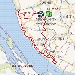
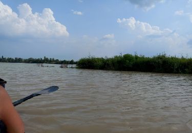
Randonnée Marche de 19,4 km à découvrir à Nouvelle-Aquitaine, Gironde, Saint-Ciers-de-Canesse. Cette randonnée est proposée par JACQUOU.
Description
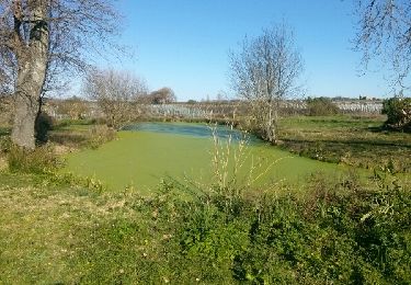
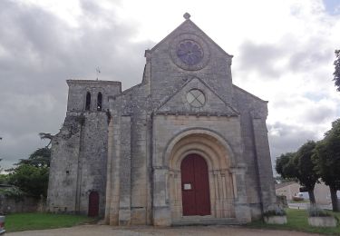
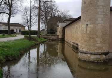
Départ de St Ciers de Canesse en passant par la Roque de Thau, l'escalier des troglodytes, le bord de l'estuaire, le château Eyquen avec la vue surl le Bec d'Ambés et retour.
Localisation
Pays :
France
Région :
Nouvelle-Aquitaine
Département/Province :
Gironde
Commune :
Saint-Ciers-de-Canesse
Localité :
Unknown
Départ:(Dec)
Départ:(UTM)
688087 ; 4995034 (30T) N.
Commentaires
Randonnées à proximité
![Randonnée Marche Gauriac - Corniche de Gironde - Photo](https://media.geolcdn.com/t/375/260/ext.jpg?maxdim=2&url=https%3A%2F%2Fservices.sitytrail.com%2FGeolivesWS%2FDownloadMedia.ashx%3FTrailID%3D271558%26Media%3Dfix__20140309161312.jpg)
![Marche Marche](https://static1.geolcdn.com/sitytour/trail-icons/101.png)
Corniche de Gironde
Marche
Moyen
(3)
Gauriac,
Nouvelle-Aquitaine,
Gironde,
France
![](/images/other/stat-length.png)
14,1 km | 16,8 km-effort
3h 15min
![](https://static1.geolcdn.com/siteimages/upload/files/16400158638029165_repeat_loop_refresh_sync_direction_icon.png)
Oui
![Randonnée A pied Villeneuve - Balade de l'Estuaire - Photo](https://media.geolcdn.com/t/375/260/70ced56f-ce74-4a0d-8474-be54a1713be3.jpeg&format=jpg&maxdim=2)
![A pied A pied](https://static1.geolcdn.com/sitytour/trail-icons/100.png)
Balade de l'Estuaire
A pied
Facile
Villeneuve,
Nouvelle-Aquitaine,
Gironde,
France
![](/images/other/stat-length.png)
13,2 km | 15,8 km-effort
3h 35min
![](https://static1.geolcdn.com/siteimages/upload/files/16400158638029165_repeat_loop_refresh_sync_direction_icon.png)
Oui
![Randonnée Marche Bayon-sur-Gironde - Bayon ses vignes et la Gironde - Photo](https://media.geolcdn.com/t/375/260/17337f03-d723-4bb3-bf19-fe5875f8d73d.jpg&format=jpg&maxdim=2)
![Marche Marche](https://static1.geolcdn.com/sitytour/trail-icons/101.png)
Bayon ses vignes et la Gironde
Marche
Très facile
Bayon-sur-Gironde,
Nouvelle-Aquitaine,
Gironde,
France
![](/images/other/stat-length.png)
3,6 km | 4,2 km-effort
55min
![](https://static1.geolcdn.com/siteimages/upload/files/16400158638029165_repeat_loop_refresh_sync_direction_icon.png)
Oui
![Randonnée Marche Margaux-Cantenac - Margaux - Photo](https://media.geolcdn.com/t/375/260/ca4cf701-6f06-49a0-b9b1-efb58a53d587.jpg&format=jpg&maxdim=2)
![Marche Marche](https://static1.geolcdn.com/sitytour/trail-icons/101.png)
Margaux
Marche
Facile
Margaux-Cantenac,
Nouvelle-Aquitaine,
Gironde,
France
![](/images/other/stat-length.png)
11,4 km | 12,2 km-effort
2h 23min
![](https://static1.geolcdn.com/siteimages/upload/files/16400158638029165_repeat_loop_refresh_sync_direction_icon.png)
Oui
![Randonnée Marche Gauriac - Le nord de l'estuaire - Photo](https://media.geolcdn.com/t/375/260/ext.jpg?maxdim=2&url=https%3A%2F%2Fservices.sitytrail.com%2FGeolivesWS%2FDownloadMedia.ashx%3FTrailID%3D711959%26Media%3Dfix__20170311123621.jpg)
![Marche Marche](https://static1.geolcdn.com/sitytour/trail-icons/101.png)
Le nord de l'estuaire
Marche
Moyen
Gauriac,
Nouvelle-Aquitaine,
Gironde,
France
![](/images/other/stat-length.png)
14,8 km | 17,9 km-effort
2h 52min
![](https://static1.geolcdn.com/siteimages/upload/files/16400158638029165_repeat_loop_refresh_sync_direction_icon.png)
Oui
![Randonnée Autre activité Margaux-Cantenac - Blaye en kayak - Photo](https://media.geolcdn.com/t/375/260/ext.jpg?maxdim=2&url=https%3A%2F%2Fservices.sitytrail.com%2FGeolivesWS%2FDownloadMedia.ashx%3FTrailID%3D327412%26Media%3Dfix__20140724174919.jpg)
![Autre activité Autre activité](https://static1.geolcdn.com/sitytour/trail-icons/900.png)
Blaye en kayak
Autre activité
Moyen
Margaux-Cantenac,
Nouvelle-Aquitaine,
Gironde,
France
![](/images/other/stat-length.png)
32 km | 33 km-effort
5h 9min
![](https://static1.geolcdn.com/siteimages/upload/files/16400158638029165_repeat_loop_refresh_sync_direction_icon.png)
Oui
![Randonnée Marche Mombrier - 20/10/24 - Photo](https://media.geolcdn.com/t/375/260/ext.jpg?maxdim=2&url=https%3A%2F%2Fstatic1.geolcdn.com%2Fsiteimages%2Fupload%2Ffiles%2F1553511878bg_sport_marche.png)
![Marche Marche](https://static1.geolcdn.com/sitytour/trail-icons/101.png)
20/10/24
Marche
Moyen
Mombrier,
Nouvelle-Aquitaine,
Gironde,
France
![](/images/other/stat-length.png)
8 km | 9,2 km-effort
1h 48min
![](https://static1.geolcdn.com/siteimages/upload/files/16400158638029165_repeat_loop_refresh_sync_direction_icon.png)
Oui
![Randonnée Marche Bourg - Boucle de la Libarde - Photo](https://media.geolcdn.com/t/375/260/ext.jpg?maxdim=2&url=https%3A%2F%2Fstatic1.geolcdn.com%2Fsiteimages%2Fupload%2Ffiles%2F1553511878bg_sport_marche.png)
![Marche Marche](https://static1.geolcdn.com/sitytour/trail-icons/101.png)
Boucle de la Libarde
Marche
Moyen
Bourg,
Nouvelle-Aquitaine,
Gironde,
France
![](/images/other/stat-length.png)
9,8 km | 12,1 km-effort
2h 44min
![](https://static1.geolcdn.com/siteimages/upload/files/16400158638029165_repeat_loop_refresh_sync_direction_icon.png)
Oui
![Randonnée Marche Bourg - Bourg flânerie - Photo](https://media.geolcdn.com/t/375/260/ext.jpg?maxdim=2&url=https%3A%2F%2Fstatic1.geolcdn.com%2Fsiteimages%2Fupload%2Ffiles%2F1553511878bg_sport_marche.png)
![Marche Marche](https://static1.geolcdn.com/sitytour/trail-icons/101.png)
Bourg flânerie
Marche
Facile
Bourg,
Nouvelle-Aquitaine,
Gironde,
France
![](/images/other/stat-length.png)
5,4 km | 6,4 km-effort
1h 34min
![](https://static1.geolcdn.com/siteimages/upload/files/16400158638029165_repeat_loop_refresh_sync_direction_icon.png)
Oui