![](/images/other/stat-length.png)
![Randonnée Marche Pézènes-les-Mines - La Braunhe et les anciennes carrières de bauxite - Photo](https://media.geolcdn.com/t/1900/400/ext.pjpeg?maxdim=2&url=https%3A%2F%2Fstatic1.geolcdn.com%2Fsiteimages%2Fupload%2Ffiles%2F1553511878bg_sport_marche.png)
La Braunhe et les anciennes carrières de bauxite
grageot
Utilisateur
![Longueur](/images/other/stat-length.png)
![Altitude max](https://static1.geolcdn.com/siteimages/upload/files/1508320355ic_sort_altitude_max_24dp.png)
![Dénivelé positif](https://static1.geolcdn.com/siteimages/upload/files/1508320355ic_sort_den_pos_24dp.png)
![Km-Effort](/images/other/stat-length.png)
![Altitude min](https://static1.geolcdn.com/siteimages/upload/files/1508320355ic_sort_altitude_min_24dp.png)
![Dénivelé négatif](https://static1.geolcdn.com/siteimages/upload/files/1508320355ic_sort_den_neg_24dp.png)
![Boucle](https://static1.geolcdn.com/siteimages/upload/files/16400158638029165_repeat_loop_refresh_sync_direction_icon.png)
![Marche](https://static1.geolcdn.com/sitytour/trail-icons/101.png)
4h22
Difficulté : Moyen
![Scannez ce code QR pour ouvrir la randonnée dans l'application SityTrail](https://capi.geolives.com/qq0zvz2zws4bq2lad0pu/sitytour/trails/2056747/qr.png?size=200)
Application GPS de randonnée GRATUITE
À propos
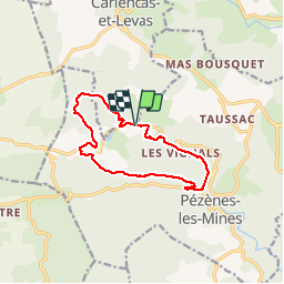
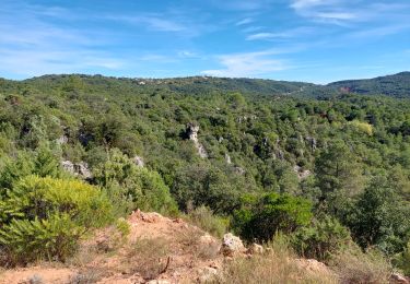
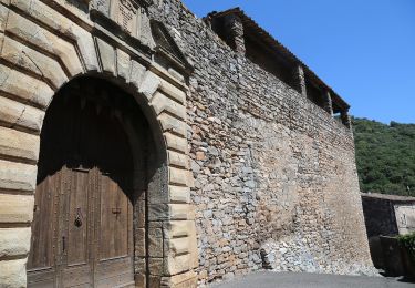
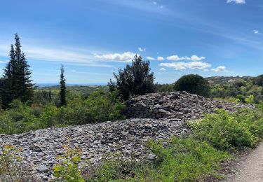
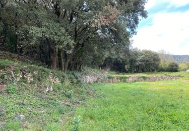
Randonnée Marche de 12,4 km à découvrir à Occitanie, Hérault, Pézènes-les-Mines. Cette randonnée est proposée par grageot.
Description
Avril 2019 - parking sur le bord de la route dans le hameau : pas trop de place. Les anciennes carrières de l'Arboussas étant de nouveau en activité toute la zone est fermée. Pas de difficultés topo sauf en quittant la D149 pour monter sur la ligne de crête, les sentiers ne sont pas où ils sont indiqués sur la carte. Bien suivre le tracé qui est un sentier plus ou moins marqué pour rejoindre la piste qui monte à la cote 403
Localisation
Commentaires
Randonnées à proximité
![Randonnée Marche nordique Mérifons - Malavieille - Montagne de la Boutine - Photo](https://media.geolcdn.com/t/375/260/8aab6b2b-89ba-4093-96e5-b63d668fdd27.jpg&format=jpg&maxdim=2)
![Marche nordique Marche nordique](https://static1.geolcdn.com/sitytour/trail-icons/102.png)
Marche nordique
![](/images/other/stat-length.png)
![](https://static1.geolcdn.com/siteimages/upload/files/16400158638029165_repeat_loop_refresh_sync_direction_icon.png)
![Randonnée Marche Mérifons - Chemin Vicinal N°13 de Carlencas - Photo](https://media.geolcdn.com/t/375/260/ext.jpg?maxdim=2&url=https%3A%2F%2Fservices.sitytrail.com%2FGeolivesWS%2FDownloadMedia.ashx%3FTrailID%3D924493%26Media%3D40107a9e-9964-4bb5-99a1-0b5e778d47e3.jpg)
![Marche Marche](https://static1.geolcdn.com/sitytour/trail-icons/101.png)
Marche
![](/images/other/stat-length.png)
![](https://static1.geolcdn.com/siteimages/upload/files/16400158638029165_repeat_loop_refresh_sync_direction_icon.png)
![Randonnée Marche Pézènes-les-Mines - PEZENES les mines / FOS - Photo](https://media.geolcdn.com/t/375/260/ext.jpg?maxdim=2&url=https%3A%2F%2Fservices.sitytrail.com%2FGeolivesWS%2FDownloadMedia.ashx%3FTrailID%3D433550%26Media%3D20150614152939.jpg)
![Marche Marche](https://static1.geolcdn.com/sitytour/trail-icons/101.png)
Marche
![](/images/other/stat-length.png)
![](https://static1.geolcdn.com/siteimages/upload/files/16400158638029165_repeat_loop_refresh_sync_direction_icon.png)
![Randonnée Marche Carlencas-et-Levas - Carlencas - Photo](https://media.geolcdn.com/t/375/260/0339a666-2d2a-4cee-8c31-0571be47d361.jpg&format=jpg&maxdim=2)
![Marche Marche](https://static1.geolcdn.com/sitytour/trail-icons/101.png)
Marche
![](/images/other/stat-length.png)
![](https://static1.geolcdn.com/siteimages/upload/files/16400158638029165_repeat_loop_refresh_sync_direction_icon.png)
![Randonnée A pied Montesquieu - Pézènes-les-Mines : vallée de la Peyne et village de Fos - Photo](https://media.geolcdn.com/t/375/260/1b3320ad-a3ad-44af-a9f6-9c0635cf9e23.jpeg&format=jpg&maxdim=2)
![A pied A pied](https://static1.geolcdn.com/sitytour/trail-icons/100.png)
A pied
![](/images/other/stat-length.png)
![](https://static1.geolcdn.com/siteimages/upload/files/16400158638029165_repeat_loop_refresh_sync_direction_icon.png)
![Randonnée A pied Pézènes-les-Mines - Le Dolmen de Pézènes - Photo](https://media.geolcdn.com/t/375/260/c555ea4a-5e40-4fbc-b83f-822db13b9bf6.jpeg&format=jpg&maxdim=2)
![A pied A pied](https://static1.geolcdn.com/sitytour/trail-icons/100.png)
A pied
![](/images/other/stat-length.png)
![](https://static1.geolcdn.com/siteimages/upload/files/16400158638029165_repeat_loop_refresh_sync_direction_icon.png)
![Randonnée Marche nordique Mérifons - Mérifons - Carlencas AR - Photo](https://media.geolcdn.com/t/375/260/a770fbc1-c7cd-47c4-b2d3-2a462f8e1e13.jpg&format=jpg&maxdim=2)
![Marche nordique Marche nordique](https://static1.geolcdn.com/sitytour/trail-icons/102.png)
Marche nordique
![](/images/other/stat-length.png)
![](https://static1.geolcdn.com/siteimages/upload/files/16400158638029165_repeat_loop_refresh_sync_direction_icon.png)
![Randonnée Marche Faugères - Faugeres pouzes - Photo](https://media.geolcdn.com/t/375/260/4bb31b51-4ced-4c17-adb8-0d1bcb2cdf11.jpg&format=jpg&maxdim=2)
![Marche Marche](https://static1.geolcdn.com/sitytour/trail-icons/101.png)
![Randonnée Marche Faugères - Balade Faugeres / les Mates Basses - Photo](https://media.geolcdn.com/t/375/260/0fdc69b4-7b36-47ba-9580-4b42654f6fdc.jpg&format=jpg&maxdim=2)
![Marche Marche](https://static1.geolcdn.com/sitytour/trail-icons/101.png)
Marche
![](/images/other/stat-length.png)
![](https://static1.geolcdn.com/siteimages/upload/files/16400158638029165_repeat_loop_refresh_sync_direction_icon.png)