![](/images/other/stat-length.png)
![Randonnée Marche Jausiers - Sentier de Costebelle - Photo](https://media.geolcdn.com/t/1900/400/a099bdd7-81ad-4f0f-8b3b-53e7f39d9a69.jpg&format=pjpeg&maxdim=2)
Sentier de Costebelle
GAPIAN43
Utilisateur
![Longueur](/images/other/stat-length.png)
![Altitude max](https://static1.geolcdn.com/siteimages/upload/files/1508320355ic_sort_altitude_max_24dp.png)
![Dénivelé positif](https://static1.geolcdn.com/siteimages/upload/files/1508320355ic_sort_den_pos_24dp.png)
![Km-Effort](/images/other/stat-length.png)
![Altitude min](https://static1.geolcdn.com/siteimages/upload/files/1508320355ic_sort_altitude_min_24dp.png)
![Dénivelé négatif](https://static1.geolcdn.com/siteimages/upload/files/1508320355ic_sort_den_neg_24dp.png)
![Boucle](https://static1.geolcdn.com/siteimages/upload/files/16400158638029165_repeat_loop_refresh_sync_direction_icon.png)
![Marche](https://static1.geolcdn.com/sitytour/trail-icons/101.png)
6h24
Difficulté : Difficile
![Scannez ce code QR pour ouvrir la randonnée dans l'application SityTrail](https://capi.geolives.com/qq0zvz2zws4bq2lad0pu/sitytour/trails/2056699/qr.png?size=200)
Application GPS de randonnée GRATUITE
À propos
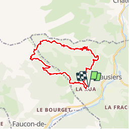
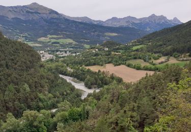
Randonnée Marche de 15,7 km à découvrir à Provence-Alpes-Côte d'Azur, Alpes-de-Haute-Provence, Jausiers. Cette randonnée est proposée par GAPIAN43.
Description
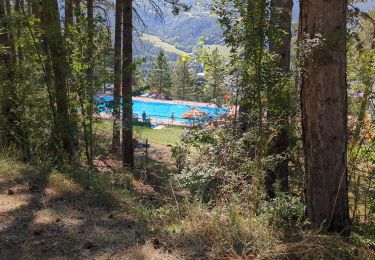
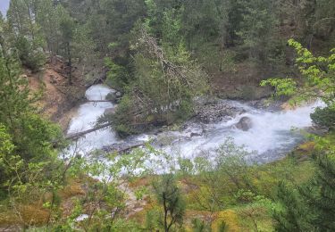
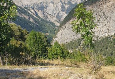
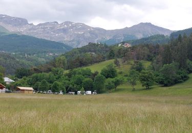
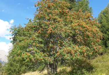
Sentier de Costebelle depuis la Rochette. Suite à un gros éboulement le retour vers Charenc n'est plus possible. Il faut maintenant partir de la Rochette. 200m de déniv en plus et 3km. La traversée du ravin de Frusta (dernière ravine avant de descente sur la MF de Belmont) est assez délicate le sentier a été emporté et la ravine est assez délicate à traverser. Superbe randonnée.
Localisation
Commentaires
Randonnées à proximité
![Randonnée Marche Faucon-de-Barcelonnette - Pre de RATA et St Flavie - Photo](https://media.geolcdn.com/t/375/260/154d9cc8-7061-4846-bde4-1f8e811ca32f.jpeg&format=jpg&maxdim=2)
![Marche Marche](https://static1.geolcdn.com/sitytour/trail-icons/101.png)
Marche
![](/images/other/stat-length.png)
![](https://static1.geolcdn.com/siteimages/upload/files/16400158638029165_repeat_loop_refresh_sync_direction_icon.png)
![Randonnée V.T.T. Jausiers - Espace VTT FFC Vallée de l'Ubaye - Circuit n° 01 - La Tour des Sagnes - Photo](https://media.geolcdn.com/t/375/260/ext.jpg?maxdim=2&url=https%3A%2F%2Fservices.sitytrail.com%2FGeolivesWS%2FDownloadMedia.ashx%3FTrailID%3D102299%26Media%3D2764_1.jpg)
![V.T.T. V.T.T.](https://static1.geolcdn.com/sitytour/trail-icons/202.png)
V.T.T.
![](/images/other/stat-length.png)
![](https://static1.geolcdn.com/siteimages/upload/files/16400158638029165_repeat_loop_refresh_sync_direction_icon.png)
![Randonnée Marche Jausiers - Fontaine de la pissoun 15-08-12 - Photo](https://media.geolcdn.com/t/375/260/ext.jpg?maxdim=2&url=https%3A%2F%2Fstatic1.geolcdn.com%2Fsiteimages%2Fupload%2Ffiles%2F1553511878bg_sport_marche.png)
![Marche Marche](https://static1.geolcdn.com/sitytour/trail-icons/101.png)
Marche
![](/images/other/stat-length.png)
![](https://static1.geolcdn.com/siteimages/upload/files/16400158638029165_repeat_loop_refresh_sync_direction_icon.png)
![Randonnée Vélo électrique Jausiers - Flavi Barcelonnette - Photo](https://media.geolcdn.com/t/375/260/c8c960c1-cd70-45b7-be5e-7238e8edcc3d.jpg&format=jpg&maxdim=2)
![Vélo électrique Vélo électrique](https://static1.geolcdn.com/sitytour/trail-icons/205.png)
Vélo électrique
![](/images/other/stat-length.png)
![](https://static1.geolcdn.com/siteimages/upload/files/16400158638029165_repeat_loop_refresh_sync_direction_icon.png)
![Randonnée Marche Jausiers - cascadede pissoun 24 06 2024 - Photo](https://media.geolcdn.com/t/375/260/5ad66409-df89-4698-a4d8-4799e98719e1.jpg&format=jpg&maxdim=2)
![Marche Marche](https://static1.geolcdn.com/sitytour/trail-icons/101.png)
Marche
![](/images/other/stat-length.png)
![](https://static1.geolcdn.com/siteimages/upload/files/16400158638029165_repeat_loop_refresh_sync_direction_icon.png)
![Randonnée Marche Jausiers - Pas de Grégoire /Chatelard - Photo](https://media.geolcdn.com/t/375/260/e3cd2f53-ab66-4d2b-85bb-ff61af04fea5.jpg&format=jpg&maxdim=2)
![Marche Marche](https://static1.geolcdn.com/sitytour/trail-icons/101.png)
Marche
![](/images/other/stat-length.png)
![](https://static1.geolcdn.com/siteimages/upload/files/16400158638029165_repeat_loop_refresh_sync_direction_icon.png)
![Randonnée Marche Enchastrayes - PETIT TOUR A BARCELONNETTE - Photo](https://media.geolcdn.com/t/375/260/761611be-210f-4c71-b07b-9bcca4672493.jpg&format=jpg&maxdim=2)
![Marche Marche](https://static1.geolcdn.com/sitytour/trail-icons/101.png)
Marche
![](/images/other/stat-length.png)
![](https://static1.geolcdn.com/siteimages/upload/files/16400158638029165_repeat_loop_refresh_sync_direction_icon.png)
![Randonnée Marche Enchastrayes - Aupillon-cabane basse 04 - Photo](https://media.geolcdn.com/t/375/260/c4e540ee-f37d-4ae4-b1f2-58b6027df7e9.jpg&format=jpg&maxdim=2)
![Marche Marche](https://static1.geolcdn.com/sitytour/trail-icons/101.png)
Marche
![](/images/other/stat-length.png)
![](https://static1.geolcdn.com/siteimages/upload/files/16400158638029165_repeat_loop_refresh_sync_direction_icon.png)
![Randonnée Marche Jausiers - Petite ballade autour du pas de Grégoire - Photo](https://media.geolcdn.com/t/375/260/26139b91-bf05-4c45-b67d-aa102294f739.jpg&format=jpg&maxdim=2)
![Marche Marche](https://static1.geolcdn.com/sitytour/trail-icons/101.png)
Marche
![](/images/other/stat-length.png)
![](https://static1.geolcdn.com/siteimages/upload/files/16400158638029165_repeat_loop_refresh_sync_direction_icon.png)