![](/images/other/stat-length.png)
![Randonnée Marche Chorges - 20190331_Clot Clavary - Photo](https://media.geolcdn.com/t/1900/400/b6656e86-086d-47c4-9f1b-2c7b3f3ccd77.jpg&format=pjpeg&maxdim=2)
20190331_Clot Clavary
PapouBertrand
Utilisateur
![Longueur](/images/other/stat-length.png)
Longueur
10,3 km
![Altitude max](https://static1.geolcdn.com/siteimages/upload/files/1508320355ic_sort_altitude_max_24dp.png)
Altitude max
1551 m
![Dénivelé positif](https://static1.geolcdn.com/siteimages/upload/files/1508320355ic_sort_den_pos_24dp.png)
Dénivelé positif
407 m
![Km-Effort](/images/other/stat-length.png)
Km-Effort
15,7 km
![Altitude min](https://static1.geolcdn.com/siteimages/upload/files/1508320355ic_sort_altitude_min_24dp.png)
Altitude min
1158 m
![Dénivelé négatif](https://static1.geolcdn.com/siteimages/upload/files/1508320355ic_sort_den_neg_24dp.png)
Dénivelé négatif
397 m
![Boucle](https://static1.geolcdn.com/siteimages/upload/files/16400158638029165_repeat_loop_refresh_sync_direction_icon.png)
Boucle
Oui
Date de création :
2019-03-31 08:38:48.346
Dernière modification :
2019-04-09 18:45:05.66
![Marche](https://static1.geolcdn.com/sitytour/trail-icons/101.png)
2h46
Difficulté : Facile
![Scannez ce code QR pour ouvrir la randonnée dans l'application SityTrail](https://capi.geolives.com/qq0zvz2zws4bq2lad0pu/sitytour/trails/2055000/qr.png?size=200)
Application GPS de randonnée GRATUITE
À propos
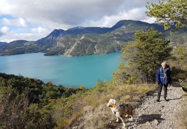
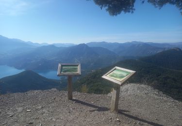
Randonnée Marche de 10,3 km à découvrir à Provence-Alpes-Côte d'Azur, Hautes-Alpes, Chorges. Cette randonnée est proposée par PapouBertrand.
Description
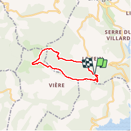
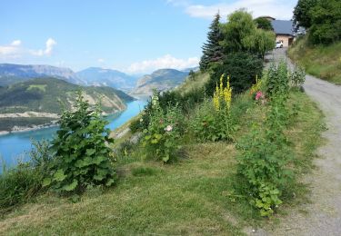
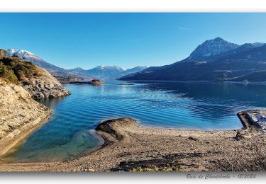
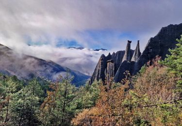
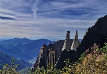
Randonnée Marche de 10 km et 400 mètres de dénivelé à découvrir à CHORGES, HAUTES-ALPES, PROVENCE-ALPES-COTE D'AZUR, départ près du col Lebraut. Cette petite randonnée sans difficulté technique offre de beau point de vue.
Localisation
Pays :
France
Région :
Provence-Alpes-Côte d'Azur
Département/Province :
Hautes-Alpes
Commune :
Chorges
Localité :
Unknown
Départ:(Dec)
Départ:(UTM)
283146 ; 4931936 (32T) N.
Commentaires
Randonnées à proximité
![Randonnée Marche Chorges - Chanteloube et lac de Serre Ponçon - Photo](https://media.geolcdn.com/t/375/260/ext.jpg?maxdim=2&url=https%3A%2F%2Fservices.sitytrail.com%2FGeolivesWS%2FDownloadMedia.ashx%3FTrailID%3D337864%26Media%3Dfix__20140822114842.jpg)
![Marche Marche](https://static1.geolcdn.com/sitytour/trail-icons/101.png)
Chanteloube et lac de Serre Ponçon
Marche
Très facile
(2)
Chorges,
Provence-Alpes-Côte d'Azur,
Hautes-Alpes,
France
![](/images/other/stat-length.png)
5,9 km | 8,2 km-effort
1h 47min
![](https://static1.geolcdn.com/siteimages/upload/files/16400158638029165_repeat_loop_refresh_sync_direction_icon.png)
Oui
![Randonnée Marche Chorges - clôt c l'avais sur fein - Photo](https://media.geolcdn.com/t/375/260/ext.jpg?maxdim=2&url=https%3A%2F%2Fservices.sitytrail.com%2FGeolivesWS%2FDownloadMedia.ashx%3FTrailID%3D306998%26Media%3Dfix__20140529172433.jpg)
![Marche Marche](https://static1.geolcdn.com/sitytour/trail-icons/101.png)
clôt c l'avais sur fein
Marche
Très facile
(2)
Chorges,
Provence-Alpes-Côte d'Azur,
Hautes-Alpes,
France
![](/images/other/stat-length.png)
8 km | 12,6 km-effort
2h 24min
![](https://static1.geolcdn.com/siteimages/upload/files/16400158638029165_repeat_loop_refresh_sync_direction_icon.png)
Oui
![Randonnée Marche Le Sauze-du-Lac - Le Sauze-du-Lac - Port St-Pierre - 5.1km 275m 2h10 - 2018 06 29 - Photo](https://media.geolcdn.com/t/375/260/ext.jpg?maxdim=2&url=https%3A%2F%2Fservices.sitytrail.com%2FGeolivesWS%2FDownloadMedia.ashx%3FTrailID%3D999114%26Media%3Dfix__20180629102822.jpg)
![Marche Marche](https://static1.geolcdn.com/sitytour/trail-icons/101.png)
Le Sauze-du-Lac - Port St-Pierre - 5.1km 275m 2h10 - 2018 06 29
Marche
Facile
Le Sauze-du-Lac,
Provence-Alpes-Côte d'Azur,
Hautes-Alpes,
France
![](/images/other/stat-length.png)
5,1 km | 8,8 km-effort
2h 10min
![](https://static1.geolcdn.com/siteimages/upload/files/16400158638029165_repeat_loop_refresh_sync_direction_icon.png)
Oui
![Randonnée Marche Chorges - Montagne du Ruban - Photo](https://media.geolcdn.com/t/375/260/ext.jpg?maxdim=2&url=https%3A%2F%2Fstatic1.geolcdn.com%2Fsiteimages%2Fupload%2Ffiles%2F1553511878bg_sport_marche.png)
![Marche Marche](https://static1.geolcdn.com/sitytour/trail-icons/101.png)
Montagne du Ruban
Marche
Facile
(2)
Chorges,
Provence-Alpes-Côte d'Azur,
Hautes-Alpes,
France
![](/images/other/stat-length.png)
11 km | 17,4 km-effort
3h 39min
![](https://static1.geolcdn.com/siteimages/upload/files/16400158638029165_repeat_loop_refresh_sync_direction_icon.png)
Non
![Randonnée Marche Chorges - De la baie de Chanteloube à celle de Saint-Michel - Retour par le Belvédère des Curattes - Photo](https://media.geolcdn.com/t/375/260/30a4afde-c6d7-4d24-9e6c-05905d1a1dbf.jpg&format=jpg&maxdim=2)
![Marche Marche](https://static1.geolcdn.com/sitytour/trail-icons/101.png)
De la baie de Chanteloube à celle de Saint-Michel - Retour par le Belvédère d...
Marche
Difficile
Chorges,
Provence-Alpes-Côte d'Azur,
Hautes-Alpes,
France
![](/images/other/stat-length.png)
8,4 km | 12,8 km-effort
2h 55min
![](https://static1.geolcdn.com/siteimages/upload/files/16400158638029165_repeat_loop_refresh_sync_direction_icon.png)
Oui
![Randonnée Marche Espinasses - Salle de bal des Demoiselles Coiffées via Serre Giraud - Photo](https://media.geolcdn.com/t/375/260/308e4b93-b724-42e4-abd4-cc3772156253.jpg&format=jpg&maxdim=2)
![Marche Marche](https://static1.geolcdn.com/sitytour/trail-icons/101.png)
Salle de bal des Demoiselles Coiffées via Serre Giraud
Marche
Très difficile
Espinasses,
Provence-Alpes-Côte d'Azur,
Hautes-Alpes,
France
![](/images/other/stat-length.png)
9,6 km | 21 km-effort
4h 48min
![](https://static1.geolcdn.com/siteimages/upload/files/16400158638029165_repeat_loop_refresh_sync_direction_icon.png)
Oui
![Randonnée Marche Espinasses - Les Demoiselles Coiffées d'Espinasses Théus et Remollon - Photo](https://media.geolcdn.com/t/375/260/1af52faf-437c-42bd-b3af-b635ea9a33d1.jpg&format=jpg&maxdim=2)
![Marche Marche](https://static1.geolcdn.com/sitytour/trail-icons/101.png)
Les Demoiselles Coiffées d'Espinasses Théus et Remollon
Marche
Très difficile
Espinasses,
Provence-Alpes-Côte d'Azur,
Hautes-Alpes,
France
![](/images/other/stat-length.png)
10,5 km | 21 km-effort
4h 42min
![](https://static1.geolcdn.com/siteimages/upload/files/16400158638029165_repeat_loop_refresh_sync_direction_icon.png)
Non
![Randonnée Marche Le Sauze-du-Lac - Balcons du lac Taïga - Photo](https://media.geolcdn.com/t/375/260/78801efe-4ea5-4d79-aa98-ade291d85566.jpg&format=jpg&maxdim=2)
![Marche Marche](https://static1.geolcdn.com/sitytour/trail-icons/101.png)
Balcons du lac Taïga
Marche
Facile
Le Sauze-du-Lac,
Provence-Alpes-Côte d'Azur,
Hautes-Alpes,
France
![](/images/other/stat-length.png)
7,5 km | 11,1 km-effort
3h 12min
![](https://static1.geolcdn.com/siteimages/upload/files/16400158638029165_repeat_loop_refresh_sync_direction_icon.png)
Oui
![Randonnée Marche Chorges - Clôt Clavary 3.9.23 - Photo](https://media.geolcdn.com/t/375/260/e339989a-4af8-4e0a-b588-3657ae86e079.jpg&format=jpg&maxdim=2)
![Marche Marche](https://static1.geolcdn.com/sitytour/trail-icons/101.png)
Clôt Clavary 3.9.23
Marche
Facile
Chorges,
Provence-Alpes-Côte d'Azur,
Hautes-Alpes,
France
![](/images/other/stat-length.png)
7,1 km | 11,6 km-effort
2h 0min
![](https://static1.geolcdn.com/siteimages/upload/files/16400158638029165_repeat_loop_refresh_sync_direction_icon.png)
Oui