![](/images/other/stat-length.png)
![Randonnée Marche Èze - Mont Bastide, sentier de Nietzsche - Photo](https://media.geolcdn.com/t/1900/400/ext.pjpeg?maxdim=2&url=https%3A%2F%2Fstatic1.geolcdn.com%2Fsiteimages%2Fupload%2Ffiles%2F1553511878bg_sport_marche.png)
Mont Bastide, sentier de Nietzsche
PEBREJOSIANE
Utilisateur
![Longueur](/images/other/stat-length.png)
Longueur
7,2 km
![Altitude max](https://static1.geolcdn.com/siteimages/upload/files/1508320355ic_sort_altitude_max_24dp.png)
Altitude max
552 m
![Dénivelé positif](https://static1.geolcdn.com/siteimages/upload/files/1508320355ic_sort_den_pos_24dp.png)
Dénivelé positif
593 m
![Km-Effort](/images/other/stat-length.png)
Km-Effort
15,1 km
![Altitude min](https://static1.geolcdn.com/siteimages/upload/files/1508320355ic_sort_altitude_min_24dp.png)
Altitude min
20 m
![Dénivelé négatif](https://static1.geolcdn.com/siteimages/upload/files/1508320355ic_sort_den_neg_24dp.png)
Dénivelé négatif
590 m
![Boucle](https://static1.geolcdn.com/siteimages/upload/files/16400158638029165_repeat_loop_refresh_sync_direction_icon.png)
Boucle
Oui
Date de création :
2019-03-30 07:39:11.745
Dernière modification :
2019-03-30 13:08:21.798
![Marche](https://static1.geolcdn.com/sitytour/trail-icons/101.png)
3h15
Difficulté : Facile
![Nage](https://static1.geolcdn.com/sitytour/trail-icons/704.png)
30m
Difficulté : Très facile
![Scannez ce code QR pour ouvrir la randonnée dans l'application SityTrail](https://capi.geolives.com/qq0zvz2zws4bq2lad0pu/sitytour/trails/2054357/qr.png?size=200)
Application GPS de randonnée GRATUITE
À propos
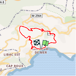
Randonnée Marche de 7,2 km à découvrir à Provence-Alpes-Côte d'Azur, Alpes-Maritimes, Èze. Cette randonnée est proposée par PEBREJOSIANE.
Description
Agréable randonnée, bien ombragée à la montée, avec de superbes vues sur la côte.
La descente s'effectue en plein soleil, prévoir de partir suffisamment tôt pour ne pas avoir trop chaud.
Baignade à 100m du départ/arrivée pour se rafraîchir
Localisation
Pays :
France
Région :
Provence-Alpes-Côte d'Azur
Département/Province :
Alpes-Maritimes
Commune :
Èze
Localité :
Unknown
Départ:(Dec)
Départ:(UTM)
367640 ; 4842316 (32T) N.
Commentaires
Randonnées à proximité
![Randonnée Marche Saint-Jean-Cap-Ferrat - Cap Ferrat 2011-10-27 - Photo](https://media.geolcdn.com/t/375/260/ext.jpg?maxdim=2&url=https%3A%2F%2Fservices.sitytrail.com%2FGeolivesWS%2FDownloadMedia.ashx%3FTrailID%3D89946%26Media%3D20111027142707.jpeg)
![Marche Marche](https://static1.geolcdn.com/sitytour/trail-icons/101.png)
Cap Ferrat 2011-10-27
Marche
Moyen
(2)
Saint-Jean-Cap-Ferrat,
Provence-Alpes-Côte d'Azur,
Alpes-Maritimes,
France
![](/images/other/stat-length.png)
10,9 km | 14 km-effort
4h 0min
![](https://static1.geolcdn.com/siteimages/upload/files/16400158638029165_repeat_loop_refresh_sync_direction_icon.png)
Oui
![Randonnée Marche Cantaron - Cantaron : Monts Macaron et Ubac par Levens Tourette réelle - Photo](https://media.geolcdn.com/t/375/260/60da6868-ad90-4803-993b-f92b5b64ec1d.jpg&format=jpg&maxdim=2)
![Marche Marche](https://static1.geolcdn.com/sitytour/trail-icons/101.png)
Cantaron : Monts Macaron et Ubac par Levens Tourette réelle
Marche
Très difficile
Cantaron,
Provence-Alpes-Côte d'Azur,
Alpes-Maritimes,
France
![](/images/other/stat-length.png)
19,7 km | 35 km-effort
7h 57min
![](https://static1.geolcdn.com/siteimages/upload/files/16400158638029165_repeat_loop_refresh_sync_direction_icon.png)
Oui
![Randonnée Marche Cap-d'Ail - Nice Cap d'Ail en train et retour par les cretes - Photo](https://media.geolcdn.com/t/375/260/7204d697-fda1-4f9c-b0e7-68e4876276d3.jpg&format=jpg&maxdim=2)
![Marche Marche](https://static1.geolcdn.com/sitytour/trail-icons/101.png)
Nice Cap d'Ail en train et retour par les cretes
Marche
Très difficile
Cap-d'Ail,
Provence-Alpes-Côte d'Azur,
Alpes-Maritimes,
France
![](/images/other/stat-length.png)
23 km | 36 km-effort
8h 6min
![](https://static1.geolcdn.com/siteimages/upload/files/16400158638029165_repeat_loop_refresh_sync_direction_icon.png)
Non
![Randonnée A pied Èze - Circuit du mont Bastide - Photo](https://media.geolcdn.com/t/375/260/5ad7717b-c841-4266-a29b-c036d9f61957.jpeg&format=jpg&maxdim=2)
![A pied A pied](https://static1.geolcdn.com/sitytour/trail-icons/100.png)
Circuit du mont Bastide
A pied
Facile
Èze,
Provence-Alpes-Côte d'Azur,
Alpes-Maritimes,
France
![](/images/other/stat-length.png)
7 km | 14,7 km-effort
3h 20min
![](https://static1.geolcdn.com/siteimages/upload/files/16400158638029165_repeat_loop_refresh_sync_direction_icon.png)
Oui
![Randonnée Autre activité La Turbie - fort de la Revere - Photo](https://media.geolcdn.com/t/375/260/ext.jpg?maxdim=2&url=https%3A%2F%2Fstatic1.geolcdn.com%2Fsiteimages%2Fupload%2Ffiles%2F1545311037marcheuse_200dpi.jpg)
![Autre activité Autre activité](https://static1.geolcdn.com/sitytour/trail-icons/900.png)
fort de la Revere
Autre activité
Très facile
(1)
La Turbie,
Provence-Alpes-Côte d'Azur,
Alpes-Maritimes,
France
![](/images/other/stat-length.png)
8,4 km | 12 km-effort
1h 37min
![](https://static1.geolcdn.com/siteimages/upload/files/16400158638029165_repeat_loop_refresh_sync_direction_icon.png)
Oui
![Randonnée Marche Saint-Jean-Cap-Ferrat - Saint-Jean-Cap-Ferrat - Tour du Cap Ferrat - 7.1km 170m 1h40 - 2015 06 13 - Photo](https://media.geolcdn.com/t/375/260/ext.jpg?maxdim=2&url=https%3A%2F%2Fservices.sitytrail.com%2FGeolivesWS%2FDownloadMedia.ashx%3FTrailID%3D435405%26Media%3Dfix__20150613163217.jpg)
![Marche Marche](https://static1.geolcdn.com/sitytour/trail-icons/101.png)
Saint-Jean-Cap-Ferrat - Tour du Cap Ferrat - 7.1km 170m 1h40 - 2015 06 13
Marche
Facile
Saint-Jean-Cap-Ferrat,
Provence-Alpes-Côte d'Azur,
Alpes-Maritimes,
France
![](/images/other/stat-length.png)
7,1 km | 9,4 km-effort
1h 40min
![](https://static1.geolcdn.com/siteimages/upload/files/16400158638029165_repeat_loop_refresh_sync_direction_icon.png)
Oui
![Randonnée Marche Saint-Jean-Cap-Ferrat - w-frankrijk-tour-du-cap-ferrat - Photo](https://media.geolcdn.com/t/375/260/ext.jpg?maxdim=2&url=https%3A%2F%2Fstatic1.geolcdn.com%2Fsiteimages%2Fupload%2Ffiles%2F1553511878bg_sport_marche.png)
![Marche Marche](https://static1.geolcdn.com/sitytour/trail-icons/101.png)
w-frankrijk-tour-du-cap-ferrat
Marche
Très facile
(1)
Saint-Jean-Cap-Ferrat,
Provence-Alpes-Côte d'Azur,
Alpes-Maritimes,
France
![](/images/other/stat-length.png)
6,5 km | 8,6 km-effort
Inconnu
![](https://static1.geolcdn.com/siteimages/upload/files/16400158638029165_repeat_loop_refresh_sync_direction_icon.png)
Non
![Randonnée Marche Èze - eze 221213 - Photo](https://media.geolcdn.com/t/375/260/ext.jpg?maxdim=2&url=https%3A%2F%2Fstatic1.geolcdn.com%2Fsiteimages%2Fupload%2Ffiles%2F1553511878bg_sport_marche.png)
![Marche Marche](https://static1.geolcdn.com/sitytour/trail-icons/101.png)
eze 221213
Marche
Moyen
(1)
Èze,
Provence-Alpes-Côte d'Azur,
Alpes-Maritimes,
France
![](/images/other/stat-length.png)
9,9 km | 14,7 km-effort
2h 4min
![](https://static1.geolcdn.com/siteimages/upload/files/16400158638029165_repeat_loop_refresh_sync_direction_icon.png)
Oui
![Randonnée Marche Saint-Jean-Cap-Ferrat - Tour du Cap Ferrat - Photo](https://media.geolcdn.com/t/375/260/ext.jpg?maxdim=2&url=https%3A%2F%2Fservices.sitytrail.com%2FGeolivesWS%2FDownloadMedia.ashx%3FTrailID%3D105209%26Media%3D8849_1.jpg)
![Marche Marche](https://static1.geolcdn.com/sitytour/trail-icons/101.png)
Tour du Cap Ferrat
Marche
Moyen
(4)
Saint-Jean-Cap-Ferrat,
Provence-Alpes-Côte d'Azur,
Alpes-Maritimes,
France
![](/images/other/stat-length.png)
8,9 km | 11,2 km-effort
2h 0min
![](https://static1.geolcdn.com/siteimages/upload/files/16400158638029165_repeat_loop_refresh_sync_direction_icon.png)
Oui