![](/images/other/stat-length.png)
![Randonnée A pied Villandry - Villandry - Photo](https://media.geolcdn.com/t/1900/400/2738ba84-8de4-4d05-ae63-1f5216266cc4.jpg&format=pjpeg&maxdim=2)
Villandry
fustier
Utilisateur
![Longueur](/images/other/stat-length.png)
Longueur
22 km
![Altitude max](https://static1.geolcdn.com/siteimages/upload/files/1508320355ic_sort_altitude_max_24dp.png)
Altitude max
97 m
![Dénivelé positif](https://static1.geolcdn.com/siteimages/upload/files/1508320355ic_sort_den_pos_24dp.png)
Dénivelé positif
200 m
![Km-Effort](/images/other/stat-length.png)
Km-Effort
24 km
![Altitude min](https://static1.geolcdn.com/siteimages/upload/files/1508320355ic_sort_altitude_min_24dp.png)
Altitude min
36 m
![Dénivelé négatif](https://static1.geolcdn.com/siteimages/upload/files/1508320355ic_sort_den_neg_24dp.png)
Dénivelé négatif
200 m
![Boucle](https://static1.geolcdn.com/siteimages/upload/files/16400158638029165_repeat_loop_refresh_sync_direction_icon.png)
Boucle
Oui
Date de création :
2019-03-26 07:48:46.966
Dernière modification :
2019-04-02 08:14:57.658
![A pied](https://static1.geolcdn.com/sitytour/trail-icons/100.png)
--
Difficulté : Moyen
![Scannez ce code QR pour ouvrir la randonnée dans l'application SityTrail](https://capi.geolives.com/qq0zvz2zws4bq2lad0pu/sitytour/trails/2052691/qr.png?size=200)
Application GPS de randonnée GRATUITE
À propos
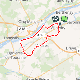
Randonnée A pied de 22 km à découvrir à Centre-Val de Loire, Indre-et-Loire, Villandry. Cette randonnée est proposée par fustier.
Description
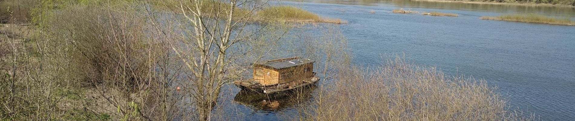
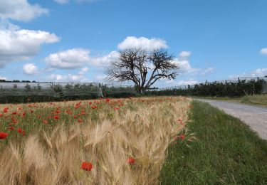
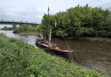
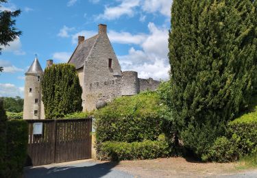
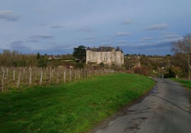
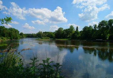
Beau parcours entre Cher, Loire et vergers.Passage devant le confluent du Cher et de la Loire. A voir le manoir de Fontenay classé monument historique. Sur le chemin voir La pierre au jonc (menhir) et bien sur le château de Villandry. Bonne promenade
Localisation
Pays :
France
Région :
Centre-Val de Loire
Département/Province :
Indre-et-Loire
Commune :
Villandry
Localité :
Unknown
Départ:(Dec)
Départ:(UTM)
312290 ; 5246143 (31T) N.
Commentaires
Randonnées à proximité
![Marche Marche](https://static1.geolcdn.com/sitytour/trail-icons/101.png)
Villandry - boucle bord du Cher puis GR3 - 4.9km 60m 1h15 - 2015 05 24
Marche
Facile
(1)
Villandry,
Centre-Val de Loire,
Indre-et-Loire,
France
![](/images/other/stat-length.png)
4,9 km | 5,7 km-effort
1h 15min
![](https://static1.geolcdn.com/siteimages/upload/files/16400158638029165_repeat_loop_refresh_sync_direction_icon.png)
Oui
![Randonnée Marche Vallères - Vallères le Hay - Zig zag Lignières-de-Touraine - 27.2km 300m 6h00 (50mn) - 2024 06 05 - Photo](https://media.geolcdn.com/t/375/260/b3324c15-4c92-4d98-acdf-5b4b32a3e010.jpg&format=jpg&maxdim=2)
![Marche Marche](https://static1.geolcdn.com/sitytour/trail-icons/101.png)
Vallères le Hay - Zig zag Lignières-de-Touraine - 27.2km 300m 6h00 (50mn) - 2...
Marche
Moyen
Vallères,
Centre-Val de Loire,
Indre-et-Loire,
France
![](/images/other/stat-length.png)
27 km | 31 km-effort
6h 0min
![](https://static1.geolcdn.com/siteimages/upload/files/16400158638029165_repeat_loop_refresh_sync_direction_icon.png)
Oui
![Randonnée Marche Savonnières - Savonnières - Zig zag Villandry - 20.7km 260m 4h25 (40mn) - 2024 06 02 - Photo](https://media.geolcdn.com/t/375/260/12f64fcc-4f3e-4220-83eb-fe5365015280.jpg&format=jpg&maxdim=2)
![Marche Marche](https://static1.geolcdn.com/sitytour/trail-icons/101.png)
Savonnières - Zig zag Villandry - 20.7km 260m 4h25 (40mn) - 2024 06 02
Marche
Facile
Savonnières,
Centre-Val de Loire,
Indre-et-Loire,
France
![](/images/other/stat-length.png)
21 km | 24 km-effort
4h 25min
![](https://static1.geolcdn.com/siteimages/upload/files/16400158638029165_repeat_loop_refresh_sync_direction_icon.png)
Oui
![Randonnée Marche Vallères - Vallères - Zig zag Manoir de Fontenay - 26.2km 350m 6h00 (35mn) - 2024 05 31 - Photo](https://media.geolcdn.com/t/375/260/2dd7bae2-e64d-4c31-aa25-080d87181237.jpg&format=jpg&maxdim=2)
![Marche Marche](https://static1.geolcdn.com/sitytour/trail-icons/101.png)
Vallères - Zig zag Manoir de Fontenay - 26.2km 350m 6h00 (35mn) - 2024 05 31
Marche
Facile
Vallères,
Centre-Val de Loire,
Indre-et-Loire,
France
![](/images/other/stat-length.png)
26 km | 31 km-effort
6h 0min
![](https://static1.geolcdn.com/siteimages/upload/files/16400158638029165_repeat_loop_refresh_sync_direction_icon.png)
Oui
![Randonnée Marche Saint-Étienne-de-Chigny - Saint-Étienne-de-Chigny - le Vieux Bourg - Luynes - 15.8km 285m 3h30 - 2024 02 28 - Photo](https://media.geolcdn.com/t/375/260/b6ad8ad7-2214-4d55-9cd7-2ee78c3b27ee.jpg&format=jpg&maxdim=2)
![Marche Marche](https://static1.geolcdn.com/sitytour/trail-icons/101.png)
Saint-Étienne-de-Chigny - le Vieux Bourg - Luynes - 15.8km 285m 3h30 - 2024 0...
Marche
Moyen
Saint-Étienne-de-Chigny,
Centre-Val de Loire,
Indre-et-Loire,
France
![](/images/other/stat-length.png)
15,8 km | 19,6 km-effort
3h 30min
![](https://static1.geolcdn.com/siteimages/upload/files/16400158638029165_repeat_loop_refresh_sync_direction_icon.png)
Oui
![Randonnée Marche Saint-Étienne-de-Chigny - Saint-Étienne-de-Chigny - la Pile de Cinq-Mars-la-Pile - 14.2km 215m 3h15 - 2024 02 17 - Photo](https://media.geolcdn.com/t/375/260/84d699f2-9fbc-4977-9839-f8db73d27f73.jpg&format=jpg&maxdim=2)
![Marche Marche](https://static1.geolcdn.com/sitytour/trail-icons/101.png)
Saint-Étienne-de-Chigny - la Pile de Cinq-Mars-la-Pile - 14.2km 215m 3h15 - 2...
Marche
Moyen
Saint-Étienne-de-Chigny,
Centre-Val de Loire,
Indre-et-Loire,
France
![](/images/other/stat-length.png)
14,5 km | 17,2 km-effort
3h 15min
![](https://static1.geolcdn.com/siteimages/upload/files/16400158638029165_repeat_loop_refresh_sync_direction_icon.png)
Oui
![Randonnée Marche Cinq-Mars-la-Pile - Cinq-Mars-la-Pile - Langeais - 14km 205m 3h05 - 2024 02 14 - Photo](https://media.geolcdn.com/t/375/260/bfe42b2e-405a-46df-8533-fbac70b0d338.jpg&format=jpg&maxdim=2)
![Marche Marche](https://static1.geolcdn.com/sitytour/trail-icons/101.png)
Cinq-Mars-la-Pile - Langeais - 14km 205m 3h05 - 2024 02 14
Marche
Facile
Cinq-Mars-la-Pile,
Centre-Val de Loire,
Indre-et-Loire,
France
![](/images/other/stat-length.png)
14 km | 16,7 km-effort
3h 5min
![](https://static1.geolcdn.com/siteimages/upload/files/16400158638029165_repeat_loop_refresh_sync_direction_icon.png)
Oui
![Randonnée Marche Savonnières - Savonnières - les Fontaines GR3 et PRs - 20.1km 190m 4h40 - 2022 05 12 - Photo](https://media.geolcdn.com/t/375/260/58a53b1f-8878-4695-8af8-d5fb36baa215.jpg&format=jpg&maxdim=2)
![Marche Marche](https://static1.geolcdn.com/sitytour/trail-icons/101.png)
Savonnières - les Fontaines GR3 et PRs - 20.1km 190m 4h40 - 2022 05 12
Marche
Facile
Savonnières,
Centre-Val de Loire,
Indre-et-Loire,
France
![](/images/other/stat-length.png)
20 km | 23 km-effort
4h 40min
![](https://static1.geolcdn.com/siteimages/upload/files/16400158638029165_repeat_loop_refresh_sync_direction_icon.png)
Oui
![Randonnée Marche Berthenay - Berthenay - Sentier des deux Eaux - 16.3km 65m 4h00 - 2022 05 08 - Photo](https://media.geolcdn.com/t/375/260/0ed1278a-60ca-4774-800b-77548f464139.jpg&format=jpg&maxdim=2)
![Marche Marche](https://static1.geolcdn.com/sitytour/trail-icons/101.png)
Berthenay - Sentier des deux Eaux - 16.3km 65m 4h00 - 2022 05 08
Marche
Facile
Berthenay,
Centre-Val de Loire,
Indre-et-Loire,
France
![](/images/other/stat-length.png)
16,3 km | 17,2 km-effort
4h 0min
![](https://static1.geolcdn.com/siteimages/upload/files/16400158638029165_repeat_loop_refresh_sync_direction_icon.png)
Oui