![](/images/other/stat-length.png)
![Randonnée Marche La Frette - RS-La-Frette-Villardière-et-Plantier - Photo](https://media.geolcdn.com/t/1900/400/ext.pjpeg?maxdim=2&url=https%3A%2F%2Fstatic1.geolcdn.com%2Fsiteimages%2Fupload%2Ffiles%2F1553511878bg_sport_marche.png)
RS-La-Frette-Villardière-et-Plantier
raymondfn
Utilisateur
![Longueur](/images/other/stat-length.png)
Longueur
5 km
![Altitude max](https://static1.geolcdn.com/siteimages/upload/files/1508320355ic_sort_altitude_max_24dp.png)
Altitude max
464 m
![Dénivelé positif](https://static1.geolcdn.com/siteimages/upload/files/1508320355ic_sort_den_pos_24dp.png)
Dénivelé positif
95 m
![Km-Effort](/images/other/stat-length.png)
Km-Effort
6,3 km
![Altitude min](https://static1.geolcdn.com/siteimages/upload/files/1508320355ic_sort_altitude_min_24dp.png)
Altitude min
414 m
![Dénivelé négatif](https://static1.geolcdn.com/siteimages/upload/files/1508320355ic_sort_den_neg_24dp.png)
Dénivelé négatif
97 m
![Boucle](https://static1.geolcdn.com/siteimages/upload/files/16400158638029165_repeat_loop_refresh_sync_direction_icon.png)
Boucle
Oui
Date de création :
2019-03-09 19:14:53.212
Dernière modification :
2022-01-20 16:26:34.086
![Marche](https://static1.geolcdn.com/sitytour/trail-icons/101.png)
1h13
Difficulté : Facile
![Scannez ce code QR pour ouvrir la randonnée dans l'application SityTrail](https://capi.geolives.com/qq0zvz2zws4bq2lad0pu/sitytour/trails/2045016/qr.png?size=200)
Application GPS de randonnée GRATUITE
À propos
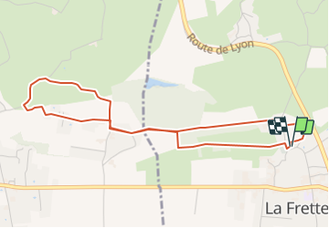
Randonnée Marche de 5 km à découvrir à Auvergne-Rhône-Alpes, Isère, La Frette. Cette randonnée est proposée par raymondfn.
Description
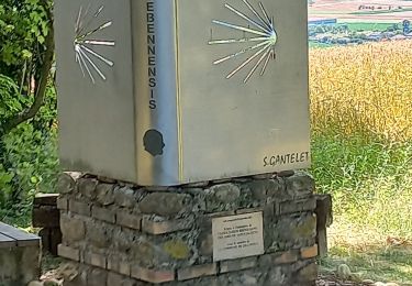
Petite balade depuis l'église de la Frette qui fait le tour du château de la Villardière et nous emmène jusqu'au hameau du Plantier (Saint-Hilaire-de-la-Côte), en empruntant le chemin de Compostelle.
Beaux panoramas sur la Bièvre, Chambaran, Chartreuse et Vercors.
Localisation
Pays :
France
Région :
Auvergne-Rhône-Alpes
Département/Province :
Isère
Commune :
La Frette
Localité :
Unknown
Départ:(Dec)
Départ:(UTM)
684578 ; 5029325 (31T) N.
Commentaires
Randonnées à proximité
![Randonnée Marche Bévenais - téléthon Bévenais - Photo](https://media.geolcdn.com/t/375/260/ext.jpg?maxdim=2&url=https%3A%2F%2Fstatic1.geolcdn.com%2Fsiteimages%2Fupload%2Ffiles%2F1553511878bg_sport_marche.png)
![Marche Marche](https://static1.geolcdn.com/sitytour/trail-icons/101.png)
téléthon Bévenais
Marche
Difficile
(1)
Bévenais,
Auvergne-Rhône-Alpes,
Isère,
France
![](/images/other/stat-length.png)
12 km | 17,6 km-effort
4h 9min
![](https://static1.geolcdn.com/siteimages/upload/files/16400158638029165_repeat_loop_refresh_sync_direction_icon.png)
Oui
![Randonnée Marche Saint-Hilaire-de-la-Côte - RS-Côteau des épées - Photo](https://media.geolcdn.com/t/375/260/ext.jpg?maxdim=2&url=https%3A%2F%2Fstatic1.geolcdn.com%2Fsiteimages%2Fupload%2Ffiles%2F1553511878bg_sport_marche.png)
![Marche Marche](https://static1.geolcdn.com/sitytour/trail-icons/101.png)
RS-Côteau des épées
Marche
Facile
(1)
Saint-Hilaire-de-la-Côte,
Auvergne-Rhône-Alpes,
Isère,
France
![](/images/other/stat-length.png)
4,5 km | 5,1 km-effort
1h 9min
![](https://static1.geolcdn.com/siteimages/upload/files/16400158638029165_repeat_loop_refresh_sync_direction_icon.png)
Oui
![Randonnée Marche Longechenal - Bellindron - Photo](https://media.geolcdn.com/t/375/260/ext.jpg?maxdim=2&url=https%3A%2F%2Fstatic1.geolcdn.com%2Fsiteimages%2Fupload%2Ffiles%2F1553511878bg_sport_marche.png)
![Marche Marche](https://static1.geolcdn.com/sitytour/trail-icons/101.png)
Bellindron
Marche
Facile
(1)
Longechenal,
Auvergne-Rhône-Alpes,
Isère,
France
![](/images/other/stat-length.png)
10,7 km | 13,9 km-effort
3h 0min
![](https://static1.geolcdn.com/siteimages/upload/files/16400158638029165_repeat_loop_refresh_sync_direction_icon.png)
Oui
![Randonnée Marche Saint-Hilaire-de-la-Côte - Bocsozel sentier medieval - Photo](https://media.geolcdn.com/t/375/260/91cbdc1b-8001-4f03-93a9-7d4d5430fde2.jpg&format=jpg&maxdim=2)
![Marche Marche](https://static1.geolcdn.com/sitytour/trail-icons/101.png)
Bocsozel sentier medieval
Marche
Moyen
Saint-Hilaire-de-la-Côte,
Auvergne-Rhône-Alpes,
Isère,
France
![](/images/other/stat-length.png)
13,1 km | 18,6 km-effort
6h 17min
![](https://static1.geolcdn.com/siteimages/upload/files/16400158638029165_repeat_loop_refresh_sync_direction_icon.png)
Oui
![Randonnée Marche Bévenais - RD-Le-Grand-Lemps-Bevenais - Photo](https://media.geolcdn.com/t/375/260/ext.jpg?maxdim=2&url=https%3A%2F%2Fstatic1.geolcdn.com%2Fsiteimages%2Fupload%2Ffiles%2F1553511878bg_sport_marche.png)
![Marche Marche](https://static1.geolcdn.com/sitytour/trail-icons/101.png)
RD-Le-Grand-Lemps-Bevenais
Marche
Moyen
(1)
Bévenais,
Auvergne-Rhône-Alpes,
Isère,
France
![](/images/other/stat-length.png)
8,6 km | 10,4 km-effort
2h 22min
![](https://static1.geolcdn.com/siteimages/upload/files/16400158638029165_repeat_loop_refresh_sync_direction_icon.png)
Oui
![Randonnée Marche Saint-Hilaire-de-la-Côte - RS-St-Hillaire-de-la-Côte-Fournache - Photo](https://media.geolcdn.com/t/375/260/ext.jpg?maxdim=2&url=https%3A%2F%2Fstatic1.geolcdn.com%2Fsiteimages%2Fupload%2Ffiles%2F1553511878bg_sport_marche.png)
![Marche Marche](https://static1.geolcdn.com/sitytour/trail-icons/101.png)
RS-St-Hillaire-de-la-Côte-Fournache
Marche
Moyen
(1)
Saint-Hilaire-de-la-Côte,
Auvergne-Rhône-Alpes,
Isère,
France
![](/images/other/stat-length.png)
5,2 km | 6,1 km-effort
1h 23min
![](https://static1.geolcdn.com/siteimages/upload/files/16400158638029165_repeat_loop_refresh_sync_direction_icon.png)
Oui
![Randonnée Marche Longechenal - lonchenal - Photo](https://media.geolcdn.com/t/375/260/f6d5cb5f-e7ca-466b-bee6-ea95851425a2.jpg&format=jpg&maxdim=2)
![Marche Marche](https://static1.geolcdn.com/sitytour/trail-icons/101.png)
lonchenal
Marche
Très facile
Longechenal,
Auvergne-Rhône-Alpes,
Isère,
France
![](/images/other/stat-length.png)
8,1 km | 11,1 km-effort
2h 47min
![](https://static1.geolcdn.com/siteimages/upload/files/16400158638029165_repeat_loop_refresh_sync_direction_icon.png)
Non
![Randonnée Marche La Frette - Le Marais et le Château de La Frette - Photo](https://media.geolcdn.com/t/375/260/ext.jpg?maxdim=2&url=https%3A%2F%2Fstatic1.geolcdn.com%2Fsiteimages%2Fupload%2Ffiles%2F1553511878bg_sport_marche.png)
![Marche Marche](https://static1.geolcdn.com/sitytour/trail-icons/101.png)
Le Marais et le Château de La Frette
Marche
Moyen
(1)
La Frette,
Auvergne-Rhône-Alpes,
Isère,
France
![](/images/other/stat-length.png)
8,1 km | 9,6 km-effort
2h 5min
![](https://static1.geolcdn.com/siteimages/upload/files/16400158638029165_repeat_loop_refresh_sync_direction_icon.png)
Oui
![Randonnée Marche Longechenal - longechenal 2 - Photo](https://media.geolcdn.com/t/375/260/f094b42a-2ba4-4ceb-b6ef-4e22d113281d.jpg&format=jpg&maxdim=2)
![Marche Marche](https://static1.geolcdn.com/sitytour/trail-icons/101.png)
longechenal 2
Marche
Facile
Longechenal,
Auvergne-Rhône-Alpes,
Isère,
France
![](/images/other/stat-length.png)
9,7 km | 12,8 km-effort
2h 25min
![](https://static1.geolcdn.com/siteimages/upload/files/16400158638029165_repeat_loop_refresh_sync_direction_icon.png)
Oui