![](/images/other/stat-length.png)
![Randonnée Marche Sanilhac - ND de Sanilhac-Boucle de la Pierre Grise - Photo](https://media.geolcdn.com/t/1900/400/ext.pjpeg?maxdim=2&url=https%3A%2F%2Fstatic1.geolcdn.com%2Fsiteimages%2Fupload%2Ffiles%2F1553511878bg_sport_marche.png)
ND de Sanilhac-Boucle de la Pierre Grise
sidore
Utilisateur
![Longueur](/images/other/stat-length.png)
Longueur
9,1 km
![Altitude max](https://static1.geolcdn.com/siteimages/upload/files/1508320355ic_sort_altitude_max_24dp.png)
Altitude max
239 m
![Dénivelé positif](https://static1.geolcdn.com/siteimages/upload/files/1508320355ic_sort_den_pos_24dp.png)
Dénivelé positif
179 m
![Km-Effort](/images/other/stat-length.png)
Km-Effort
11,5 km
![Altitude min](https://static1.geolcdn.com/siteimages/upload/files/1508320355ic_sort_altitude_min_24dp.png)
Altitude min
147 m
![Dénivelé négatif](https://static1.geolcdn.com/siteimages/upload/files/1508320355ic_sort_den_neg_24dp.png)
Dénivelé négatif
179 m
![Boucle](https://static1.geolcdn.com/siteimages/upload/files/16400158638029165_repeat_loop_refresh_sync_direction_icon.png)
Boucle
Oui
Date de création :
2019-03-03 14:25:25.828
Dernière modification :
2019-03-03 17:06:54.879
![Marche](https://static1.geolcdn.com/sitytour/trail-icons/101.png)
1h48
Difficulté : Moyen
![Scannez ce code QR pour ouvrir la randonnée dans l'application SityTrail](https://capi.geolives.com/qq0zvz2zws4bq2lad0pu/sitytour/trails/2042126/qr.png?size=200)
Application GPS de randonnée GRATUITE
À propos
Randonnée Marche de 9,1 km à découvrir à Nouvelle-Aquitaine, Dordogne, Sanilhac. Cette randonnée est proposée par sidore.
Description
A la sortie du bois, avant le lieu-dit Champs un chien devant la maison sur la droite, qui a priori ne peut pas sortir grâce à un fil enterré.
Localisation
Pays :
France
Région :
Nouvelle-Aquitaine
Département/Province :
Dordogne
Commune :
Sanilhac
Localité :
Notre-Dame-de-Sanilhac
Départ:(Dec)
Départ:(UTM)
321028 ; 4998325 (31T) N.
Commentaires
Randonnées à proximité
![Randonnée Marche Boulazac Isle Manoire - Atur - Photo](https://media.geolcdn.com/t/375/260/ext.jpg?maxdim=2&url=https%3A%2F%2Fstatic1.geolcdn.com%2Fsiteimages%2Fupload%2Ffiles%2F1553511878bg_sport_marche.png)
![Marche Marche](https://static1.geolcdn.com/sitytour/trail-icons/101.png)
Atur
Marche
Facile
(1)
Boulazac Isle Manoire,
Nouvelle-Aquitaine,
Dordogne,
France
![](/images/other/stat-length.png)
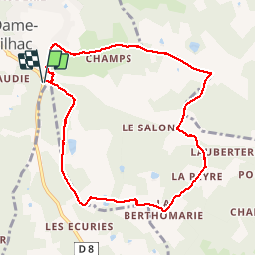
12,5 km | 15,8 km-effort
3h 23min
![](https://static1.geolcdn.com/siteimages/upload/files/16400158638029165_repeat_loop_refresh_sync_direction_icon.png)
Oui
![Randonnée Marche Sanilhac - Marsaneix - Photo](https://media.geolcdn.com/t/375/260/ext.jpg?maxdim=2&url=https%3A%2F%2Fstatic1.geolcdn.com%2Fsiteimages%2Fupload%2Ffiles%2F1553511878bg_sport_marche.png)
![Marche Marche](https://static1.geolcdn.com/sitytour/trail-icons/101.png)
Marsaneix
Marche
Facile
(1)
Sanilhac,
Nouvelle-Aquitaine,
Dordogne,
France
![](/images/other/stat-length.png)
14,8 km | 17,9 km-effort
3h 35min
![](https://static1.geolcdn.com/siteimages/upload/files/16400158638029165_repeat_loop_refresh_sync_direction_icon.png)
Oui
![Randonnée Marche Sanilhac - ND de Sanilhac-Boucle du Pic - Photo](https://media.geolcdn.com/t/375/260/ext.jpg?maxdim=2&url=https%3A%2F%2Fstatic1.geolcdn.com%2Fsiteimages%2Fupload%2Ffiles%2F1553511878bg_sport_marche.png)
![Marche Marche](https://static1.geolcdn.com/sitytour/trail-icons/101.png)
ND de Sanilhac-Boucle du Pic
Marche
Facile
(2)
Sanilhac,
Nouvelle-Aquitaine,
Dordogne,
France
![](/images/other/stat-length.png)
7,3 km | 9 km-effort
1h 43min
![](https://static1.geolcdn.com/siteimages/upload/files/16400158638029165_repeat_loop_refresh_sync_direction_icon.png)
Oui
![Randonnée Marche Église-Neuve-de-Vergt - Eglise Neuve Vergt - Photo](https://media.geolcdn.com/t/375/260/c1219e7f-9e9a-411f-9248-f2ee6d3c3c64.jpg&format=jpg&maxdim=2)
![Marche Marche](https://static1.geolcdn.com/sitytour/trail-icons/101.png)
Eglise Neuve Vergt
Marche
Facile
Église-Neuve-de-Vergt,
Nouvelle-Aquitaine,
Dordogne,
France
![](/images/other/stat-length.png)
11,5 km | 14,3 km-effort
2h 36min
![](https://static1.geolcdn.com/siteimages/upload/files/16400158638029165_repeat_loop_refresh_sync_direction_icon.png)
Oui
![Randonnée Marche Creyssensac-et-Pissot - boucle creyssensac - Photo](https://media.geolcdn.com/t/375/260/ext.jpg?maxdim=2&url=https%3A%2F%2Fservices.sitytrail.com%2FGeolivesWS%2FDownloadMedia.ashx%3FTrailID%3D921085%26Media%3Dfix__20180311164914.jpg)
![Marche Marche](https://static1.geolcdn.com/sitytour/trail-icons/101.png)
boucle creyssensac
Marche
Facile
Creyssensac-et-Pissot,
Nouvelle-Aquitaine,
Dordogne,
France
![](/images/other/stat-length.png)
10,2 km | 12,7 km-effort
2h 14min
![](https://static1.geolcdn.com/siteimages/upload/files/16400158638029165_repeat_loop_refresh_sync_direction_icon.png)
Oui
![Randonnée Marche Sanilhac - Boucle du puits trouillier - Notre-Dame-de-Sanilhac - Photo](https://media.geolcdn.com/t/375/260/ext.jpg?maxdim=2&url=https%3A%2F%2Fservices.sitytrail.com%2FGeolivesWS%2FDownloadMedia.ashx%3FTrailID%3D316973%26Media%3D16096_1.jpg)
![Marche Marche](https://static1.geolcdn.com/sitytour/trail-icons/101.png)
Boucle du puits trouillier - Notre-Dame-de-Sanilhac
Marche
Moyen
Sanilhac,
Nouvelle-Aquitaine,
Dordogne,
France
![](/images/other/stat-length.png)
8,2 km | 10,6 km-effort
2h 0min
![](https://static1.geolcdn.com/siteimages/upload/files/16400158638029165_repeat_loop_refresh_sync_direction_icon.png)
Oui
![Randonnée Marche Sanilhac - Notre Dame de Sanilhac ( longue) - Photo](https://media.geolcdn.com/t/375/260/ext.jpg?maxdim=2&url=https%3A%2F%2Fstatic1.geolcdn.com%2Fsiteimages%2Fupload%2Ffiles%2F1553511878bg_sport_marche.png)
![Marche Marche](https://static1.geolcdn.com/sitytour/trail-icons/101.png)
Notre Dame de Sanilhac ( longue)
Marche
Moyen
Sanilhac,
Nouvelle-Aquitaine,
Dordogne,
France
![](/images/other/stat-length.png)
11,8 km | 15,1 km-effort
3h 14min
![](https://static1.geolcdn.com/siteimages/upload/files/16400158638029165_repeat_loop_refresh_sync_direction_icon.png)
Oui
![Randonnée Marche Coulounieix-Chamiers - boucle coulounieix - Photo](https://media.geolcdn.com/t/375/260/ext.jpg?maxdim=2&url=https%3A%2F%2Fstatic1.geolcdn.com%2Fsiteimages%2Fupload%2Ffiles%2F1553511878bg_sport_marche.png)
![Marche Marche](https://static1.geolcdn.com/sitytour/trail-icons/101.png)
boucle coulounieix
Marche
Facile
(1)
Coulounieix-Chamiers,
Nouvelle-Aquitaine,
Dordogne,
France
![](/images/other/stat-length.png)
12,7 km | 16,4 km-effort
2h 50min
![](https://static1.geolcdn.com/siteimages/upload/files/16400158638029165_repeat_loop_refresh_sync_direction_icon.png)
Oui
![Randonnée A pied Chalagnac - Boucle du Bas-Combin - Photo](https://media.geolcdn.com/t/375/260/ext.jpg?maxdim=2&url=https%3A%2F%2Fstatic1.geolcdn.com%2Fsiteimages%2Fupload%2Ffiles%2F1545311037marcheuse_200dpi.jpg)
![A pied A pied](https://static1.geolcdn.com/sitytour/trail-icons/100.png)
Boucle du Bas-Combin
A pied
Facile
Chalagnac,
Nouvelle-Aquitaine,
Dordogne,
France
![](/images/other/stat-length.png)
6,8 km | 9,1 km-effort
2h 4min
![](https://static1.geolcdn.com/siteimages/upload/files/16400158638029165_repeat_loop_refresh_sync_direction_icon.png)
Oui