![](/images/other/stat-length.png)
![Randonnée Marche Évenos - Le Mont CAUME - Photo](https://media.geolcdn.com/t/1900/400/da467cc3-df6b-463b-8b92-dc7ade887d2a.jpg&format=pjpeg&maxdim=2)
Le Mont CAUME
SabetMick
Utilisateur
![Longueur](/images/other/stat-length.png)
Longueur
8,4 km
![Altitude max](https://static1.geolcdn.com/siteimages/upload/files/1508320355ic_sort_altitude_max_24dp.png)
Altitude max
788 m
![Dénivelé positif](https://static1.geolcdn.com/siteimages/upload/files/1508320355ic_sort_den_pos_24dp.png)
Dénivelé positif
394 m
![Km-Effort](/images/other/stat-length.png)
Km-Effort
13,6 km
![Altitude min](https://static1.geolcdn.com/siteimages/upload/files/1508320355ic_sort_altitude_min_24dp.png)
Altitude min
390 m
![Dénivelé négatif](https://static1.geolcdn.com/siteimages/upload/files/1508320355ic_sort_den_neg_24dp.png)
Dénivelé négatif
400 m
![Boucle](https://static1.geolcdn.com/siteimages/upload/files/16400158638029165_repeat_loop_refresh_sync_direction_icon.png)
Boucle
Oui
Date de création :
2019-03-01 15:38:21.473
Dernière modification :
2019-03-01 18:09:01.811
![Marche](https://static1.geolcdn.com/sitytour/trail-icons/101.png)
2h15
Difficulté : Très facile
![Scannez ce code QR pour ouvrir la randonnée dans l'application SityTrail](https://capi.geolives.com/qq0zvz2zws4bq2lad0pu/sitytour/trails/2041272/qr.png?size=200)
Application GPS de randonnée GRATUITE
À propos
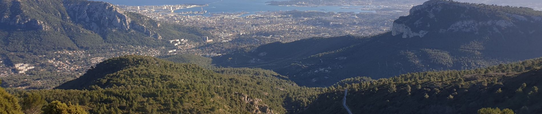
Randonnée Marche de 8,4 km à découvrir à Provence-Alpes-Côte d'Azur, Var, Évenos. Cette randonnée est proposée par SabetMick.
Description
Jolie ballade qui offre de superbes vues sur la rade de Toulon, le Mont Faron et plus encore. Le retour se fait par la route, mais la vue superbe nous le fait assez vite oublier. Magnifique panorama depuis le sommet du mont Caume.
Localisation
Pays :
France
Région :
Provence-Alpes-Côte d'Azur
Département/Province :
Var
Commune :
Évenos
Localité :
Unknown
Départ:(Dec)
Départ:(UTM)
734753 ; 4783813 (31T) N.
Commentaires
Randonnées à proximité
![Randonnée Marche Ollioules - Chateau Vallon - Oppidum - Meulerie - Grotte patrimoine - vallon du Destel - Grotte des Joncs 9 - Four à cade - Appier - Four à chaux - Photo](https://media.geolcdn.com/t/375/260/b00c002a-3425-4f84-ae24-7620ef9e7315.jpg&format=jpg&maxdim=2)
![Marche Marche](https://static1.geolcdn.com/sitytour/trail-icons/101.png)
Chateau Vallon - Oppidum - Meulerie - Grotte patrimoine - vallon du Destel - ...
Marche
Moyen
(1)
Ollioules,
Provence-Alpes-Côte d'Azur,
Var,
France
![](/images/other/stat-length.png)
11,8 km | 19,3 km-effort
4h 23min
![](https://static1.geolcdn.com/siteimages/upload/files/16400158638029165_repeat_loop_refresh_sync_direction_icon.png)
Oui
![Randonnée Marche Évenos - Autour de St Anne d'Evenos. - Photo](https://media.geolcdn.com/t/375/260/1a61a6ef-600e-4900-ae4e-54737b695f44.jpg&format=jpg&maxdim=2)
![Marche Marche](https://static1.geolcdn.com/sitytour/trail-icons/101.png)
Autour de St Anne d'Evenos.
Marche
Difficile
(1)
Évenos,
Provence-Alpes-Côte d'Azur,
Var,
France
![](/images/other/stat-length.png)
13 km | 18,7 km-effort
4h 15min
![](https://static1.geolcdn.com/siteimages/upload/files/16400158638029165_repeat_loop_refresh_sync_direction_icon.png)
Oui
![Randonnée Marche Le Revest-les-Eaux - Boucle: La ripelle - Source de la ripelle - Le Chateau de Tourris - Les grottes de sable - La carrière aux fourmis - Les puits renovés de M. Lambicchi - Les ruines des Olivières - La ferme de la Touravelle - à Le Revest-les-Eaux - Photo](https://media.geolcdn.com/t/375/260/0dbff04b-2a84-4eed-a6e8-7a56bc074382.jpg&format=jpg&maxdim=2)
![Marche Marche](https://static1.geolcdn.com/sitytour/trail-icons/101.png)
Boucle: La ripelle - Source de la ripelle - Le Chateau de Tourris - Les grott...
Marche
Moyen
(1)
Le Revest-les-Eaux,
Provence-Alpes-Côte d'Azur,
Var,
France
![](/images/other/stat-length.png)
14,1 km | 21 km-effort
4h 15min
![](https://static1.geolcdn.com/siteimages/upload/files/16400158638029165_repeat_loop_refresh_sync_direction_icon.png)
Oui
![Randonnée Marche Toulon - Faron côté nord - Photo](https://media.geolcdn.com/t/375/260/1a97f987-c174-4fc8-a435-d00586c57288.jpg&format=jpg&maxdim=2)
![Marche Marche](https://static1.geolcdn.com/sitytour/trail-icons/101.png)
Faron côté nord
Marche
Difficile
(1)
Toulon,
Provence-Alpes-Côte d'Azur,
Var,
France
![](/images/other/stat-length.png)
4,6 km | 10,1 km-effort
3h 8min
![](https://static1.geolcdn.com/siteimages/upload/files/16400158638029165_repeat_loop_refresh_sync_direction_icon.png)
Non
![Randonnée Marche Le Revest-les-Eaux - 83 barrage revest les eaux 24-05-2021 - Photo](https://media.geolcdn.com/t/375/260/1106c6f7-fedf-4077-96a1-b48580038b53.jpg&format=jpg&maxdim=2)
![Marche Marche](https://static1.geolcdn.com/sitytour/trail-icons/101.png)
83 barrage revest les eaux 24-05-2021
Marche
Moyen
(1)
Le Revest-les-Eaux,
Provence-Alpes-Côte d'Azur,
Var,
France
![](/images/other/stat-length.png)
8 km | 12,3 km-effort
3h 41min
![](https://static1.geolcdn.com/siteimages/upload/files/16400158638029165_repeat_loop_refresh_sync_direction_icon.png)
Oui
![Randonnée Marche Toulon - Tour Du Baou par falaises - Photo](https://media.geolcdn.com/t/375/260/ext.jpg?maxdim=2&url=https%3A%2F%2Fservices.sitytrail.com%2FGeolivesWS%2FDownloadMedia.ashx%3FTrailID%3D166161%26Media%3D20121215151840.jpeg)
![Marche Marche](https://static1.geolcdn.com/sitytour/trail-icons/101.png)
Tour Du Baou par falaises
Marche
Moyen
(1)
Toulon,
Provence-Alpes-Côte d'Azur,
Var,
France
![](/images/other/stat-length.png)
7,3 km | 11,3 km-effort
2h 10min
![](https://static1.geolcdn.com/siteimages/upload/files/16400158638029165_repeat_loop_refresh_sync_direction_icon.png)
Oui
![Randonnée Marche Évenos - Le broussan croupatier fin randonnée - Photo](https://media.geolcdn.com/t/375/260/ec3fd25e-452d-47c7-8bcf-accd29bcb68e.jpg&format=jpg&maxdim=2)
![Marche Marche](https://static1.geolcdn.com/sitytour/trail-icons/101.png)
Le broussan croupatier fin randonnée
Marche
Moyen
(3)
Évenos,
Provence-Alpes-Côte d'Azur,
Var,
France
![](/images/other/stat-length.png)
10,6 km | 14,9 km-effort
5h 18min
![](https://static1.geolcdn.com/siteimages/upload/files/16400158638029165_repeat_loop_refresh_sync_direction_icon.png)
Oui
![Randonnée Marche Le Revest-les-Eaux - Boucle: Ripelle - Touravelle - Ruines des olivieres - Carrière aux fourmis - Grottes de sables - Vieille valette - Tourris - Source - Ripelle - Photo](https://media.geolcdn.com/t/375/260/ext.jpg?maxdim=2&url=https%3A%2F%2Fstatic1.geolcdn.com%2Fsiteimages%2Fupload%2Ffiles%2F1553511878bg_sport_marche.png)
![Marche Marche](https://static1.geolcdn.com/sitytour/trail-icons/101.png)
Boucle: Ripelle - Touravelle - Ruines des olivieres - Carrière aux fourmis ...
Marche
Moyen
(1)
Le Revest-les-Eaux,
Provence-Alpes-Côte d'Azur,
Var,
France
![](/images/other/stat-length.png)
13,4 km | 19,4 km-effort
5h 0min
![](https://static1.geolcdn.com/siteimages/upload/files/16400158638029165_repeat_loop_refresh_sync_direction_icon.png)
Oui
![Randonnée Marche Évenos - Sainte Anne d'Evenos Le Gros Cerveau - Photo](https://media.geolcdn.com/t/375/260/ext.jpg?maxdim=2&url=https%3A%2F%2Fservices.sitytrail.com%2FGeolivesWS%2FDownloadMedia.ashx%3FTrailID%3D104105%26Media%3D7169_2.jpg)
![Marche Marche](https://static1.geolcdn.com/sitytour/trail-icons/101.png)
Sainte Anne d'Evenos Le Gros Cerveau
Marche
Difficile
(3)
Évenos,
Provence-Alpes-Côte d'Azur,
Var,
France
![](/images/other/stat-length.png)
7 km | 11,8 km-effort
3h 30min
![](https://static1.geolcdn.com/siteimages/upload/files/16400158638029165_repeat_loop_refresh_sync_direction_icon.png)
Oui