![](/images/other/stat-length.png)
![Randonnée Marche Baelen - rando fagne1: Eupen-Ovifat - Photo](https://media.geolcdn.com/t/1900/400/ext.pjpeg?maxdim=2&url=https%3A%2F%2Fstatic1.geolcdn.com%2Fsiteimages%2Fupload%2Ffiles%2F1553511878bg_sport_marche.png)
rando fagne1: Eupen-Ovifat
natacha.brion69
Utilisateur
![Longueur](/images/other/stat-length.png)
Longueur
23 km
![Altitude max](https://static1.geolcdn.com/siteimages/upload/files/1508320355ic_sort_altitude_max_24dp.png)
Altitude max
660 m
![Dénivelé positif](https://static1.geolcdn.com/siteimages/upload/files/1508320355ic_sort_den_pos_24dp.png)
Dénivelé positif
521 m
![Km-Effort](/images/other/stat-length.png)
Km-Effort
29 km
![Altitude min](https://static1.geolcdn.com/siteimages/upload/files/1508320355ic_sort_altitude_min_24dp.png)
Altitude min
296 m
![Dénivelé négatif](https://static1.geolcdn.com/siteimages/upload/files/1508320355ic_sort_den_neg_24dp.png)
Dénivelé négatif
221 m
![Boucle](https://static1.geolcdn.com/siteimages/upload/files/16400158638029165_repeat_loop_refresh_sync_direction_icon.png)
Boucle
Non
Date de création :
2019-02-27 11:33:05.673
Dernière modification :
2019-02-27 12:51:30.816
![Marche](https://static1.geolcdn.com/sitytour/trail-icons/101.png)
8h00
Difficulté : Moyen
![Scannez ce code QR pour ouvrir la randonnée dans l'application SityTrail](https://capi.geolives.com/qq0zvz2zws4bq2lad0pu/sitytour/trails/2040359/qr.png?size=200)
Application GPS de randonnée GRATUITE
À propos
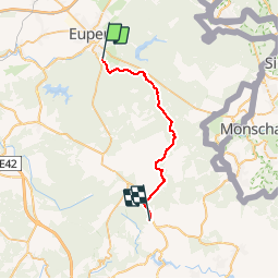
Randonnée Marche de 23 km à découvrir à Wallonie, Liège, Baelen. Cette randonnée est proposée par natacha.brion69.
Description
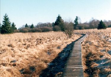
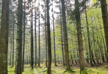
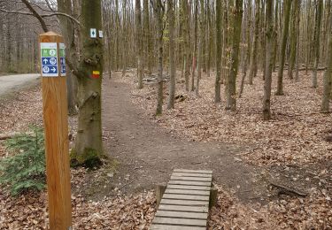
Suis pour une grande partie le tracé du GR 573.
Au départ: arret bus TEC (depuis la gare routière d'Eupen)
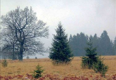
A l'arrivée: gites d'étape d'Ovifat
Suite: rando fagne2: Ovifat-Malmedy
Localisation
Pays :
Belgique
Région :
Wallonie
Département/Province :
Liège
Commune :
Baelen
Localité :
Membach
Départ:(Dec)
Départ:(UTM)
291173 ; 5610606 (32U) N.
Commentaires
Randonnées à proximité
![Randonnée Marche Eupen - RB-Lg-05_Barrage-d'Eupen - Photo](https://media.geolcdn.com/t/375/260/ext.jpg?maxdim=2&url=https%3A%2F%2Fservices.sitytrail.com%2FGeolivesWS%2FDownloadMedia.ashx%3FTrailID%3D179562%26Media%3D7980f674-60b2-4319-848f-6714eb887ad5.jpg)
![Marche Marche](https://static1.geolcdn.com/sitytour/trail-icons/101.png)
RB-Lg-05_Barrage-d'Eupen
Marche
Très difficile
(11)
Eupen,
Wallonie,
Liège,
Belgique
![](/images/other/stat-length.png)
21 km | 26 km-effort
5h 49min
![](https://static1.geolcdn.com/siteimages/upload/files/16400158638029165_repeat_loop_refresh_sync_direction_icon.png)
Oui
![Randonnée Marche Eupen - Barrage d'Eupen - Photo](https://media.geolcdn.com/t/375/260/90a093c8-ca4c-4f2d-8dba-28de0ca9565e.jpg&format=jpg&maxdim=2)
![Marche Marche](https://static1.geolcdn.com/sitytour/trail-icons/101.png)
Barrage d'Eupen
Marche
Moyen
(1)
Eupen,
Wallonie,
Liège,
Belgique
![](/images/other/stat-length.png)
12 km | 14,4 km-effort
3h 16min
![](https://static1.geolcdn.com/siteimages/upload/files/16400158638029165_repeat_loop_refresh_sync_direction_icon.png)
Oui
![Randonnée Marche Eupen - Autour d'Eupen - Photo](https://media.geolcdn.com/t/375/260/2e56e8e4-4348-489f-86b5-c8ca8af64230.jpg&format=jpg&maxdim=2)
![Marche Marche](https://static1.geolcdn.com/sitytour/trail-icons/101.png)
Autour d'Eupen
Marche
Facile
(1)
Eupen,
Wallonie,
Liège,
Belgique
![](/images/other/stat-length.png)
13,3 km | 16,4 km-effort
3h 43min
![](https://static1.geolcdn.com/siteimages/upload/files/16400158638029165_repeat_loop_refresh_sync_direction_icon.png)
Oui
![Randonnée Marche Eupen - Barrage d'Eupen - Photo](https://media.geolcdn.com/t/375/260/aecf99e8-444d-43fd-940e-03b123a2fe72.jpg&format=jpg&maxdim=2)
![Marche Marche](https://static1.geolcdn.com/sitytour/trail-icons/101.png)
Barrage d'Eupen
Marche
Facile
(1)
Eupen,
Wallonie,
Liège,
Belgique
![](/images/other/stat-length.png)
14,2 km | 17,1 km-effort
3h 53min
![](https://static1.geolcdn.com/siteimages/upload/files/16400158638029165_repeat_loop_refresh_sync_direction_icon.png)
Oui
![Randonnée Marche Eupen - Eupen - Photo](https://media.geolcdn.com/t/375/260/d87483d2-4d3d-461a-a9c9-ec45b2516003.jpg&format=jpg&maxdim=2)
![Marche Marche](https://static1.geolcdn.com/sitytour/trail-icons/101.png)
![Randonnée Marche Baelen - La Montagne du Dragon - Photo](https://media.geolcdn.com/t/375/260/3a1bc634-7bf5-4748-bbb3-513b265a48b5.jpg&format=jpg&maxdim=2)
![Marche Marche](https://static1.geolcdn.com/sitytour/trail-icons/101.png)
La Montagne du Dragon
Marche
Facile
(1)
Baelen,
Wallonie,
Liège,
Belgique
![](/images/other/stat-length.png)
16,2 km | 21 km-effort
3h 21min
![](https://static1.geolcdn.com/siteimages/upload/files/16400158638029165_repeat_loop_refresh_sync_direction_icon.png)
Oui
![Randonnée Marche Baelen - Hestreux - Circuit Natura 2000 - Lg 23 - Photo](https://media.geolcdn.com/t/375/260/ext.jpg?maxdim=2&url=https%3A%2F%2Fservices.sitytrail.com%2FGeolivesWS%2FDownloadMedia.ashx%3FTrailID%3D543693%26Media%3Db6dc624c-a5db-4eb7-8557-25b4defb2280.JPG)
![Marche Marche](https://static1.geolcdn.com/sitytour/trail-icons/101.png)
Hestreux - Circuit Natura 2000 - Lg 23
Marche
Facile
(4)
Baelen,
Wallonie,
Liège,
Belgique
![](/images/other/stat-length.png)
8,6 km | 10,3 km-effort
3h 0min
![](https://static1.geolcdn.com/siteimages/upload/files/16400158638029165_repeat_loop_refresh_sync_direction_icon.png)
Non
![Randonnée Marche Eupen - RB-Lg-05_Barrage-d'Eupen_via-raccourci - Photo](https://media.geolcdn.com/t/375/260/ext.jpg?maxdim=2&url=https%3A%2F%2Fservices.sitytrail.com%2FGeolivesWS%2FDownloadMedia.ashx%3FTrailID%3D209405%26Media%3D2f0b60af-bd30-4227-95f2-7ed80e415229.jpg)
![Marche Marche](https://static1.geolcdn.com/sitytour/trail-icons/101.png)
RB-Lg-05_Barrage-d'Eupen_via-raccourci
Marche
Très difficile
(1)
Eupen,
Wallonie,
Liège,
Belgique
![](/images/other/stat-length.png)
18,5 km | 22 km-effort
5h 6min
![](https://static1.geolcdn.com/siteimages/upload/files/16400158638029165_repeat_loop_refresh_sync_direction_icon.png)
Oui
![Randonnée Marche Eupen - Eupen, par bois, prairies et chemins - Photo](https://media.geolcdn.com/t/375/260/ext.jpg?maxdim=2&url=https%3A%2F%2Fservices.sitytrail.com%2FGeolivesWS%2FDownloadMedia.ashx%3FTrailID%3D757615%26Media%3D20170521143224.jpg)
![Marche Marche](https://static1.geolcdn.com/sitytour/trail-icons/101.png)
Eupen, par bois, prairies et chemins
Marche
Facile
(1)
Eupen,
Wallonie,
Liège,
Belgique
![](/images/other/stat-length.png)
12,8 km | 15,5 km-effort
3h 24min
![](https://static1.geolcdn.com/siteimages/upload/files/16400158638029165_repeat_loop_refresh_sync_direction_icon.png)
Oui