![](/images/other/stat-length.png)
![Randonnée Vélo électrique Renaix - Renaix - Louise Marie (chemins boisés) - Photo](https://media.geolcdn.com/t/1900/400/4847782f-e6a6-4af4-837e-c81f48775427.jpg&format=pjpeg&maxdim=2)
Renaix - Louise Marie (chemins boisés)
bve9600
Utilisateur
![Longueur](/images/other/stat-length.png)
Longueur
16,2 km
![Boucle](https://static1.geolcdn.com/siteimages/upload/files/16400158638029165_repeat_loop_refresh_sync_direction_icon.png)
Boucle
Oui
Date de création :
2019-02-24 11:24:59.53
Dernière modification :
2019-02-24 13:05:08.148
![Vélo électrique](https://static1.geolcdn.com/sitytour/trail-icons/205.png)
1h40
Difficulté : Moyen
![Scannez ce code QR pour ouvrir la randonnée dans l'application SityTrail](https://capi.geolives.com/qq0zvz2zws4bq2lad0pu/sitytour/trails/2038967/qr.png?size=200)
Application GPS de randonnée GRATUITE
À propos
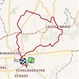
Randonnée Vélo électrique de 16,2 km à découvrir à Flandre, Flandre orientale, Renaix. Cette randonnée est proposée par bve9600.
Description
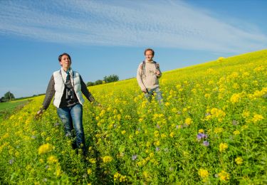
Super circuit avec chemins boisées et paysages de campagne.
Note: Aux étangs de Nukerke il n'est plus possible de faire le tour des étangs à vélo.
Localisation
Pays :
Belgique
Région :
Flandre
Département/Province :
Flandre orientale
Commune :
Renaix
Localité :
Ronse
Départ:(Dec)
Départ:(UTM)
543011 ; 5621420 (31U) N.
Commentaires
Randonnées à proximité
![Randonnée Marche Ellezelles - RB-Ha-02 - Ellezelles - 2024-10-29 - Photo](https://media.geolcdn.com/t/375/260/ext.jpg?maxdim=2&url=https%3A%2F%2Fservices.sitytrail.com%2FGeolivesWS%2FDownloadMedia.ashx%3FTrailID%3D217832%26Media%3D2f63cbc9-67e0-4d65-89f9-544523dd5718.jpg)
![Marche Marche](https://static1.geolcdn.com/sitytour/trail-icons/101.png)
RB-Ha-02 - Ellezelles - 2024-10-29
Marche
Très difficile
(4)
Ellezelles,
Wallonie,
Hainaut,
Belgique
![](/images/other/stat-length.png)
17,9 km | 22 km-effort
4h 56min
![](https://static1.geolcdn.com/siteimages/upload/files/16400158638029165_repeat_loop_refresh_sync_direction_icon.png)
Oui
![Randonnée Vélo électrique Renaix - Ellezelles par petits chemins pittoresques - Photo](https://media.geolcdn.com/t/375/260/e0aa3d15-f60d-4f83-a5a3-a0f3e8c9900b.jpg&format=jpg&maxdim=2)
![Vélo électrique Vélo électrique](https://static1.geolcdn.com/sitytour/trail-icons/205.png)
Ellezelles par petits chemins pittoresques
Vélo électrique
Facile
(1)
Renaix,
Flandre,
Flandre orientale,
Belgique
![](/images/other/stat-length.png)
15,9 km | 18,7 km-effort
1h 22min
![](https://static1.geolcdn.com/siteimages/upload/files/16400158638029165_repeat_loop_refresh_sync_direction_icon.png)
Oui
![Randonnée V.T.T. Renaix - Vers Musiekbos - Photo](https://media.geolcdn.com/t/375/260/ext.jpg?maxdim=2&url=https%3A%2F%2Fservices.sitytrail.com%2FGeolivesWS%2FDownloadMedia.ashx%3FTrailID%3D412567%26Media%3Dfix__20150426141940.jpg)
![V.T.T. V.T.T.](https://static1.geolcdn.com/sitytour/trail-icons/202.png)
Vers Musiekbos
V.T.T.
Moyen
(1)
Renaix,
Flandre,
Flandre orientale,
Belgique
![](/images/other/stat-length.png)
15,7 km | 18,6 km-effort
2h 1min
![](https://static1.geolcdn.com/siteimages/upload/files/16400158638029165_repeat_loop_refresh_sync_direction_icon.png)
Non
![Randonnée A pied Markedal - Muziekboswandeling - Photo](https://media.geolcdn.com/t/375/260/fc075cd6-bf31-4841-9a67-11027de5cfbf.jpeg&format=jpg&maxdim=2)
![A pied A pied](https://static1.geolcdn.com/sitytour/trail-icons/100.png)
Muziekboswandeling
A pied
Facile
(1)
Markedal,
Flandre,
Flandre orientale,
Belgique
![](/images/other/stat-length.png)
10,2 km | 13,3 km-effort
3h 1min
![](https://static1.geolcdn.com/siteimages/upload/files/16400158638029165_repeat_loop_refresh_sync_direction_icon.png)
Oui
![Randonnée Cheval Ellezelles - Boucle d'Ellezelles - Photo](https://media.geolcdn.com/t/375/260/ext.jpg?maxdim=2&url=https%3A%2F%2Fpivotmedia.tourismewallonie.be%2FANX-02-020D-00MD%2FANX-02-020D-00MD.jpg)
![Cheval Cheval](https://static1.geolcdn.com/sitytour/trail-icons/300.png)
Boucle d'Ellezelles
Cheval
Très facile
Ellezelles,
Wallonie,
Hainaut,
Belgique
![](/images/other/stat-length.png)
26 km | 30 km-effort
Inconnu
![](https://static1.geolcdn.com/siteimages/upload/files/16400158638029165_repeat_loop_refresh_sync_direction_icon.png)
Oui
![Randonnée A pied Frasnes-lez-Anvaing - Les](https://media.geolcdn.com/t/375/260/ext.jpg?maxdim=2&url=https%3A%2F%2Fpivotmedia.tourismewallonie.be%2FANX-02-03XZ-0092%2FANX-02-03XZ-0092.jpg)
![A pied A pied](https://static1.geolcdn.com/sitytour/trail-icons/100.png)
Les "Beaux Sites" Saint-Sauveur
A pied
Facile
Frasnes-lez-Anvaing,
Wallonie,
Hainaut,
Belgique
![](/images/other/stat-length.png)
10,9 km | 13,1 km-effort
2h 58min
![](https://static1.geolcdn.com/siteimages/upload/files/16400158638029165_repeat_loop_refresh_sync_direction_icon.png)
Oui
![Randonnée Marche Ellezelles - Ellezelles par champs et Ravel - Photo](https://media.geolcdn.com/t/375/260/ext.jpg?maxdim=2&url=https%3A%2F%2Fstatic1.geolcdn.com%2Fsiteimages%2Fupload%2Ffiles%2F1553511878bg_sport_marche.png)
![Marche Marche](https://static1.geolcdn.com/sitytour/trail-icons/101.png)
Ellezelles par champs et Ravel
Marche
Très facile
(1)
Ellezelles,
Wallonie,
Hainaut,
Belgique
![](/images/other/stat-length.png)
8,5 km | 9,9 km-effort
1h 47min
![](https://static1.geolcdn.com/siteimages/upload/files/16400158638029165_repeat_loop_refresh_sync_direction_icon.png)
Oui
![Randonnée Marche Ellezelles - Elezelles gare 18,7 km - Photo](https://media.geolcdn.com/t/375/260/5ec2193d-587d-4559-9e95-93a42101e080.jpg&format=jpg&maxdim=2)
![Marche Marche](https://static1.geolcdn.com/sitytour/trail-icons/101.png)
Elezelles gare 18,7 km
Marche
Moyen
(1)
Ellezelles,
Wallonie,
Hainaut,
Belgique
![](/images/other/stat-length.png)
19,2 km | 23 km-effort
4h 54min
![](https://static1.geolcdn.com/siteimages/upload/files/16400158638029165_repeat_loop_refresh_sync_direction_icon.png)
Oui
![Randonnée Marche Ellezelles - Marche Adeps à Ellezelles - Photo](https://media.geolcdn.com/t/375/260/4351fb9b-7acc-4b80-addb-172021992f2c.jpeg&format=jpg&maxdim=2)
![Marche Marche](https://static1.geolcdn.com/sitytour/trail-icons/101.png)
Marche Adeps à Ellezelles
Marche
Très facile
Ellezelles,
Wallonie,
Hainaut,
Belgique
![](/images/other/stat-length.png)
10,8 km | 13,3 km-effort
4h 22min
![](https://static1.geolcdn.com/siteimages/upload/files/16400158638029165_repeat_loop_refresh_sync_direction_icon.png)
Oui