![](/images/other/stat-length.png)
![Randonnée Marche Saint-Paul-Trois-Châteaux - St Restitut caves cathedrales - chapelle st Juste - Photo](https://media.geolcdn.com/t/1900/400/ext.pjpeg?maxdim=2&url=https%3A%2F%2Fstatic1.geolcdn.com%2Fsiteimages%2Fupload%2Ffiles%2F1553511878bg_sport_marche.png)
St Restitut caves cathedrales - chapelle st Juste
aitkhedache
Utilisateur
![Longueur](/images/other/stat-length.png)
Longueur
5,4 km
![Altitude max](https://static1.geolcdn.com/siteimages/upload/files/1508320355ic_sort_altitude_max_24dp.png)
Altitude max
280 m
![Dénivelé positif](https://static1.geolcdn.com/siteimages/upload/files/1508320355ic_sort_den_pos_24dp.png)
Dénivelé positif
117 m
![Km-Effort](/images/other/stat-length.png)
Km-Effort
7 km
![Altitude min](https://static1.geolcdn.com/siteimages/upload/files/1508320355ic_sort_altitude_min_24dp.png)
Altitude min
201 m
![Dénivelé négatif](https://static1.geolcdn.com/siteimages/upload/files/1508320355ic_sort_den_neg_24dp.png)
Dénivelé négatif
117 m
![Boucle](https://static1.geolcdn.com/siteimages/upload/files/16400158638029165_repeat_loop_refresh_sync_direction_icon.png)
Boucle
Oui
Date de création :
2019-02-20 18:28:05.156
Dernière modification :
2019-02-20 18:31:42.303
![Marche](https://static1.geolcdn.com/sitytour/trail-icons/101.png)
1h30
Difficulté : Moyen
![Scannez ce code QR pour ouvrir la randonnée dans l'application SityTrail](https://capi.geolives.com/qq0zvz2zws4bq2lad0pu/sitytour/trails/2037552/qr.png?size=200)
Application GPS de randonnée GRATUITE
À propos
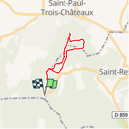
Randonnée Marche de 5,4 km à découvrir à Auvergne-Rhône-Alpes, Drôme, Saint-Paul-Trois-Châteaux. Cette randonnée est proposée par aitkhedache.
Description
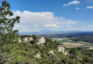
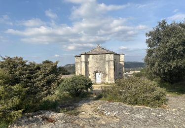
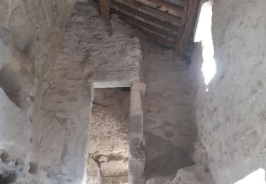
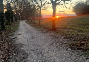
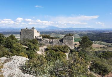
Depuis le parking des caves cathédrales, jusqu'à la chapelle St Juste en passant par les anciennes carrières.
Une promenade facile en sous-bois. La visite des anciennes carrières offre un terrain de jeux apprècié des enfants.
Localisation
Pays :
France
Région :
Auvergne-Rhône-Alpes
Département/Province :
Drôme
Commune :
Saint-Paul-Trois-Châteaux
Localité :
Unknown
Départ:(Dec)
Départ:(UTM)
640587 ; 4909605 (31T) N.
Commentaires
Randonnées à proximité
![Randonnée Marche Saint-Restitut - St Restitut Le Barry 12km - Photo](https://media.geolcdn.com/t/375/260/52d96bcf-650b-4fd0-a59a-69f2b2d3703d.jpg&format=jpg&maxdim=2)
![Marche Marche](https://static1.geolcdn.com/sitytour/trail-icons/101.png)
St Restitut Le Barry 12km
Marche
Moyen
(1)
Saint-Restitut,
Auvergne-Rhône-Alpes,
Drôme,
France
![](/images/other/stat-length.png)
12,2 km | 15,9 km-effort
3h 37min
![](https://static1.geolcdn.com/siteimages/upload/files/16400158638029165_repeat_loop_refresh_sync_direction_icon.png)
Oui
![Randonnée Marche Bollène - Barry Chabrières Enclume 7,5km - Photo](https://media.geolcdn.com/t/375/260/3a4e67d1-088f-449d-b525-af6a45f2f0d7.jpg&format=jpg&maxdim=2)
![Marche Marche](https://static1.geolcdn.com/sitytour/trail-icons/101.png)
Barry Chabrières Enclume 7,5km
Marche
Moyen
(1)
Bollène,
Provence-Alpes-Côte d'Azur,
Vaucluse,
France
![](/images/other/stat-length.png)
7,6 km | 10,1 km-effort
2h 30min
![](https://static1.geolcdn.com/siteimages/upload/files/16400158638029165_repeat_loop_refresh_sync_direction_icon.png)
Oui
![Randonnée Marche Saint-Restitut - St Restitut Barry 14km - Photo](https://media.geolcdn.com/t/375/260/919620e4-c2f5-475b-864c-8c28884f4028.jpg&format=jpg&maxdim=2)
![Marche Marche](https://static1.geolcdn.com/sitytour/trail-icons/101.png)
St Restitut Barry 14km
Marche
Moyen
(1)
Saint-Restitut,
Auvergne-Rhône-Alpes,
Drôme,
France
![](/images/other/stat-length.png)
13,7 km | 18,1 km-effort
5h 0min
![](https://static1.geolcdn.com/siteimages/upload/files/16400158638029165_repeat_loop_refresh_sync_direction_icon.png)
Oui
![Randonnée Marche Saint-Restitut - Les carrières de Sainte Juste - Saint Restitut - Photo](https://media.geolcdn.com/t/375/260/ext.jpg?maxdim=2&url=https%3A%2F%2Fservices.sitytrail.com%2FGeolivesWS%2FDownloadMedia.ashx%3FTrailID%3D317462%26Media%3D16693_6.jpg)
![Marche Marche](https://static1.geolcdn.com/sitytour/trail-icons/101.png)
Les carrières de Sainte Juste - Saint Restitut
Marche
Moyen
(2)
Saint-Restitut,
Auvergne-Rhône-Alpes,
Drôme,
France
![](/images/other/stat-length.png)
12,8 km | 16,8 km-effort
3h 30min
![](https://static1.geolcdn.com/siteimages/upload/files/16400158638029165_repeat_loop_refresh_sync_direction_icon.png)
Oui
![Randonnée V.T.T. Saint-Paul-Trois-Châteaux - VTT_13R_Le Val des Nymphes - Photo](https://media.geolcdn.com/t/375/260/ext.jpg?maxdim=2&url=https%3A%2F%2Fstatic1.geolcdn.com%2Fsiteimages%2Fupload%2Ffiles%2F1524743154velo.jpg)
![V.T.T. V.T.T.](https://static1.geolcdn.com/sitytour/trail-icons/202.png)
VTT_13R_Le Val des Nymphes
V.T.T.
Difficile
(1)
Saint-Paul-Trois-Châteaux,
Auvergne-Rhône-Alpes,
Drôme,
France
![](/images/other/stat-length.png)
33 km | 39 km-effort
2h 42min
![](https://static1.geolcdn.com/siteimages/upload/files/16400158638029165_repeat_loop_refresh_sync_direction_icon.png)
Oui
![Randonnée sport Saint-Restitut - St Restitut, Chabrieres, le Barry - Photo](https://media.geolcdn.com/t/375/260/63f81cb4-71f2-48a1-8bc8-eca4d8bcd53b.jpg&format=jpg&maxdim=2)
St Restitut, Chabrieres, le Barry
sport
Très facile
Saint-Restitut,
Auvergne-Rhône-Alpes,
Drôme,
France
![](/images/other/stat-length.png)
15,2 km | 21 km-effort
Inconnu
![](https://static1.geolcdn.com/siteimages/upload/files/16400158638029165_repeat_loop_refresh_sync_direction_icon.png)
Oui
![Randonnée Marche Saint-Restitut - st restitut moi - Photo](https://media.geolcdn.com/t/375/260/4cf52033-0bdc-4c01-93e4-f4a4eaa3e824.jpg&format=jpg&maxdim=2)
![Marche Marche](https://static1.geolcdn.com/sitytour/trail-icons/101.png)
st restitut moi
Marche
Moyen
Saint-Restitut,
Auvergne-Rhône-Alpes,
Drôme,
France
![](/images/other/stat-length.png)
17,4 km | 24 km-effort
5h 57min
![](https://static1.geolcdn.com/siteimages/upload/files/16400158638029165_repeat_loop_refresh_sync_direction_icon.png)
Oui
![Randonnée Marche Bollène - Chabrieres - Photo](https://media.geolcdn.com/t/375/260/a2cf1d96-3304-42ec-a5f3-48d51c2a9933.jpg&format=jpg&maxdim=2)
![Marche Marche](https://static1.geolcdn.com/sitytour/trail-icons/101.png)
Chabrieres
Marche
Moyen
Bollène,
Provence-Alpes-Côte d'Azur,
Vaucluse,
France
![](/images/other/stat-length.png)
5,2 km | 8,2 km-effort
2h 0min
![](https://static1.geolcdn.com/siteimages/upload/files/16400158638029165_repeat_loop_refresh_sync_direction_icon.png)
Oui
![Randonnée Marche Bollène - Barry Chabrières Enclume 7,5km - Photo](https://media.geolcdn.com/t/375/260/561ab73b-cfce-4ded-afd9-4c7b3caca3ea.jpg&format=jpg&maxdim=2)
![Marche Marche](https://static1.geolcdn.com/sitytour/trail-icons/101.png)
Barry Chabrières Enclume 7,5km
Marche
Moyen
Bollène,
Provence-Alpes-Côte d'Azur,
Vaucluse,
France
![](/images/other/stat-length.png)
7,4 km | 9,8 km-effort
2h 30min
![](https://static1.geolcdn.com/siteimages/upload/files/16400158638029165_repeat_loop_refresh_sync_direction_icon.png)
Oui