![](/images/other/stat-length.png)
![Randonnée Marche Entremont-le-Vieux - IBP64-Désert d'Entremont pointe de la Cochette - Photo](https://media.geolcdn.com/t/1900/400/bf506165-d755-40f3-9f5d-a14abc5c83b6.jpg&format=pjpeg&maxdim=2)
IBP64-Désert d'Entremont pointe de la Cochette
Bogapuki
Utilisateur
![Longueur](/images/other/stat-length.png)
Longueur
8,7 km
![Altitude max](https://static1.geolcdn.com/siteimages/upload/files/1508320355ic_sort_altitude_max_24dp.png)
Altitude max
1605 m
![Dénivelé positif](https://static1.geolcdn.com/siteimages/upload/files/1508320355ic_sort_den_pos_24dp.png)
Dénivelé positif
490 m
![Km-Effort](/images/other/stat-length.png)
Km-Effort
15,2 km
![Altitude min](https://static1.geolcdn.com/siteimages/upload/files/1508320355ic_sort_altitude_min_24dp.png)
Altitude min
1171 m
![Dénivelé négatif](https://static1.geolcdn.com/siteimages/upload/files/1508320355ic_sort_den_neg_24dp.png)
Dénivelé négatif
495 m
![Boucle](https://static1.geolcdn.com/siteimages/upload/files/16400158638029165_repeat_loop_refresh_sync_direction_icon.png)
Boucle
Oui
Date de création :
2019-02-18 09:14:04.984
Dernière modification :
2019-02-18 18:05:18.611
![Marche](https://static1.geolcdn.com/sitytour/trail-icons/101.png)
5h15
Difficulté : Moyen
![Scannez ce code QR pour ouvrir la randonnée dans l'application SityTrail](https://capi.geolives.com/qq0zvz2zws4bq2lad0pu/sitytour/trails/2036564/qr.png?size=200)
Application GPS de randonnée GRATUITE
À propos
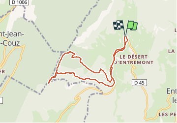
Randonnée Marche de 8,7 km à découvrir à Auvergne-Rhône-Alpes, Savoie, Entremont-le-Vieux. Cette randonnée est proposée par Bogapuki.
Description
18 février 2019
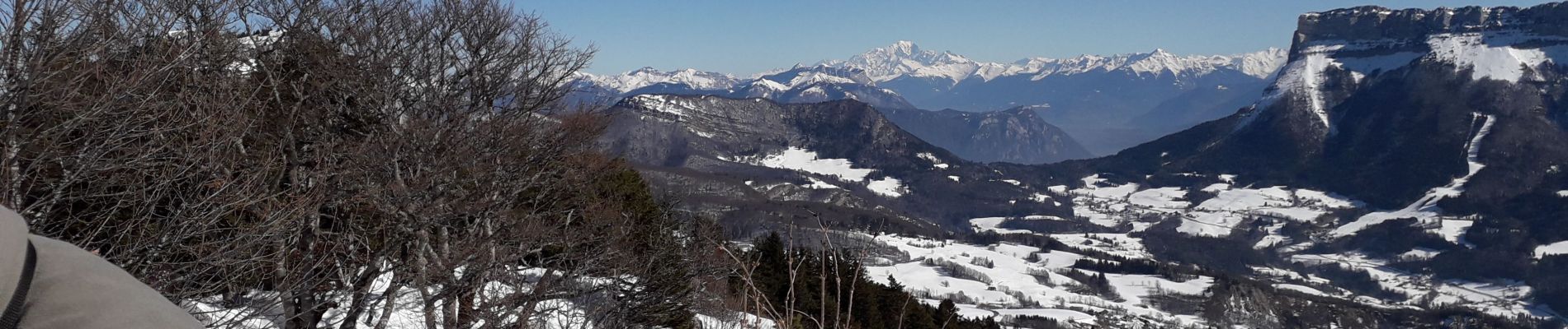
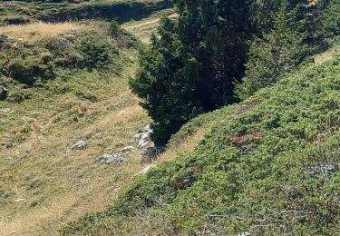
Boucle en raquette sous un beau soleil.
A réserver pour les randos d'été car majoritairement dans la forêt.
Localisation
Pays :
France
Région :
Auvergne-Rhône-Alpes
Département/Province :
Savoie
Commune :
Entremont-le-Vieux
Localité :
Unknown
Départ:(Dec)
Départ:(UTM)
723772 ; 5038779 (31T) N.
Commentaires
Randonnées à proximité
![Randonnée Marche Apremont - Mont Joigny, pte de la Georgat, la Lentille, le GD Carroz - Photo](https://media.geolcdn.com/t/375/260/34a799f3-15e1-4e29-b39c-0c906d59ce42.jpg&format=jpg&maxdim=2)
![Marche Marche](https://static1.geolcdn.com/sitytour/trail-icons/101.png)
Mont Joigny, pte de la Georgat, la Lentille, le GD Carroz
Marche
Facile
(1)
Apremont,
Auvergne-Rhône-Alpes,
Savoie,
France
![](/images/other/stat-length.png)
12,7 km | 23 km-effort
4h 3min
![](https://static1.geolcdn.com/siteimages/upload/files/16400158638029165_repeat_loop_refresh_sync_direction_icon.png)
Oui
![Randonnée Marche Entremont-le-Vieux - Le Mont Granier par la cheminée de Tencovaz - Photo](https://media.geolcdn.com/t/375/260/ext.jpg?maxdim=2&url=https%3A%2F%2Fservices.sitytrail.com%2FGeolivesWS%2FDownloadMedia.ashx%3FTrailID%3D103708%26Media%3D6232_1.jpg)
![Marche Marche](https://static1.geolcdn.com/sitytour/trail-icons/101.png)
Le Mont Granier par la cheminée de Tencovaz
Marche
Difficile
(3)
Entremont-le-Vieux,
Auvergne-Rhône-Alpes,
Savoie,
France
![](/images/other/stat-length.png)
9,6 km | 24 km-effort
5h 0min
![](https://static1.geolcdn.com/siteimages/upload/files/16400158638029165_repeat_loop_refresh_sync_direction_icon.png)
Oui
![Randonnée Marche Entremont-le-Vieux - Traversée du Mont Outheran 1676m - Photo](https://media.geolcdn.com/t/375/260/ext.jpg?maxdim=2&url=https%3A%2F%2Fservices.sitytrail.com%2FGeolivesWS%2FDownloadMedia.ashx%3FTrailID%3D101647%26Media%3D1855_1.jpg)
![Marche Marche](https://static1.geolcdn.com/sitytour/trail-icons/101.png)
Traversée du Mont Outheran 1676m
Marche
Difficile
(1)
Entremont-le-Vieux,
Auvergne-Rhône-Alpes,
Savoie,
France
![](/images/other/stat-length.png)
9 km | 15,9 km-effort
3h 30min
![](https://static1.geolcdn.com/siteimages/upload/files/16400158638029165_repeat_loop_refresh_sync_direction_icon.png)
Oui
![Randonnée Vélo de route Corbel - Entreront - Photo](https://media.geolcdn.com/t/375/260/9b42e589-105e-4d70-99b0-df835d2b48ea.jpg&format=jpg&maxdim=2)
![Vélo de route Vélo de route](https://static1.geolcdn.com/sitytour/trail-icons/201.png)
Entreront
Vélo de route
Très difficile
(1)
Corbel,
Auvergne-Rhône-Alpes,
Savoie,
France
![](/images/other/stat-length.png)
34 km | 49 km-effort
2h 53min
![](https://static1.geolcdn.com/siteimages/upload/files/16400158638029165_repeat_loop_refresh_sync_direction_icon.png)
Oui
![Randonnée Marche Entremont-le-Vieux - Le Granier par Tencovaz - Photo](https://media.geolcdn.com/t/375/260/0a6d7d9d-3ccb-410e-b45a-8510ed0c4da6.jpg&format=jpg&maxdim=2)
![Marche Marche](https://static1.geolcdn.com/sitytour/trail-icons/101.png)
Le Granier par Tencovaz
Marche
Difficile
Entremont-le-Vieux,
Auvergne-Rhône-Alpes,
Savoie,
France
![](/images/other/stat-length.png)
10,9 km | 27 km-effort
4h 46min
![](https://static1.geolcdn.com/siteimages/upload/files/16400158638029165_repeat_loop_refresh_sync_direction_icon.png)
Oui
![Randonnée Marche Entremont-le-Vieux - 38 outheran chartreuse - Photo](https://media.geolcdn.com/t/375/260/0718cfa5-92e3-4faf-aaef-e8783760fb24.jpg&format=jpg&maxdim=2)
![Marche Marche](https://static1.geolcdn.com/sitytour/trail-icons/101.png)
38 outheran chartreuse
Marche
Moyen
Entremont-le-Vieux,
Auvergne-Rhône-Alpes,
Savoie,
France
![](/images/other/stat-length.png)
16,5 km | 29 km-effort
6h 57min
![](https://static1.geolcdn.com/siteimages/upload/files/16400158638029165_repeat_loop_refresh_sync_direction_icon.png)
Oui
![Randonnée Raquettes à neige Entremont-le-Vieux - Chartreuse-Des Déserts au col du Mollard - Photo](https://media.geolcdn.com/t/375/260/ext.jpg?maxdim=2&url=https%3A%2F%2Fstatic1.geolcdn.com%2Fsiteimages%2Fupload%2Ffiles%2F1524743153raquette.jpg)
![Raquettes à neige Raquettes à neige](https://static1.geolcdn.com/sitytour/trail-icons/504.png)
Chartreuse-Des Déserts au col du Mollard
Raquettes à neige
Facile
(1)
Entremont-le-Vieux,
Auvergne-Rhône-Alpes,
Savoie,
France
![](/images/other/stat-length.png)
6,7 km | 9,8 km-effort
2h 26min
![](https://static1.geolcdn.com/siteimages/upload/files/16400158638029165_repeat_loop_refresh_sync_direction_icon.png)
Oui
![Randonnée Marche Entremont-le-Vieux - la Plagne le Pinet :en boucle partielle à partir de la bifurcation GR9 et montée au Pinet - Photo](https://media.geolcdn.com/t/375/260/56a80225-7b96-41d6-aae1-bac3ef64e473.jpg&format=jpg&maxdim=2)
![Marche Marche](https://static1.geolcdn.com/sitytour/trail-icons/101.png)
la Plagne le Pinet :en boucle partielle à partir de la bifurcation GR9 et mo...
Marche
Moyen
Entremont-le-Vieux,
Auvergne-Rhône-Alpes,
Savoie,
France
![](/images/other/stat-length.png)
12,9 km | 24 km-effort
3h 39min
![](https://static1.geolcdn.com/siteimages/upload/files/16400158638029165_repeat_loop_refresh_sync_direction_icon.png)
Oui
![Randonnée Marche Entremont-le-Vieux - 29 juillet 2023 mont Pinet et rocher de la Fita - Photo](https://media.geolcdn.com/t/375/260/1523d29f-6a1c-4efb-8cab-c63ad2e1b34c.jpg&format=jpg&maxdim=2)
![Marche Marche](https://static1.geolcdn.com/sitytour/trail-icons/101.png)
29 juillet 2023 mont Pinet et rocher de la Fita
Marche
Très difficile
Entremont-le-Vieux,
Auvergne-Rhône-Alpes,
Savoie,
France
![](/images/other/stat-length.png)
15 km | 27 km-effort
6h 2min
![](https://static1.geolcdn.com/siteimages/upload/files/16400158638029165_repeat_loop_refresh_sync_direction_icon.png)
Oui