![](/images/other/stat-length.png)
![Randonnée Marche Pétange - Mijnwerkerpad / Sentier Des Mineurs - Photo](https://media.geolcdn.com/t/1900/400/ext.pjpeg?maxdim=2&url=https%3A%2F%2Fstatic1.geolcdn.com%2Fsiteimages%2Fupload%2Ffiles%2F1553511878bg_sport_marche.png)
Mijnwerkerpad / Sentier Des Mineurs
flip96
Utilisateur
![Longueur](/images/other/stat-length.png)
Longueur
29 km
![Altitude max](https://static1.geolcdn.com/siteimages/upload/files/1508320355ic_sort_altitude_max_24dp.png)
Altitude max
433 m
![Dénivelé positif](https://static1.geolcdn.com/siteimages/upload/files/1508320355ic_sort_den_pos_24dp.png)
Dénivelé positif
665 m
![Km-Effort](/images/other/stat-length.png)
Km-Effort
38 km
![Altitude min](https://static1.geolcdn.com/siteimages/upload/files/1508320355ic_sort_altitude_min_24dp.png)
Altitude min
289 m
![Dénivelé négatif](https://static1.geolcdn.com/siteimages/upload/files/1508320355ic_sort_den_neg_24dp.png)
Dénivelé négatif
666 m
![Boucle](https://static1.geolcdn.com/siteimages/upload/files/16400158638029165_repeat_loop_refresh_sync_direction_icon.png)
Boucle
Oui
Date de création :
2014-12-10 00:00:00.0
Dernière modification :
2014-12-10 00:00:00.0
![Marche](https://static1.geolcdn.com/sitytour/trail-icons/101.png)
8h01
Difficulté : Moyen
![Scannez ce code QR pour ouvrir la randonnée dans l'application SityTrail](https://capi.geolives.com/qq0zvz2zws4bq2lad0pu/sitytour/trails/203432/qr.png?size=200)
Application GPS de randonnée GRATUITE
À propos
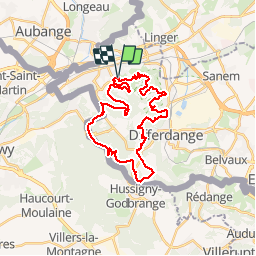
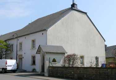
Randonnée Marche de 29 km à découvrir à Inconnu, Canton Esch-sur-Alzette, Pétange. Cette randonnée est proposée par flip96.
Description
Sentier des Mineurs vanuit Lamadelaine. Pad is aangegeven met gele bol. Markering is plaatselijk erg onduidelijk!!!
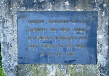
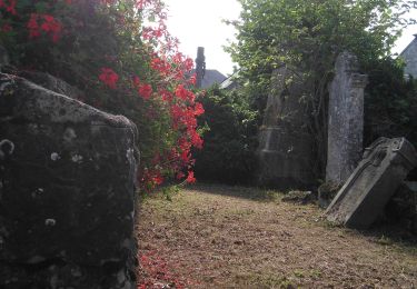
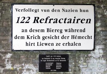
Mooie route, maar heb zelf ca. 35km. gelopen i.v.m. vele bezienswaardigheden onderweg.
Opmerkingen? flip96@home.nl
Localisation
Pays :
Luxembourg
Région :
Inconnu
Département/Province :
Canton Esch-sur-Alzette
Commune :
Pétange
Localité :
Unknown
Départ:(Dec)
Départ:(UTM)
706578 ; 5492137 (31U) N.
Commentaires
Randonnées à proximité
![Randonnée A pied Aubange - BE-AU 01 - Photo](https://media.geolcdn.com/t/375/260/7f7289b5-d5ab-4003-b78e-f5dd73f8883f.jpeg&format=jpg&maxdim=2)
![A pied A pied](https://static1.geolcdn.com/sitytour/trail-icons/100.png)
BE-AU 01
A pied
Facile
Aubange,
Wallonie,
Luxembourg,
Belgique
![](/images/other/stat-length.png)
12,2 km | 14,9 km-effort
3h 22min
![](https://static1.geolcdn.com/siteimages/upload/files/16400158638029165_repeat_loop_refresh_sync_direction_icon.png)
Oui
![Randonnée A pied Pétange - Auto-Pédestre Pétange - Photo](https://media.geolcdn.com/t/375/260/3bda8901-8a45-455f-a0d9-28619ac75e15.jpeg&format=jpg&maxdim=2)
![A pied A pied](https://static1.geolcdn.com/sitytour/trail-icons/100.png)
Auto-Pédestre Pétange
A pied
Facile
Pétange,
Inconnu,
Canton Esch-sur-Alzette,
Luxembourg
![](/images/other/stat-length.png)
8,3 km | 10,4 km-effort
2h 21min
![](https://static1.geolcdn.com/siteimages/upload/files/16400158638029165_repeat_loop_refresh_sync_direction_icon.png)
Oui
![Randonnée A pied Pétange - Auto-Pédestre Lamadelaine - Photo](https://media.geolcdn.com/t/375/260/b8abde83-d7ee-4d08-8b56-7c6d44fc17fc.jpeg&format=jpg&maxdim=2)
![A pied A pied](https://static1.geolcdn.com/sitytour/trail-icons/100.png)
Auto-Pédestre Lamadelaine
A pied
Facile
Pétange,
Inconnu,
Canton Esch-sur-Alzette,
Luxembourg
![](/images/other/stat-length.png)
10,8 km | 13,4 km-effort
3h 2min
![](https://static1.geolcdn.com/siteimages/upload/files/16400158638029165_repeat_loop_refresh_sync_direction_icon.png)
Oui
![Randonnée A pied Charage - Sentier Naturfrenn Käerjéng - Photo](https://media.geolcdn.com/t/375/260/60dcdf91-6252-4ac8-b795-309bfee6f33c.jpeg&format=jpg&maxdim=2)
![A pied A pied](https://static1.geolcdn.com/sitytour/trail-icons/100.png)
Sentier Naturfrenn Käerjéng
A pied
Facile
Charage,
Inconnu,
Canton Capellen,
Luxembourg
![](/images/other/stat-length.png)
8,5 km | 10,4 km-effort
2h 22min
![](https://static1.geolcdn.com/siteimages/upload/files/16400158638029165_repeat_loop_refresh_sync_direction_icon.png)
Oui
![Randonnée A pied Charage - Auto-Pédestre Bascharage - Photo](https://media.geolcdn.com/t/375/260/f1279973-8e1f-4680-90f5-548cd507bf83.jpeg&format=jpg&maxdim=2)
![A pied A pied](https://static1.geolcdn.com/sitytour/trail-icons/100.png)
Auto-Pédestre Bascharage
A pied
Facile
Charage,
Inconnu,
Canton Capellen,
Luxembourg
![](/images/other/stat-length.png)
9 km | 10,6 km-effort
2h 24min
![](https://static1.geolcdn.com/siteimages/upload/files/16400158638029165_repeat_loop_refresh_sync_direction_icon.png)
Oui
![Randonnée A pied Aubange - Le Joli Bois - Photo](https://media.geolcdn.com/t/375/260/004d9deb-44d3-48df-b1f8-dbcc850899c2.jpeg&format=jpg&maxdim=2)
![A pied A pied](https://static1.geolcdn.com/sitytour/trail-icons/100.png)
Le Joli Bois
A pied
Facile
Aubange,
Wallonie,
Luxembourg,
Belgique
![](/images/other/stat-length.png)
8,5 km | 11,7 km-effort
2h 39min
![](https://static1.geolcdn.com/siteimages/upload/files/16400158638029165_repeat_loop_refresh_sync_direction_icon.png)
Oui
![Randonnée A pied Haucourt-Moulaine - Sentier du Beau Chêne - Photo](https://media.geolcdn.com/t/375/260/f060c4d5-b3a7-4872-84e5-b1f11835f082.jpeg&format=jpg&maxdim=2)
![A pied A pied](https://static1.geolcdn.com/sitytour/trail-icons/100.png)
Sentier du Beau Chêne
A pied
Facile
Haucourt-Moulaine,
Grand Est,
Meurthe-et-Moselle,
France
![](/images/other/stat-length.png)
10,8 km | 13,7 km-effort
3h 6min
![](https://static1.geolcdn.com/siteimages/upload/files/16400158638029165_repeat_loop_refresh_sync_direction_icon.png)
Oui
![Randonnée A pied Differdange - Sentier du Temps Perdu - Photo](https://media.geolcdn.com/t/375/260/f2ec4c4a-e3b0-42a8-a4b9-f770a42da903.jpeg&format=jpg&maxdim=2)
![A pied A pied](https://static1.geolcdn.com/sitytour/trail-icons/100.png)
Sentier du Temps Perdu
A pied
Facile
Differdange,
Inconnu,
Canton Esch-sur-Alzette,
Luxembourg
![](/images/other/stat-length.png)
6,6 km | 9,1 km-effort
2h 4min
![](https://static1.geolcdn.com/siteimages/upload/files/16400158638029165_repeat_loop_refresh_sync_direction_icon.png)
Oui
![Randonnée A pied Charage - Auto-Pédestre Clemency 2 - Photo](https://media.geolcdn.com/t/375/260/6e6d7a4f-b83f-4d40-a520-6650674faa3f.jpeg&format=jpg&maxdim=2)
![A pied A pied](https://static1.geolcdn.com/sitytour/trail-icons/100.png)
Auto-Pédestre Clemency 2
A pied
Facile
Charage,
Inconnu,
Canton Capellen,
Luxembourg
![](/images/other/stat-length.png)
8,4 km | 10 km-effort
2h 16min
![](https://static1.geolcdn.com/siteimages/upload/files/16400158638029165_repeat_loop_refresh_sync_direction_icon.png)
Oui