![](/images/other/stat-length.png)
![Randonnée Marche Boué - Le sentier de Bo-we - Photo](https://media.geolcdn.com/t/1900/400/ext.pjpeg?maxdim=2&url=https%3A%2F%2Fstatic1.geolcdn.com%2Fsiteimages%2Fupload%2Ffiles%2F1553511878bg_sport_marche.png)
Le sentier de Bo-we
Rando Famili
Randonnées de RandoFamili
![Longueur](/images/other/stat-length.png)
Longueur
971 m
![Altitude max](https://static1.geolcdn.com/siteimages/upload/files/1508320355ic_sort_altitude_max_24dp.png)
Altitude max
168 m
![Dénivelé positif](https://static1.geolcdn.com/siteimages/upload/files/1508320355ic_sort_den_pos_24dp.png)
Dénivelé positif
10 m
![Km-Effort](/images/other/stat-length.png)
Km-Effort
1,1 km
![Altitude min](https://static1.geolcdn.com/siteimages/upload/files/1508320355ic_sort_altitude_min_24dp.png)
Altitude min
148 m
![Dénivelé négatif](https://static1.geolcdn.com/siteimages/upload/files/1508320355ic_sort_den_neg_24dp.png)
Dénivelé négatif
17 m
![Boucle](https://static1.geolcdn.com/siteimages/upload/files/16400158638029165_repeat_loop_refresh_sync_direction_icon.png)
Boucle
Non
Date de création :
2014-12-10 00:00:00.0
Dernière modification :
2014-12-10 00:00:00.0
![Marche](https://static1.geolcdn.com/sitytour/trail-icons/101.png)
--
Difficulté : Inconnu
![Scannez ce code QR pour ouvrir la randonnée dans l'application SityTrail](https://capi.geolives.com/qq0zvz2zws4bq2lad0pu/sitytour/trails/202841/qr.png?size=200)
Application GPS de randonnée GRATUITE
À propos
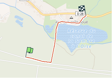
Randonnée Marche de 971 m à découvrir à Hauts-de-France, Aisne, Boué. Cette randonnée est proposée par Rando Famili.
Description
Cité industrielle en milieu rural, Boué vous propose un très joli circuit d'interprétation pour toute la famille où de nombreux panneaux vous décriront la faune et la flore locales.
Photos
Localisation
Pays :
France
Région :
Hauts-de-France
Département/Province :
Aisne
Commune :
Boué
Localité :
Unknown
Départ:(Dec)
Départ:(UTM)
550325 ; 5539577 (31U) N.
Commentaires
Randonnées à proximité
![Randonnée Marche Étreux - Le Canal - Photo](https://media.geolcdn.com/t/375/260/ext.jpg?maxdim=2&url=https%3A%2F%2Fservices.sitytrail.com%2FGeolivesWS%2FDownloadMedia.ashx%3FTrailID%3D108323%26Media%3D994_2.jpg)
![Marche Marche](https://static1.geolcdn.com/sitytour/trail-icons/101.png)
Le Canal
Marche
Moyen
(1)
Étreux,
Hauts-de-France,
Aisne,
France
![](/images/other/stat-length.png)
12,5 km | 13,8 km-effort
3h 15min
![](https://static1.geolcdn.com/siteimages/upload/files/16400158638029165_repeat_loop_refresh_sync_direction_icon.png)
Oui
![Randonnée Marche Étreux - Le Canal - variante - Photo](https://media.geolcdn.com/t/375/260/ext.jpg?maxdim=2&url=https%3A%2F%2Fstatic1.geolcdn.com%2Fsiteimages%2Fupload%2Ffiles%2F1553511878bg_sport_marche.png)
![Marche Marche](https://static1.geolcdn.com/sitytour/trail-icons/101.png)
Le Canal - variante
Marche
Moyen
Étreux,
Hauts-de-France,
Aisne,
France
![](/images/other/stat-length.png)
10,2 km | 11,2 km-effort
2h 30min
![](https://static1.geolcdn.com/siteimages/upload/files/16400158638029165_repeat_loop_refresh_sync_direction_icon.png)
Oui
![Randonnée Marche Fesmy-le-Sart - fesmy_le _sars - Photo](https://media.geolcdn.com/t/375/260/ext.jpg?maxdim=2&url=https%3A%2F%2Fstatic1.geolcdn.com%2Fsiteimages%2Fupload%2Ffiles%2F1553511878bg_sport_marche.png)
![Marche Marche](https://static1.geolcdn.com/sitytour/trail-icons/101.png)
fesmy_le _sars
Marche
Très facile
(1)
Fesmy-le-Sart,
Hauts-de-France,
Aisne,
France
![](/images/other/stat-length.png)
10,5 km | 11,5 km-effort
2h 27min
![](https://static1.geolcdn.com/siteimages/upload/files/16400158638029165_repeat_loop_refresh_sync_direction_icon.png)
Oui
![Randonnée Marche La Neuville-lès-Dorengt - boué ballade le long du cana - Photo](https://media.geolcdn.com/t/375/260/ext.jpg?maxdim=2&url=https%3A%2F%2Fstatic1.geolcdn.com%2Fsiteimages%2Fupload%2Ffiles%2F1553511878bg_sport_marche.png)
![Marche Marche](https://static1.geolcdn.com/sitytour/trail-icons/101.png)
boué ballade le long du cana
Marche
Très facile
La Neuville-lès-Dorengt,
Hauts-de-France,
Aisne,
France
![](/images/other/stat-length.png)
11,7 km | 12,9 km-effort
2h 41min
![](https://static1.geolcdn.com/siteimages/upload/files/16400158638029165_repeat_loop_refresh_sync_direction_icon.png)
Non
![Randonnée Course à pied Boué - boué - Photo](https://media.geolcdn.com/t/375/260/ext.jpg?maxdim=2&url=https%3A%2F%2Fstatic1.geolcdn.com%2Fsiteimages%2Fupload%2Ffiles%2F1524743154running.jpg)
![Course à pied Course à pied](https://static1.geolcdn.com/sitytour/trail-icons/103.png)
boué
Course à pied
Très facile
Boué,
Hauts-de-France,
Aisne,
France
![](/images/other/stat-length.png)
10,8 km | 12,4 km-effort
1h 14min
![](https://static1.geolcdn.com/siteimages/upload/files/16400158638029165_repeat_loop_refresh_sync_direction_icon.png)
Oui