![](/images/other/stat-length.png)
![Randonnée Marche Château-Thierry - La cote 204 - Photo](https://media.geolcdn.com/t/1900/400/ext.pjpeg?maxdim=2&url=https%3A%2F%2Fservices.sitytrail.com%2FGeolivesWS%2FDownloadMedia.ashx%3FTrailID%3D202821%26Media%3D4cec11ac-d533-445a-81de-e94f43b22319.jpg)
La cote 204
Rando Famili
Randonnées de RandoFamili
![Longueur](/images/other/stat-length.png)
![Altitude max](https://static1.geolcdn.com/siteimages/upload/files/1508320355ic_sort_altitude_max_24dp.png)
![Dénivelé positif](https://static1.geolcdn.com/siteimages/upload/files/1508320355ic_sort_den_pos_24dp.png)
![Km-Effort](/images/other/stat-length.png)
![Altitude min](https://static1.geolcdn.com/siteimages/upload/files/1508320355ic_sort_altitude_min_24dp.png)
![Dénivelé négatif](https://static1.geolcdn.com/siteimages/upload/files/1508320355ic_sort_den_neg_24dp.png)
![Boucle](https://static1.geolcdn.com/siteimages/upload/files/16400158638029165_repeat_loop_refresh_sync_direction_icon.png)
![Marche](https://static1.geolcdn.com/sitytour/trail-icons/101.png)
--
Difficulté : Inconnu
![Scannez ce code QR pour ouvrir la randonnée dans l'application SityTrail](https://capi.geolives.com/qq0zvz2zws4bq2lad0pu/sitytour/trails/202821/qr.png?size=200)
Application GPS de randonnée GRATUITE
À propos
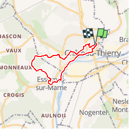
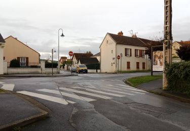
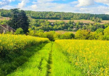
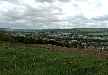
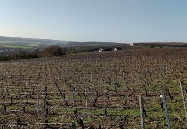
Randonnée Marche de 9,9 km à découvrir à Hauts-de-France, Aisne, Château-Thierry. Cette randonnée est proposée par Rando Famili.
Description
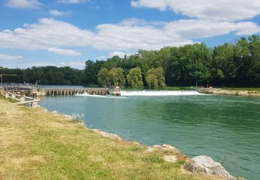
Un site stratégique qui fut constamment fortifié, Château-Thierry, un monument perpétuant le souvenir de l'engagement américain, le mémorial de la cote 204, et l'un des plus beaux monuments gothiques de la région, l'abbatiale d'Essômes, forment le décor de ce circuit qui se déroule le long de la Marne.
Points d'intérêt
Localisation
Commentaires
Randonnées à proximité
![Randonnée Marche Château-Thierry - Château-Thierry du 20-10-2024 - Photo](https://media.geolcdn.com/t/375/260/01f4364c-7132-4755-84cb-ad0105634b93.jpg&format=jpg&maxdim=2)
![Marche Marche](https://static1.geolcdn.com/sitytour/trail-icons/101.png)
Marche
![](/images/other/stat-length.png)
![](https://static1.geolcdn.com/siteimages/upload/files/16400158638029165_repeat_loop_refresh_sync_direction_icon.png)
![Randonnée Marche Château-Thierry - Le chemin de St Colomban en IDF Etape 1 Chateau Thierry - Nanteuil sur Marne - Photo](https://media.geolcdn.com/t/375/260/9609d3ad-ab5e-4f8f-9f67-aa273e117c14.jpg&format=jpg&maxdim=2)
![Marche Marche](https://static1.geolcdn.com/sitytour/trail-icons/101.png)
Marche
![](/images/other/stat-length.png)
![](https://static1.geolcdn.com/siteimages/upload/files/16400158638029165_repeat_loop_refresh_sync_direction_icon.png)
![Randonnée Marche Château-Thierry - Les Vignes Castelles trace du 28-04-2024 - Photo](https://media.geolcdn.com/t/375/260/4b525fce-e0c7-44a3-ac4d-c251652c2d56.jpg&format=jpg&maxdim=2)
![Marche Marche](https://static1.geolcdn.com/sitytour/trail-icons/101.png)
Marche
![](/images/other/stat-length.png)
![](https://static1.geolcdn.com/siteimages/upload/files/16400158638029165_repeat_loop_refresh_sync_direction_icon.png)
![Randonnée Marche Château-Thierry - Les vignes Castelles - version 8 km - Photo](https://media.geolcdn.com/t/375/260/02397956-c095-41df-bc0b-2c08db7076aa.jpg&format=jpg&maxdim=2)
![Marche Marche](https://static1.geolcdn.com/sitytour/trail-icons/101.png)
Marche
![](/images/other/stat-length.png)
![](https://static1.geolcdn.com/siteimages/upload/files/16400158638029165_repeat_loop_refresh_sync_direction_icon.png)
![Randonnée Marche Chierry - Chierry - Photo](https://media.geolcdn.com/t/375/260/ext.jpg?maxdim=2&url=https%3A%2F%2Fstatic1.geolcdn.com%2Fsiteimages%2Fupload%2Ffiles%2F1553511878bg_sport_marche.png)
![Marche Marche](https://static1.geolcdn.com/sitytour/trail-icons/101.png)
Marche
![](/images/other/stat-length.png)
![](https://static1.geolcdn.com/siteimages/upload/files/16400158638029165_repeat_loop_refresh_sync_direction_icon.png)
![Randonnée Marche Nesles-la-Montagne - Nesles la Montagne du 02/06/2020 - Photo](https://media.geolcdn.com/t/375/260/e9e49450-fac4-4ee3-aafc-a88d23d73e0c.jpg&format=jpg&maxdim=2)
![Marche Marche](https://static1.geolcdn.com/sitytour/trail-icons/101.png)
Marche
![](/images/other/stat-length.png)
![](https://static1.geolcdn.com/siteimages/upload/files/16400158638029165_repeat_loop_refresh_sync_direction_icon.png)
![Randonnée V.T.T. Château-Thierry - Château / Mont St Père / Azy / Château - Photo](https://media.geolcdn.com/t/375/260/faaee0cb-6e62-4da4-afa4-df40725828c1.jpg&format=jpg&maxdim=2)
![V.T.T. V.T.T.](https://static1.geolcdn.com/sitytour/trail-icons/202.png)
V.T.T.
![](/images/other/stat-length.png)
![](https://static1.geolcdn.com/siteimages/upload/files/16400158638029165_repeat_loop_refresh_sync_direction_icon.png)
![Randonnée Marche Château-Thierry - Château - Aulnois - Château du 26/05/2020 - Photo](https://media.geolcdn.com/t/375/260/5c13f2d8-e6c8-4489-a7e8-8e373eb07263.jpg&format=jpg&maxdim=2)
![Marche Marche](https://static1.geolcdn.com/sitytour/trail-icons/101.png)
Marche
![](/images/other/stat-length.png)
![](https://static1.geolcdn.com/siteimages/upload/files/16400158638029165_repeat_loop_refresh_sync_direction_icon.png)
![Randonnée Course à pied Verdilly - Verdilly Balcons de la Marne - Photo](https://media.geolcdn.com/t/375/260/ext.jpg?maxdim=2&url=https%3A%2F%2Fstatic1.geolcdn.com%2Fsiteimages%2Fupload%2Ffiles%2F1524743154running.jpg)
![Course à pied Course à pied](https://static1.geolcdn.com/sitytour/trail-icons/103.png)
Course à pied
![](/images/other/stat-length.png)
![](https://static1.geolcdn.com/siteimages/upload/files/16400158638029165_repeat_loop_refresh_sync_direction_icon.png)