![](/images/other/stat-length.png)
![Randonnée A pied Saint-Raphaël - Tour du pic du Cap Roux et Ste Baume ( grotte Chapelle ) - Photo](https://media.geolcdn.com/t/1900/400/3a46cbef-310a-4942-8f15-d6dbf7802cee.jpg&format=pjpeg&maxdim=2)
Tour du pic du Cap Roux et Ste Baume ( grotte Chapelle )
domi06
Utilisateur
![Longueur](/images/other/stat-length.png)
Longueur
11,7 km
![Altitude max](https://static1.geolcdn.com/siteimages/upload/files/1508320355ic_sort_altitude_max_24dp.png)
Altitude max
440 m
![Dénivelé positif](https://static1.geolcdn.com/siteimages/upload/files/1508320355ic_sort_den_pos_24dp.png)
Dénivelé positif
639 m
![Km-Effort](/images/other/stat-length.png)
Km-Effort
20 km
![Altitude min](https://static1.geolcdn.com/siteimages/upload/files/1508320355ic_sort_altitude_min_24dp.png)
Altitude min
28 m
![Dénivelé négatif](https://static1.geolcdn.com/siteimages/upload/files/1508320355ic_sort_den_neg_24dp.png)
Dénivelé négatif
638 m
![Boucle](https://static1.geolcdn.com/siteimages/upload/files/16400158638029165_repeat_loop_refresh_sync_direction_icon.png)
Boucle
Oui
Date de création :
2019-01-20 09:56:35.208
Dernière modification :
2019-02-22 10:04:30.236
![A pied](https://static1.geolcdn.com/sitytour/trail-icons/100.png)
59m
Difficulté : Moyen
![Scannez ce code QR pour ouvrir la randonnée dans l'application SityTrail](https://capi.geolives.com/qq0zvz2zws4bq2lad0pu/sitytour/trails/2024602/qr.png?size=200)
Application GPS de randonnée GRATUITE
À propos
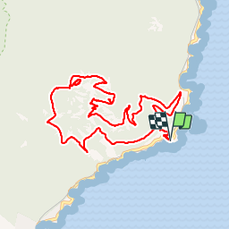
Randonnée A pied de 11,7 km à découvrir à Provence-Alpes-Côte d'Azur, Var, Saint-Raphaël. Cette randonnée est proposée par domi06.
Description
Départ de la pointe de l'observatoire. Rocher de St Barthelemy. Direction col du Pilon, AR grotte de la Chapelle. Pic du Cap Roux . Descente par Col du Cap Roux.
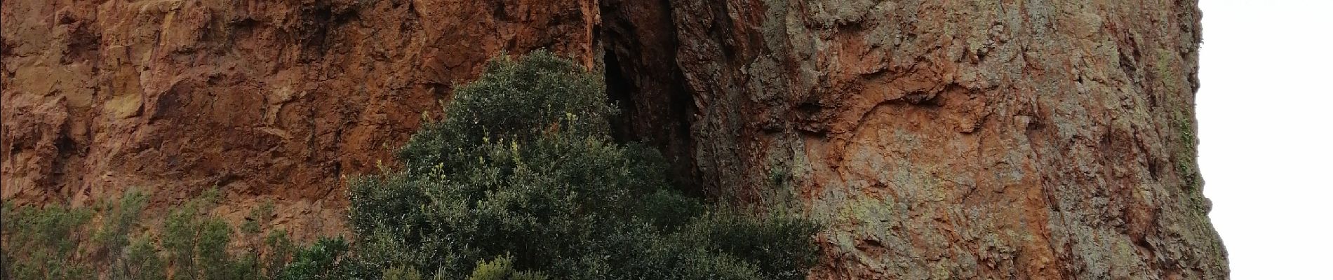
Magnifiques points de vue tout au long du parcours
Localisation
Pays :
France
Région :
Provence-Alpes-Côte d'Azur
Département/Province :
Var
Commune :
Saint-Raphaël
Localité :
Unknown
Départ:(Dec)
Départ:(UTM)
331508 ; 4812808 (32T) N.
Commentaires
Randonnées à proximité
![Randonnée Marche Saint-Raphaël - Massif d'ésterel-grande boucle pic cap roux - Photo](https://media.geolcdn.com/t/375/260/75f5531d-898d-4f51-8086-6652c6aad722.jpg&format=jpg&maxdim=2)
![Marche Marche](https://static1.geolcdn.com/sitytour/trail-icons/101.png)
Massif d'ésterel-grande boucle pic cap roux
Marche
Moyen
(2)
Saint-Raphaël,
Provence-Alpes-Côte d'Azur,
Var,
France
![](/images/other/stat-length.png)
10,4 km | 17,5 km-effort
2h 58min
![](https://static1.geolcdn.com/siteimages/upload/files/16400158638029165_repeat_loop_refresh_sync_direction_icon.png)
Oui
![Randonnée Marche Saint-Raphaël - Le tour du Pic du Cap Roux - St Raphaël (Agay) - Photo](https://media.geolcdn.com/t/375/260/ext.jpg?maxdim=2&url=https%3A%2F%2Fservices.sitytrail.com%2FGeolivesWS%2FDownloadMedia.ashx%3FTrailID%3D317929%26Media%3D17353_6.jpg)
![Marche Marche](https://static1.geolcdn.com/sitytour/trail-icons/101.png)
Le tour du Pic du Cap Roux - St Raphaël (Agay)
Marche
Moyen
(2)
Saint-Raphaël,
Provence-Alpes-Côte d'Azur,
Var,
France
![](/images/other/stat-length.png)
7,2 km | 12,8 km-effort
2h 0min
![](https://static1.geolcdn.com/siteimages/upload/files/16400158638029165_repeat_loop_refresh_sync_direction_icon.png)
Oui
![Randonnée Marche Saint-Raphaël - Pic du Cap Roux - Photo](https://media.geolcdn.com/t/375/260/ext.jpg?maxdim=2&url=https%3A%2F%2Fservices.sitytrail.com%2FGeolivesWS%2FDownloadMedia.ashx%3FTrailID%3D230669%26Media%3Dfix__20131103111411.jpg)
![Marche Marche](https://static1.geolcdn.com/sitytour/trail-icons/101.png)
Pic du Cap Roux
Marche
Très facile
(4)
Saint-Raphaël,
Provence-Alpes-Côte d'Azur,
Var,
France
![](/images/other/stat-length.png)
4,1 km | 7,8 km-effort
1h 17min
![](https://static1.geolcdn.com/siteimages/upload/files/16400158638029165_repeat_loop_refresh_sync_direction_icon.png)
Oui
![Randonnée Marche Saint-Raphaël - Théoule ND - Aiguille - Photo](https://media.geolcdn.com/t/375/260/ext.jpg?maxdim=2&url=https%3A%2F%2Fstatic1.geolcdn.com%2Fsiteimages%2Fupload%2Ffiles%2F1553511878bg_sport_marche.png)
![Marche Marche](https://static1.geolcdn.com/sitytour/trail-icons/101.png)
Théoule ND - Aiguille
Marche
Très difficile
(1)
Saint-Raphaël,
Provence-Alpes-Côte d'Azur,
Var,
France
![](/images/other/stat-length.png)
18,1 km | 29 km-effort
6h 40min
![](https://static1.geolcdn.com/siteimages/upload/files/16400158638029165_repeat_loop_refresh_sync_direction_icon.png)
Oui
![Randonnée Marche Saint-Raphaël - Agay - Sainte-Barbe - Étang des Nénuphares - Photo](https://media.geolcdn.com/t/375/260/dfb7073a-02d4-4811-84ba-99dc2878a0d2.jpg&format=jpg&maxdim=2)
![Marche Marche](https://static1.geolcdn.com/sitytour/trail-icons/101.png)
Agay - Sainte-Barbe - Étang des Nénuphares
Marche
Facile
(2)
Saint-Raphaël,
Provence-Alpes-Côte d'Azur,
Var,
France
![](/images/other/stat-length.png)
5 km | 6,2 km-effort
2h 8min
![](https://static1.geolcdn.com/siteimages/upload/files/16400158638029165_repeat_loop_refresh_sync_direction_icon.png)
Oui
![Randonnée Marche Saint-Raphaël - Tour du Pic de l'Ours - Le Trayas - Photo](https://media.geolcdn.com/t/375/260/ext.jpg?maxdim=2&url=https%3A%2F%2Fservices.sitytrail.com%2FGeolivesWS%2FDownloadMedia.ashx%3FTrailID%3D191486%26Media%3D15078_2.jpg)
![Marche Marche](https://static1.geolcdn.com/sitytour/trail-icons/101.png)
Tour du Pic de l'Ours - Le Trayas
Marche
Moyen
(1)
Saint-Raphaël,
Provence-Alpes-Côte d'Azur,
Var,
France
![](/images/other/stat-length.png)
9,5 km | 16 km-effort
3h 0min
![](https://static1.geolcdn.com/siteimages/upload/files/16400158638029165_repeat_loop_refresh_sync_direction_icon.png)
Oui
![Randonnée Marche Saint-Raphaël - Rando des Etangs - Photo](https://media.geolcdn.com/t/375/260/33bb8feb-dce4-4c92-bacc-ea49f2230fc9.jpg&format=jpg&maxdim=2)
![Marche Marche](https://static1.geolcdn.com/sitytour/trail-icons/101.png)
Rando des Etangs
Marche
Très difficile
Saint-Raphaël,
Provence-Alpes-Côte d'Azur,
Var,
France
![](/images/other/stat-length.png)
16,1 km | 22 km-effort
4h 1min
![](https://static1.geolcdn.com/siteimages/upload/files/16400158638029165_repeat_loop_refresh_sync_direction_icon.png)
Oui
![Randonnée Marche Saint-Raphaël - Dent et Pic de l'Ours - Pic d'Aurelle depuis le Col Belle Barbe - Photo](https://media.geolcdn.com/t/375/260/4303c42f-248d-490a-8d87-48bd2cb53ff8.jpg&format=jpg&maxdim=2)
![Marche Marche](https://static1.geolcdn.com/sitytour/trail-icons/101.png)
Dent et Pic de l'Ours - Pic d'Aurelle depuis le Col Belle Barbe
Marche
Difficile
Saint-Raphaël,
Provence-Alpes-Côte d'Azur,
Var,
France
![](/images/other/stat-length.png)
17,5 km | 25 km-effort
4h 50min
![](https://static1.geolcdn.com/siteimages/upload/files/16400158638029165_repeat_loop_refresh_sync_direction_icon.png)
Oui
![Randonnée Marche Saint-Raphaël - Le tour du Perthus Oriental 2 - Photo](https://media.geolcdn.com/t/375/260/58751db2-2f84-478b-945a-f0594731e6ca.jpg&format=jpg&maxdim=2)
![Marche Marche](https://static1.geolcdn.com/sitytour/trail-icons/101.png)
Le tour du Perthus Oriental 2
Marche
Difficile
Saint-Raphaël,
Provence-Alpes-Côte d'Azur,
Var,
France
![](/images/other/stat-length.png)
11,2 km | 14,8 km-effort
3h 21min
![](https://static1.geolcdn.com/siteimages/upload/files/16400158638029165_repeat_loop_refresh_sync_direction_icon.png)
Oui