![](/images/other/stat-length.png)
![Randonnée Autre activité Quarten - Spitzmeilen ab Flumserberg - Photo](https://media.geolcdn.com/t/1900/400/ext.pjpeg?maxdim=2&url=https%3A%2F%2Fstatic1.geolcdn.com%2Fsiteimages%2Fupload%2Ffiles%2F1545311037marcheuse_200dpi.jpg)
Spitzmeilen ab Flumserberg
jschna
Utilisateur
![Longueur](/images/other/stat-length.png)
![Altitude max](https://static1.geolcdn.com/siteimages/upload/files/1508320355ic_sort_altitude_max_24dp.png)
![Dénivelé positif](https://static1.geolcdn.com/siteimages/upload/files/1508320355ic_sort_den_pos_24dp.png)
![Km-Effort](/images/other/stat-length.png)
![Altitude min](https://static1.geolcdn.com/siteimages/upload/files/1508320355ic_sort_altitude_min_24dp.png)
![Dénivelé négatif](https://static1.geolcdn.com/siteimages/upload/files/1508320355ic_sort_den_neg_24dp.png)
![Boucle](https://static1.geolcdn.com/siteimages/upload/files/16400158638029165_repeat_loop_refresh_sync_direction_icon.png)
![Autre activité](https://static1.geolcdn.com/sitytour/trail-icons/900.png)
--
Difficulté : Inconnu
![Scannez ce code QR pour ouvrir la randonnée dans l'application SityTrail](https://capi.geolives.com/qq0zvz2zws4bq2lad0pu/sitytour/trails/20239/qr.png?size=200)
Application GPS de randonnée GRATUITE
À propos
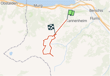
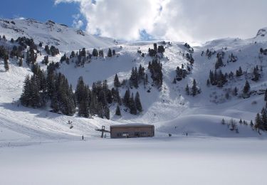
Randonnée Autre activité de 15,6 km à découvrir à Saint-Gall, Wahlkreis Sarganserland, Quarten. Cette randonnée est proposée par jschna.
Description
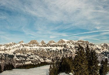
Mit der Luftseilbahn ab Tannenbodenalp zum Maschgenkamm. Den höheren Weg zum Sächsersee einschlagen, so ist der Anstieg nie richtig spürbar. Der Übergang nach links ist etwas ruppig, dann geht es aber wieder relativ bequem bis zur SAC-Hütte. Von der Hütte ein Stück zurück, nach rechts hinunter zur Furschalp. Die Furschalp ist ein Hit. Von da geht es ein Stück der Strasse entlang um dann eine Abkürzung zum Kamm zu nehmen. Reine Marschzeit ist 4:30 h. Fast 2 Stunden rechnen wir für die Pausen
Localisation
Commentaires
Randonnées à proximité
![Randonnée Marche Quarten - Höhenwanderung Maschgenkamm-Murgsee - Photo](https://media.geolcdn.com/t/375/260/ext.jpg?maxdim=2&url=https%3A%2F%2Fstatic1.geolcdn.com%2Fsiteimages%2Fupload%2Ffiles%2F1553511878bg_sport_marche.png)
![Marche Marche](https://static1.geolcdn.com/sitytour/trail-icons/101.png)
Marche
![](/images/other/stat-length.png)
![](https://static1.geolcdn.com/siteimages/upload/files/16400158638029165_repeat_loop_refresh_sync_direction_icon.png)
![Randonnée A pied Walenstadt - Walenstadt - Pluder - Photo](https://media.geolcdn.com/t/375/260/f2f44868-cecd-4f43-90e0-8033a6707992.jpeg&format=jpg&maxdim=2)
![A pied A pied](https://static1.geolcdn.com/sitytour/trail-icons/100.png)
A pied
![](/images/other/stat-length.png)
![](https://static1.geolcdn.com/siteimages/upload/files/16400158638029165_repeat_loop_refresh_sync_direction_icon.png)
![Randonnée A pied Walenstadt - Pluder - Bergheim Vadella - Photo](https://media.geolcdn.com/t/375/260/a41923a2-5a3b-4b8d-8a8a-9e4f6c4dbf8b.jpeg&format=jpg&maxdim=2)
![A pied A pied](https://static1.geolcdn.com/sitytour/trail-icons/100.png)
A pied
![](/images/other/stat-length.png)
![](https://static1.geolcdn.com/siteimages/upload/files/16400158638029165_repeat_loop_refresh_sync_direction_icon.png)
![Randonnée A pied Flums - Bergheim Vadella - Bildbrugg - Photo](https://media.geolcdn.com/t/375/260/a41923a2-5a3b-4b8d-8a8a-9e4f6c4dbf8b.jpeg&format=jpg&maxdim=2)
![A pied A pied](https://static1.geolcdn.com/sitytour/trail-icons/100.png)
A pied
![](/images/other/stat-length.png)
![](https://static1.geolcdn.com/siteimages/upload/files/16400158638029165_repeat_loop_refresh_sync_direction_icon.png)
![Randonnée A pied Flums - 7-Gipfel-Tour - Photo](https://media.geolcdn.com/t/375/260/c2e664f0-e400-4b71-9f4d-996bd72bff79.jpeg&format=jpg&maxdim=2)
![A pied A pied](https://static1.geolcdn.com/sitytour/trail-icons/100.png)
A pied
![](/images/other/stat-length.png)
![](https://static1.geolcdn.com/siteimages/upload/files/16400158638029165_repeat_loop_refresh_sync_direction_icon.png)
![Randonnée A pied Quarten - Oberterzen - Hessenberg - Photo](https://media.geolcdn.com/t/375/260/635ff4d9-89f4-4d2f-8049-7fc584df7199.jpeg&format=jpg&maxdim=2)
![A pied A pied](https://static1.geolcdn.com/sitytour/trail-icons/100.png)
A pied
![](/images/other/stat-length.png)
![](https://static1.geolcdn.com/siteimages/upload/files/16400158638029165_repeat_loop_refresh_sync_direction_icon.png)
![Randonnée A pied Quarten - Oberterzen - Heusee - Photo](https://media.geolcdn.com/t/375/260/9af17ee1-00f1-4340-9b59-dc260aba1df2.jpeg&format=jpg&maxdim=2)
![A pied A pied](https://static1.geolcdn.com/sitytour/trail-icons/100.png)
A pied
![](/images/other/stat-length.png)
![](https://static1.geolcdn.com/siteimages/upload/files/16400158638029165_repeat_loop_refresh_sync_direction_icon.png)
![Randonnée A pied Quarten - Zigerfurgglen - Heusee - Photo](https://media.geolcdn.com/t/375/260/9af17ee1-00f1-4340-9b59-dc260aba1df2.jpeg&format=jpg&maxdim=2)
![A pied A pied](https://static1.geolcdn.com/sitytour/trail-icons/100.png)
A pied
![](/images/other/stat-length.png)
![](https://static1.geolcdn.com/siteimages/upload/files/16400158638029165_repeat_loop_refresh_sync_direction_icon.png)
![Randonnée A pied Quarten - Rotenberg - Maschgenkamm - Photo](https://media.geolcdn.com/t/375/260/47ae1c87-f47a-4881-99a5-9c0ff652bf5b.jpeg&format=jpg&maxdim=2)
![A pied A pied](https://static1.geolcdn.com/sitytour/trail-icons/100.png)
A pied
![](/images/other/stat-length.png)
![](https://static1.geolcdn.com/siteimages/upload/files/16400158638029165_repeat_loop_refresh_sync_direction_icon.png)