![](/images/other/stat-length.png)
![Randonnée A pied Péruwelz - Callenelle (BE) transfrontalier Version Courte - Photo](https://media.geolcdn.com/t/1900/400/ext.pjpeg?maxdim=2&url=https%3A%2F%2Fstatic1.geolcdn.com%2Fsiteimages%2Fupload%2Ffiles%2F1545311037marcheuse_200dpi.jpg)
Callenelle (BE) transfrontalier Version Courte
Randonneur Club Marcquois
RCM ... l'esprit rando à vélo et à pied !
![Longueur](/images/other/stat-length.png)
Longueur
23 km
![Altitude max](https://static1.geolcdn.com/siteimages/upload/files/1508320355ic_sort_altitude_max_24dp.png)
Altitude max
51 m
![Dénivelé positif](https://static1.geolcdn.com/siteimages/upload/files/1508320355ic_sort_den_pos_24dp.png)
Dénivelé positif
148 m
![Km-Effort](/images/other/stat-length.png)
Km-Effort
25 km
![Altitude min](https://static1.geolcdn.com/siteimages/upload/files/1508320355ic_sort_altitude_min_24dp.png)
Altitude min
12 m
![Dénivelé négatif](https://static1.geolcdn.com/siteimages/upload/files/1508320355ic_sort_den_neg_24dp.png)
Dénivelé négatif
148 m
![Boucle](https://static1.geolcdn.com/siteimages/upload/files/16400158638029165_repeat_loop_refresh_sync_direction_icon.png)
Boucle
Oui
Date de création :
2019-01-08 12:18:39.727
Dernière modification :
2019-01-22 12:12:05.372
![A pied](https://static1.geolcdn.com/sitytour/trail-icons/100.png)
--
Difficulté : Facile
![Scannez ce code QR pour ouvrir la randonnée dans l'application SityTrail](https://capi.geolives.com/qq0zvz2zws4bq2lad0pu/sitytour/trails/2021967/qr.png?size=200)
Application GPS de randonnée GRATUITE
À propos
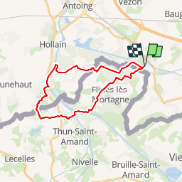
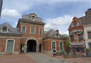
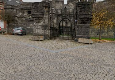
Randonnée A pied de 23 km à découvrir à Wallonie, Hainaut, Péruwelz. Cette randonnée est proposée par Randonneur Club Marcquois.
Description
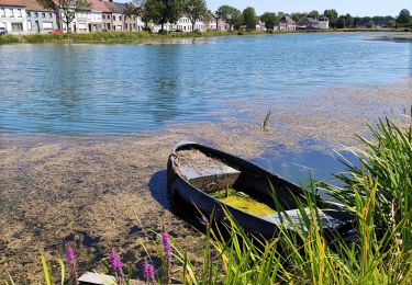
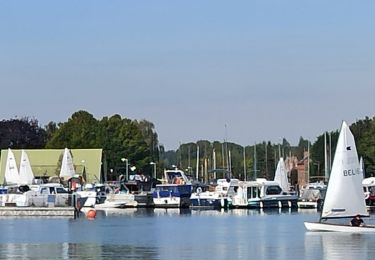
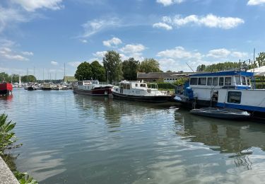
Simple randonnée à travers la campagne paisible et de la forêt de Mortagne à l'affut de jolis points de vue sur des sentiers de randonnée.
Localisation
Pays :
Belgique
Région :
Wallonie
Département/Province :
Hainaut
Commune :
Péruwelz
Localité :
Callenelle
Départ:(Dec)
Départ:(UTM)
536627 ; 5597530 (31U) N.
Commentaires
Randonnées à proximité
![Randonnée Marche Antoing - grand large- penonnes lez antoing - Photo](https://media.geolcdn.com/t/375/260/ext.jpg?maxdim=2&url=https%3A%2F%2Fservices.sitytrail.com%2FGeolivesWS%2FDownloadMedia.ashx%3FTrailID%3D653025%26Media%3Dfix__20161029165326.jpg)
![Marche Marche](https://static1.geolcdn.com/sitytour/trail-icons/101.png)
grand large- penonnes lez antoing
Marche
Facile
(3)
Antoing,
Wallonie,
Hainaut,
Belgique
![](/images/other/stat-length.png)
9,9 km | 10,7 km-effort
2h 12min
![](https://static1.geolcdn.com/siteimages/upload/files/16400158638029165_repeat_loop_refresh_sync_direction_icon.png)
Oui
![Randonnée Marche Antoing - Balade au coeur de Péronnes - Photo](https://media.geolcdn.com/t/375/260/d7561409-c7bf-436c-aa67-e1ca13223359.jpg&format=jpg&maxdim=2)
![Marche Marche](https://static1.geolcdn.com/sitytour/trail-icons/101.png)
Balade au coeur de Péronnes
Marche
Facile
(1)
Antoing,
Wallonie,
Hainaut,
Belgique
![](/images/other/stat-length.png)
4,5 km | 4,9 km-effort
1h 6min
![](https://static1.geolcdn.com/siteimages/upload/files/16400158638029165_repeat_loop_refresh_sync_direction_icon.png)
Oui
![Randonnée V.T.T. Péruwelz - Circuit transfrontalier de la Vergne - Photo](https://media.geolcdn.com/t/375/260/ext.jpg?maxdim=2&url=https%3A%2F%2Fpivotmedia.tourismewallonie.be%2FANX-02-000EXG%2FANX-02-000EXG.jpg)
![V.T.T. V.T.T.](https://static1.geolcdn.com/sitytour/trail-icons/202.png)
Circuit transfrontalier de la Vergne
V.T.T.
Facile
Péruwelz,
Wallonie,
Hainaut,
Belgique
![](/images/other/stat-length.png)
18,8 km | 19,9 km-effort
1h 22min
![](https://static1.geolcdn.com/siteimages/upload/files/16400158638029165_repeat_loop_refresh_sync_direction_icon.png)
Oui
![Randonnée A pied Antoing - Circuit du Pays Blanc - Photo](https://media.geolcdn.com/t/375/260/ext.jpg?maxdim=2&url=https%3A%2F%2Fpivotmedia.tourismewallonie.be%2FANX-02-04JV-0001%2FANX-02-04JV-0001.jpg)
![A pied A pied](https://static1.geolcdn.com/sitytour/trail-icons/100.png)
Circuit du Pays Blanc
A pied
Facile
Antoing,
Wallonie,
Hainaut,
Belgique
![](/images/other/stat-length.png)
12,3 km | 14,3 km-effort
3h 14min
![](https://static1.geolcdn.com/siteimages/upload/files/16400158638029165_repeat_loop_refresh_sync_direction_icon.png)
Oui
![Randonnée Marche Mortagne-du-Nord - Mortagne-du-Nord 18,6 km - Photo](https://media.geolcdn.com/t/375/260/fd97f041-03e8-458c-b32d-9e5c0c535a41.jpg&format=jpg&maxdim=2)
![Marche Marche](https://static1.geolcdn.com/sitytour/trail-icons/101.png)
Mortagne-du-Nord 18,6 km
Marche
Mortagne-du-Nord,
Hauts-de-France,
Nord,
France
![](/images/other/stat-length.png)
18,6 km | 20 km-effort
4h 20min
![](https://static1.geolcdn.com/siteimages/upload/files/16400158638029165_repeat_loop_refresh_sync_direction_icon.png)
Oui
![Randonnée Marche Antoing - grand large tour complet - Photo](https://media.geolcdn.com/t/375/260/7b8247cc-273c-44b2-9d0f-76799d55f4b8.jpg&format=jpg&maxdim=2)
![Marche Marche](https://static1.geolcdn.com/sitytour/trail-icons/101.png)
grand large tour complet
Marche
Facile
Antoing,
Wallonie,
Hainaut,
Belgique
![](/images/other/stat-length.png)
9,5 km | 10,4 km-effort
2h 15min
![](https://static1.geolcdn.com/siteimages/upload/files/16400158638029165_repeat_loop_refresh_sync_direction_icon.png)
Oui
![Randonnée Marche Antoing - Peronnes 16,9 km - Photo](https://media.geolcdn.com/t/375/260/bd92a62e-6683-4cf8-93be-bb4770bda203.jpg&format=jpg&maxdim=2)
![Marche Marche](https://static1.geolcdn.com/sitytour/trail-icons/101.png)
Peronnes 16,9 km
Marche
Facile
Antoing,
Wallonie,
Hainaut,
Belgique
![](/images/other/stat-length.png)
16,9 km | 18,5 km-effort
4h 34min
![](https://static1.geolcdn.com/siteimages/upload/files/16400158638029165_repeat_loop_refresh_sync_direction_icon.png)
Oui
![Randonnée Marche Flines-lès-Mortagne - De Flines les Mortane à Bernissart (Belgique) - Photo](https://media.geolcdn.com/t/375/260/ca739f87-71b6-494f-8d4f-d2141a94b6cf.jpg&format=jpg&maxdim=2)
![Marche Marche](https://static1.geolcdn.com/sitytour/trail-icons/101.png)
De Flines les Mortane à Bernissart (Belgique)
Marche
Moyen
Flines-lès-Mortagne,
Hauts-de-France,
Nord,
France
![](/images/other/stat-length.png)
26 km | 27 km-effort
6h 42min
![](https://static1.geolcdn.com/siteimages/upload/files/16400158638029165_repeat_loop_refresh_sync_direction_icon.png)
Non
![Randonnée Marche Antoing - PERONNES - LEZ - ANTOING _Marche Fédérale _ HT _ 03/12/2022 - Photo](https://media.geolcdn.com/t/375/260/74c5a77e-93ee-40e5-88c8-a2bf6ff7ab48.jpg&format=jpg&maxdim=2)
![Marche Marche](https://static1.geolcdn.com/sitytour/trail-icons/101.png)
PERONNES - LEZ - ANTOING _Marche Fédérale _ HT _ 03/12/2022
Marche
Moyen
Antoing,
Wallonie,
Hainaut,
Belgique
![](/images/other/stat-length.png)
18,4 km | 20 km-effort
4h 13min
![](https://static1.geolcdn.com/siteimages/upload/files/16400158638029165_repeat_loop_refresh_sync_direction_icon.png)
Oui